


Local Plan 2023-2040
Published 8th January 2024 An accessible document from southtyneside.gov.uk
Foreword
South Tyneside Council is an ambitious local authority, determined to continue delivering for local residents and businesses, realising our long-term strategic vision of making South Tyneside an outstanding place to live, invest and bring up families.
South Tyneside is a unique and special place, a coastal community proud of its history, cultural and natural assets, and strong communities, but with ambitions that include raising prosperity and providing opportunities for residents now and in the future.
This Local Plan proposes a strategy for the future development of the borough until 2040. It will deliver new development and positive growth that meets the needs and aspirations of South Tyneside. It will deliver new housing and employment throughout the borough and will strengthen communities with new infrastructure.
It seeks to deliver this growth in a sustainable and inclusive way, protecting those assets which give South Tyneside its identity and special character, whilst enhancing our natural environment and recognising the current and future pressures of a changing climate.
The South Tyneside Local Plan will ensure the borough has robust, effective, and up to date planning policies which will help to deliver the long term aims and objectives for the borough as a whole, whilst offering protection to South Tyneside’s most sensitive assets and designations. The Local Plan provides a framework that will ensure that South Tyneside continues to deliver safe and healthy places to live, learn and work.
Introduction
All Local Planning Authorities have a statutory duty to prepare a Local Plan. The South Tyneside Local Plan (hereafter referred to as the Plan) is a planning framework to guide decisions and to shape development in the borough until 2040.
Planning affects everyone. The homes we live in, the places we work, the greenspaces where we relax and the roads we travel on, are all a result of planning decisions. This Plan is the starting point for the determination of all planning applications. It sets a clear strategy for bringing land forward to address the borough’s objectively assessed needs in line with the presumption in favour of sustainable development. It provides certainty and transparency to residents and businesses as to how South Tyneside will develop by 2040. Once adopted, the Plan will provide:
- A framework to meet the needs of South Tyneside’s communities in a positive, managed, and sustainable way
- Priorities for investment in jobs, homes, and the timely delivery of the infrastructure necessary to support this growth
- A mechanism for seeking the reduction of carbon emissions and creating a resilient and enhanced natural environment.
South Tyneside Development Plan
The plans and policies that make up the Development Plan are:
- The South Tyneside Local Plan
- The International Advanced Manufacturing Park Area Action Plan (IAMP AAP)
- Any made Neighbourhood Plans.
The Development Plan policies within the South Tyneside Local Plan, along with the IAMP AAP and any made Neighbourhood Plans provide the Framework against which all planning applications should be determined.
All policies in the Development Plan will be monitored regularly and reviewed (in accordance with the Monitoring Frameworks) and updated, if necessary, to ensure that the Development Plan is up-to date. The Council’s Local Development Scheme (LDS) provides details of timescales for preparing and reviewing the Development Plan.
Once this Plan is adopted, this will replace the Councils current Local Development Framework. Appendix 1 lists the Development Plan Documents (DPDs) which will be superseded.
Neighbourhood Plans
The Localism Act 2011 gave local communities the power to produce a neighbourhood plan for their area. Once ‘made’ (adopted) following an independent examination, and agreed by the community following a referendum, these plans form part of the statutory Development Plan.
Two Neighbourhood Forums have progressed Neighbourhood Plans in South Tyneside:
-
East Boldon Neighbourhood Plan
The East Boldon Neighbourhood Plan was ‘made’ in December 2021. The East Boldon Neighbourhood Plan provides a suite of policies which seek to ensure new development meets the needs of and makes a positive contribution to the village.
-
Whitburn Neighbourhood Plan
The Whitburn Neighbourhood Plan was ‘made’ in September 2022. The Plan’s vision is to ensure Whitburn village will continue as a sustainable and well-supported, thriving community. It will conserve and enhance its unique character as a coastal village set within a rural environment with a rich heritage and natural environment. It will be forward looking and resilient to the effects of climate change.
The relationship between the Local Plan and Neighbourhood Plans
Once ‘made’ Neighbourhood Plans become part of the statutory development plan. Planning applications which fall within the neighbourhood plan area must have regard to the neighbourhood plan policies unless material considerations indicate otherwise.
Where relevant, development proposals in Neighbourhood Plan areas should be informed by made neighbourhood plans from the outset and regard should be had to additional supporting documents including Design Codes.
Neighbourhood Plans can be prepared at any time, but they must be in general conformity with the adopted Development Plan’s strategic policies. The strategic policies within the Local Plan are set out below:
- Policy SP1: Presumption in favour of Sustainable Development
- Policy SP2: Strategy for Sustainable Development to meet identified needs
- Policy SP3: Spatial Strategy for sustainable development
- Policy SP4: Housing Allocations in the Main Urban Area
- Policy SP5: Brinkburn
- Policy SP6: Chuter Ede
- Policy SP7: Urban and Village Sustainable Growth Areas
- Policy SP8: Fellgate Sustainable Growth Area
- Policy SP9: Strategic Vision for South Shields Town Centre
- Policy SP10: South Shields Riverside Regeneration Area
- Policy SP11: South Shields Town Centre College Regeneration Site
- Policy SP12: Fowler Street Improvement Area
- Policy SP13: Foreshore Improvement Area
- Policy SP14: Wardley Colliery
- Policy SP15: Climate Change
- Policy SP16: Housing Supply and Delivery
- Policy SP17: Strategic Economic Development
- Policy SP18: Employment land for general economic development
- Policy SP19: Provision of land for Port and River related development
- Policy SP20: The Hierarchy of centres
- Policy SP21: Natural Environment
- Policy SP22: Green and Blue Infrastructure
- Policy SP23: Sports provision and Playing Pitches
- Policy SP24: Heritage Assets
- Policy SP25: Transport and Infrastructure
- Policy SP26: Delivering Sustainable Transport
Supplementary Planning Documents (SPDs)
The Council has several SPDs in place which provide more detail in relation to specific policies. These are listed in Appendix 2. In due course, the Council will review all SPDs and where necessary will revoke them or update them to reflect the Development Plan. The Local Development Scheme (LDS) will be updated to reflect any changes to proposed SPDs.
The North East Marine Plan
The 2009 Marine and Coastal Access Act introduced a marine planning system with requirements to produce plans to enable sustainable development of marine areas, similar to land-use plans. South Tyneside overlaps with the area covered by the North East Marine Plan (2021) which sets the policies for the sustainable development of the marine environment.
The Marine Plan and Local Plan areas of jurisdiction overlap in the intertidal zone, between mean high-water springs (MHWS) and mean low water springs including the tidal extent of rivers, and as such any applications for development within this area would need to refer to both.
The North East Marine Plan may have relevance for proposals that are above MHWS, but are capable of affecting the marine area, such as a land-based development that may eventually discharge into the sea or change the seascape character.
Proposals for development that can affect the marine plan area, and tidal rivers, must consider North East Marine Policies alongside the South Tyneside Local Plan. To assist applicants, the Council and the Marine Management Organisation (MMO) will seek to coordinate advice given to applicants.
Preparing this Plan
The Council will prepare a Compliance Statement which will set out how the Council has positively prepared the Plan in accordance with legislation, regulations, and national policy. It will also include a justification for how this Plan has met the legal and regulatory requirements and how it meets the test of soundness.
National Planning Policy Framework (NPPF)
On 20 December 2023, a revised NPPF was published. Paragraph 230 states that the policies in the revised NPPF will apply for the purpose of examining plans, where those plans reach regulation 19 of the Town and Country Planning (Local Planning) (England) Regulations 2012 (pre-submission) stage after 19 March 2024. Accordingly, the South Tyneside’s Publication draft Local Plan has been prepared in accordance with the NPPF as of September 2023. References to the NPPF within this paper therefore refer to the September 2023 NPPF.
Evidence and Assessing impacts
The Plan has been informed through a variety of statutory and non-statutory appraisals and assessments. These include:
Evidence
The Plan’s policies and proposals have been informed by an extensive range of evidence and studies.
Habitats Regulation Assessment (HRA)
This is the statutory process to assess the potential impacts of the Plan on Habitats sites as set out in The Conservation of Habitats and Species (Amendment) (EU Exit) Regulations 2019. Habitats sites are of exceptional international importance in respect of rare, endangered, or vulnerable natural habitats and species and include Special Protection Areas, Special Areas of Conservation, European Marine Sites and Ramsar sites. As the Regulations apply the precautionary principle, plans can only be adopted if there is likely to be no adverse impact on the integrity of the site(s) in question.
Sustainability Appraisal (SA)
This is a statutory process integrated into the preparation of all aspects of the Plan. The process measures the potential impacts of the Plan on a range of economic, social, and environmental considerations and includes the requirements of Strategic Environmental Assessment legislation. The SA has been designed to incorporate the principles of an Equality Impact Assessment and a Health Impact Assessment. This is to ensure that these aspects are fully embedded into the process of developing the Plan and to negate the need to produce separate documents as the Plan progresses.
The separately published SA Report makes clear how environmental considerations have been integrated into the Plan, the reasons for choosing the selected approach over the alternatives considered, and the arrangements for monitoring the significant environmental effects of the Plan.
Duty to Co-operate Statement
This is a statement summarising the work that the Council has undertaken with neighbouring local authorities and statutory bodies in the preparation of the Plan.
Plan Period
The Plan period is from April 1st 2023 to 31st March 2040.
Structure of the Plan
The Plan sets out the proposed policies, and the justification which supports them. The Plan must therefore be read as a ‘whole’ i.e. with reference to all relevant policies that will collectively determine what constitutes “sustainable development”. This Plan has four sections:
Section 1: Introduction
This section introduces the Plan, its structure and how it was prepared. It also includes a chapter on South Tyneside today. It summarises the key features and characteristics of the borough and highlights some of the challenges and opportunities the borough may face up to 2040.
Section 2: Spatial Vision and Spatial Strategy
This section sets out the Council’s vision and strategic priorities for the borough. It outlines the spatial strategy for how and where the future growth of South Tyneside will be delivered and contains strategic allocations which are fundamental to the delivery of the Plan.
Section 3: Thematic Policies
This section includes the Local Plan policies. The Plan includes the following chapters and themes:
- Chapter 4: Strategy for Sustainable Development - Key strategic policies setting scale and location of growth
- Chapter 5: Strategic Allocations – Sites allocated for development
- Chapter 6: Promoting Healthy Communities – Policies seeking to improve health and wellbeing for residents
- Chapter 7: Meeting the challenge of Climate Change, Flooding and Coastal Change – Policies seeking to support renewables energy and carbon reduction, mitigate and adapt to the effects of climate change and reduce flooding impacts
- Chapter 8: Delivering a mix of homes – Policies seeking to deliver high quality housing
- Chapter 9: Building a strong, competitive economy – Policies supporting economic development
- Chapter 10: Ensuring the vitality of Centres – Policies supporting retail uses in town and district centres
- Chapter 11: Conserving and enhancing the natural environment – Policies to protect and enhance the natural environment, green infrastructure, and open space provision
- Chapter 12: Conserving and enhancing the historic environment – Policies which protect and enhance heritage assets
- Chapter 13: Well-designed places – Policies to ensure high quality design for new developments
- Chapter 14: Transport and Infrastructure – Policies supporting sustainable transport and infrastructure improvements
- Chapter 15: Waste and Minerals – Policies to manage waste and minerals.
Section 4: Implementation and Monitoring
This section sets out how the policies in the Plan will be implemented and includes Infrastructure and Delivery. The Monitoring Framework details how the policies will be monitored.
Strategic and Local Policies
The National Planning Policy Framework (NPPF) 2023 requires that plans explicitly set out which policies are strategic, i.e. those that address the strategic priorities of the area (including any relevant cross boundary issues). This Plan identifies these policies using the suffice SP. Strategic policies set out the overall strategy for the pattern, scale, and quality of development. The Plan contains detailed local policies that address a range of themes.
Policies Map
A separate ‘Policies Map’ supports the Plan and illustrates those policies which relate to a specific place or area.
Allocations identified on the Policies Map should be read in conjunction with the relevant policy in the Plan that sets out the criteria that planning applications will need to comply with. Inclusion as an allocated site within the Plan indicates that the principle of development on that site is acceptable.
Key Diagram
The NPPF states that the broad locations for development identified in a local plan should be identified on a Key Diagram.
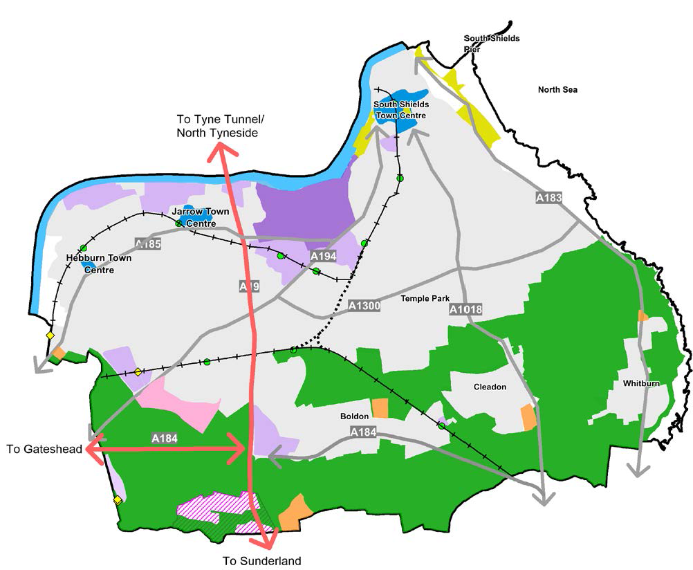
 | South Tyneside Borough Boundary |
 | Trunk Roads |
 | Major Roads |
 | Metro Line |
 | Safeguards for Potential Metro Extension |
 | Metro Stations |
 | Potential New Metro Stations |
 | Town Centres |
 | General Employment Areas |
 | Port and River Related Employment |
 | Urban and Village Growth Areas |
 | Fellgate Sustainable Growth Area |
 | Regeneration Areas |
 | IAMP AAP Boundary |
 | Green Belt |
 | River Tyne |
 | Main Urban Area |
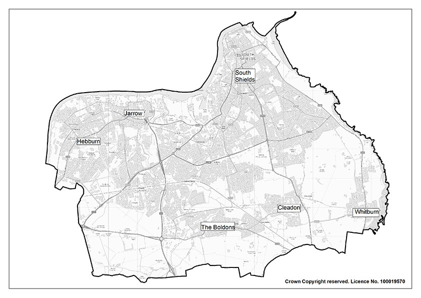
South Tyneside: Context
The South Tyneside Local Plan is based on a comprehensive understanding of the borough as it is today, and opportunities and ambitions of the council as set out in ‘The South Tyneside Vision 2023 – 2043’. This chapter provides a summary of the evidence base that has been prepared to support this Plan and the wider context and challenges facing South Tyneside.
South Tyneside
South Tyneside is located within the North East of England, sitting within the Tyne and Wear conurbation. Natural boundaries include the River Tyne to the north and the North Sea to the east, whilst the neighbouring authorities of Sunderland and Gateshead lie to the south and west. The borough is relatively compact and predominantly urban in character, covering an area of 64 sq. km. The boroughs built-up area covers approximately 60% of the land area. The Tyne and Wear Green Belt wraps around the borough to the south and extends to Sunderland and Gateshead’s administrative boundaries.
The development pattern of South Tyneside includes a main urban area to the north of the borough and villages in the south:
Main Urban Area
The main urban area covers the northern part of South Tyneside. It is densely developed and extends along the riverside to the coast. It includes the three main towns of South Shields, Hebburn and Jarrow. The main urban areas support the majority of the residential and employment areas in South Tyneside. The three town centres provide the main locations of retail provision, with South Shields town centre regarded as the principal location for retail and leisure facilities. Key employment areas along the River Tyne include land associated with the Port of Tyne. The main urban area is highly accessible and supported by bus routes and metro services. South Shields town centre is also serviced by the Shields Ferry, providing a direct link to North Shields.
Villages and Green Belt
The areas of the Boldons, Cleadon and Whitburn village are separated from the main urban area, and each other, by farmland which also forms part of the Green Belt. The villages provide a mix of residential areas, and each are served by local centres and services. Good connections to the A19 road network support areas of economic activity, including Boldon Business Park, the International Advanced Manufacturing Park (IAMP) and Wardley Colliery.
The Green Belt area includes areas of historic, landscape and ecological importance.
Population of South Tyneside
The current resident population of South Tyneside is 147,800 (2021 Census). The population of South Tyneside has fallen by 0.2% from 2011. However, the ONS 2018-based population projections indicate that the population of South Tyneside is expected to grow over the plan period, with an estimate population of 155,694 in 2030 and 158,825 in 2040.
The demographic makeup of our population is also changing. 61.2% of the population are of working age but this is projected to fall by 1% between 2018 and 2028. The age make-up of our population largely mirrors the regional and national picture, although a larger share of our population is over 65, and this figure expected to grow.
Ethnic diversity in the borough is relatively low, with 94.4% of residents identifying as White and 5.6 % of residents from ethnic minority backgrounds, which is lower than regional (7%) and national (19%) levels.
South Tyneside faces significant challenges, including areas of high deprivation. It is ranked the 27th most deprived out of 317 local authorities nationally in the Index of Multiple Deprivation (2019). The borough is more deprived that its Tyne and Wear neighbours and is the 3rd most deprived borough in the North East region. South Tyneside also has a higher level of child poverty, and a higher proportion of workless households than the regional and national averages. However, there are real differences across our borough with a real polarisation between our more deprived wards in the main urban area, and less deprived wards in the villages.
Promoting Healthy Communities
Ensuring residents are ‘Healthy and Well’ is one of five key ambitions of South Tyneside Council 20-year Vision.
During 2018-20 in South Tyneside, life expectancy at birth was three years below the national average for men and two years for women (76.4 years for men and 81.2 for women, compared to 79.4 and 83.1 nationally). At ward level, there is difference of over ten years between the poorest and wealthiest areas of the borough in terms of life expectancy in men and over 9 years in women (data from 2016-20).
From 2018-20 in South Tyneside, healthy life expectancy was almost six years below the national average for men and five years lower for women (57.3 for men and 58.9 for women, compared to 63.1 and 63.9 nationally).
South Tyneside has significant health challenges, with higher- than-average rates of premature deaths, including those from cardio-vascular disease and cancer. South Tyneside residents are more likely than the national average to engage in behaviours which are risk factors for poor health. 15.2% of South Tyneside adults are smokers, compared to 12.7% of adults nationally. Just 61.5% of adults engage in regular physical activity, compared to 67.3% of adults nationally. 76.3% of adults are classified as overweight or obese, compared to a 63.8% English average.
To rise to these challenges there are a range of health assets in South Tyneside that acknowledge these inequalities and support the health and wellbeing of residents. We are aware that more can be done to meet the needs of our residents. We recognise that the local infrastructure can have a huge positive impact on wellbeing.
This includes the South Tyneside and Sunderland NHS Foundation Trust who manage both hospital and community health services across South Tyneside. The Cumbria, Northumberland and Tyne and Wear Foundation Trust who is one of the largest mental health and disability trusts in England. They provide mental health, learning disability and neurological care for people across the north of England.
In 2023 Primary Care Services in South Tyneside included:
- 21 GP practices in three Primary Care Networks (PCNs): Seven practices in PCN East, six in PCN South and eight in PCN West
- 23 contracted dental practices across 20 sites
- 16 optometric practices
- 34 pharmacies.
South Tyneside recognises that a substantial part of the difference in health outcomes is down to the social, economic and environmental factors that shape people’s lives. These factors are collectively described as the wider determinants of health and include the built and natural environment, education, income, work and the labour market, crime and social capital. The mechanisms by which the wider determinants influence both mental and physical health can be complex and inter-related, often acting over a long time.
The Local Plan therefore has the potential to play a significant role in health improvement. It is essential therefore that every opportunity is taken to embed health in all policies related to the built environment and other key factors that impact on these wider determinants, ensuring that South Tyneside meets one of the five ambitions that residents are Healthy and Well.
Climate Change and Renewables
Climate Change is expected to be a defining issue of our time and is one that South Tyneside Council is committed to tackling. In July 2019 the Council declared a Climate Change emergency and committed to taking all necessary steps to make South Tyneside Council carbon neutral by 2030. Climate Change risks to the borough include surface water and tidal flooding, overheating, sea level rise and coastal erosion.
In recent years, in line with the UK, South Tyneside has seen a steady reduction in carbon dioxide emissions. From 2005 to 2017, carbon emissions have fallen by 37%, across three sectors: domestic, transport and commercial/ industrial. This represents a fall from 5.6 tonnes in 2005 to 3.5 tonnes in 2017 per person. One of the main drivers for reduced levels of emissions has been a decline in the use of coal for electricity generation. However, reductions in emissions from domestic use and transport have not seen as great a decrease as industry and commercial emissions.
Risks from increased rainfall and storms are issues which could impact the borough. The borough’s Flood and Coastal Risk Management Strategy (2017-2022) highlights that sea level rise, changes in wave directions, potential increase in intensity, severity and frequency of coastal storms, and rainfall events are likely to have impacts in terms of coastal and river erosion.
A Level 1 Strategic Flood Risk Assessment (SFRA) has been undertaken to help identify the number and spatial distribution of flood risk sources present throughout the South Tyneside Council’s Local Plan area. This has then informed the application of the Sequential Test, a tool used for steering new development to areas with the lowest risk of flooding from any source.
Delivering a mix of homes
Housing plays a fundamental role in supporting the health and wellbeing of its residents and it is vital to ensure more housing choice is available.
South Tyneside has approximately 72,000 dwellings. Most residents live in privately owned homes, 30.1 % live in affordable housing, including social rented accommodation and 13.1% of households live in privately rented accommodation.
The South Tyneside Integrated Housing Strategy (2019) states that property types vary throughout the borough, although the choice of accommodation in certain areas is limited. There is a high percentage of older properties in Inner South Shields, compared to the highest level of new build accommodation which can be found in Hebburn.
Key conclusions of the Strategic Housing Market Assessment (SHMA) (2023) are that there needs to be a broader and more diverse housing offer for older people across South Tyneside and there is a significant need for more affordable housing.
The evidence from engagement through the SHMA suggests that the inner urban areas have a more challenging housing market and that many of the more desirable market areas within South Tyneside (e.g. the Boldons, Cleadon, and Whitburn village) have a limited amount of family market housing due to planning constraints such as Green Belt.
There continues to be demand for affordable housing units across the borough. The SHMA found that there was a need for an additional 361 affordable units per year, which would include social / affordable units or intermediate tenure.
Within South Tyneside, affordable housing is delivered by the Council, Registered Providers, or private developers. The social housing sector has received significant investment through South Tyneside Homes and other registered providers which have supported improvements to the overall condition of the existing stock to meet the Decent Homes Standard.
The borough has an ageing population and therefore an increasing demand for specialist housing to support elderly people in the community. The South Tyneside Adult Social Care Accommodation Strategy (2022) identifies a need for additional Extra Care accommodation to cater for the needs of the elderly population.
The NPPF places a requirement on Local Authorities to not only identify enough sites to meet our housing needs, but to also make sure that they are delivered. The Government has recently introduced penalties through the annual ‘Housing Delivery Test’ for authorities which are failing to do this. The Housing Delivery Test results for 2021 show that South Tyneside is currently failing to deliver enough housing to meet our needs. This means that the development plan policies that are currently used to help it determine planning applications have less weight.
The Strategic Housing Land Availability Assessment (SHLAA) assesses the potential future supply of deliverable and developable housing land that is suitable, available, and achievable over a 15- year period.
The SHLAA has helped to inform the Plan by identifying the most suitable sites to allocate for housing.
In total, the SHLAA (2023) assessed 515 sites across the borough which currently do not benefit from planning consent for residential development including land in the Green Belt. The SHLAA concluded that the capacity of potential housing sites from non-Green Belt sources including urban brownfield sites is not sufficient to deliver the residual housing requirement for the borough (by residual the Council means once the supply from existing planning permissions has been considered).
There remains an acute shortfall in the supply of housing land from non-Green Belt sources. This scale of under provision is such that it would not be realistic for the Plan to rely on the possibility that enough ‘windfall’ sites may, at some point over the Plan period, come forward to meet the shortfall. England operates in a ‘plan-led’ system and the Council’s Plan must provide a high degree of certainty to effectively coordinate and deliver the necessary supporting infrastructure. It is therefore necessary for the Plan to amend Green Belt boundaries to deliver the housing requirement.
South Tyneside has an established community of Gypsies and Travellers. There is one permanent site for the Gypsy and Travelling community at West Pastures, West Boldon. This site is fully authorised and was granted planning permission in December 2013 for 11 Gypsy and Traveller pitches. The borough does encounter unauthorised encampments. However, these are small and temporary in nature with Gypsies and Travellers generally passing through the borough. There are no Travelling Showperson’s yards in the borough but there is an Amusement Park Caravan Site on South Promenade, South Shields.
Building a strong, competitive economy
South Tyneside is an area with many economic strengths including advanced manufacturing expertise, a strong visitor economy and health and social care sectors, and a growing reputation in the green economy. The borough has seen strong growth in its business base and in higher-skilled roles, whilst economic investment has created regionally significant employment sites with excellent transport links and seen improvements in skills and digital infrastructure.
South Tyneside has a higher than average proportion of jobs in the manufacturing sector, with employment and business concentrated in foundational industries such as health and social care, retail and construction.
South Tyneside faces challenges which have been exacerbated by the Covid-19 pandemic, leaving the borough lagging behind the North East and UK on most economic indicators. This is particularly evident in unemployment rates, with only 69.3% of the local population in employment, compared to regional average of 71.2%. 8.3% of 18–24-year- olds are unemployed, which is twice the national average (4.7%). Furthermore, higher level education skills and qualifications are lower than regional and national averages.
Employment premises have traditionally been concentrated along the riverside. The northern industrial estates typically accommodate a range of premises including factories, workshops, warehouses, and offices. Offices are distributed across the borough, but with a noticeable cluster around South Shields town centre which is the main administrative, retail and service centre for South Tyneside.
The western part of the borough is well served by the strategic highway network; access to the A19 is a key requirement for manufacturing and distribution businesses. Business Parks in the south and west of the borough are experiencing the highest demand given their transport links, particularly Monkton Business Park and Boldon Business Park. The Local Economic Assessment (LEA) (2022) states that there is an undersupply of both office and industrial premises which is acting as a barrier to growth for many businesses.
The LEA found evidence of clear strengths in both the advanced manufacturing and energy/ offshore wind sectors. However, the creative and digital sectors are underrepresented, skills levels are comparatively low, and the borough is overly dependent upon the public sector. The Council, through its Economic Recovery Plan (2020), is seeking to nurture a culture of entrepreneurship and support sectors that have real strengths, in addition to assisting the foundational sectors that support the borough’s economy, such as health and social care.
South Tyneside’s main strengths in advanced manufacturing are in automotive manufacturing and the related supply chain, with the cross- boundary International Advanced Manufacturing Park (IAMP) being a key asset shared with Sunderland. IAMP is identified in the LEA as providing a major opportunity to increase the number of high-quality jobs in South Tyneside and this is already happening: investment was announced in 2021 by Envision AESC for a Gigafactory to provide batteries for Electric Vehicles.
The Port of Tyne is a key offshore wind supply chain sector asset for South Tyneside. It is the operations base for the Dogger Bank wind farm, the largest in the world. The Port of Tyne and riverside employment sites provide opportunities for future growth in offshore wind sector. South Tyneside has key expertise in heat networks, with mine water and related schemes underway in Hebburn, Jarrow and at Holborn in South Shields.
Domestic tourism, particularly from day visitors, is an important contributor to the economy. South Tyneside’s visitor assets include its coastline and sandy beaches, the Ocean Beach Pleasure Park, Jarrow Hall, the Customs House, Arbeia Roman Fort and The Word (the National Centre for the Written Word).
These have helped South Tyneside to become established as a quality visitor destination. In 2019, there were 7.1 million visitors to South Tyneside and borough provided a £331m boost to the local economy.
Ensuring the vitality of Centres
The borough has three town centres – South Shields, Jarrow and Hebburn and six district centres. These centres provide the main retail, leisure and service areas for the residents of South Tyneside.
Town centres are becoming increasingly diverse with the emergence of a greater proportion of leisure, food and drink uses. There is also an identified need to concentrate multifunctional public services in town centre locations where a number of services are provided in one location.
The South Tyneside, District and Local Centres Study (2023) noted that South Tyneside’s town centres generally suffer from an oversupply of vacant, small-scale units that were formerly in retail use and highlighted the need for flexibility – town centre accommodation needs to be adaptable to different uses to address future needs.
South Shields town centre provides a strong comparison retail offer. Whilst convenience provision is below the national average. The Ocean Road area provides a strong food and drink leisure offer, which capitalises on the visitor/tourist trade driven by South Shields’ seaside location. Challenges include the high proportion of empty units compared to the national average, the lack of late-opening leisure operators in the western part of King Street and Fowler Street suffers from very high vacancies as well as an unattractive public realm.
The proposed new college campus will be located on a key site in the heart of the Town Centre. Located close to the Transport Interchange with frontage to Barrington Street and King Street, this sub area has the potential to be transformed, bringing an important new use to the Town Centre that will increase footfall.
Jarrow town centre performs well in fulfilling the retail needs of local residents and the Jarrow Focus leisure development attracts footfall and boosts the town’s overall leisure offer. Key challenges are the high unit vacancy rate, the need to encourage further independent shops or cafes to fill these vacant units, particularly along Grange Road to provide a more active frontage in this location and the need to encourage the evening economy.
Convenience retail dominates the retail offer provided by Hebburn town centre. This is supplemented by mid-sized stores operated by national grocery retailers and a range of smaller retailers offering a good level of choice for a centre of this size. Hebburn Central, which opened in 2015 provides gym, fitness class, swimming pool and library facilities which significantly boost the town’s leisure provision. This acts to drive footfall and provides a beacon for private investment.
Conserving and enhancing the historic environment
South Tyneside has a wide range of historic, archaeological, and cultural assets. The Frontiers of the Roman Empire World Heritage Site was inscribed in 2005 and consists of Hadrian’s Wall, the German Limes, and the Antonine Wall. The Arbeia Roman Fort forms part of the Hadrian’s Wall element of the Frontiers of the Roman Empire World Heritage Site. The borough also has five Scheduled Monuments including Marsden Lime Kilns and St Paul’s Monastery.
There are 11 Conservation Areas in South Tyneside and 195 Listed Building entries, including 4 Grade I and 7 Grade II* Listed Buildings.
Two historic structures currently appear on Historic England’s Heritage at Risk register. One of these is the Grade II* Listed Cleadon Water Tower, a prominent landmark based on Cleadon Hills. The chimney served a steam- powered pumping station for the Sunderland and South Shields Water Company, pumping fresh, hygienic water reserved from the underlying Magnesian limestone. 11 grade II Listed Buildings are recorded as being of ‘at risk’ on South Tyneside’s Grade II Buildings At Risk Register. Three Conservation Areas are At Risk.
The historic environment is not just about Listed Buildings or conservation areas, although these are undeniably of vital importance and contribute significantly to the unique character of the area. It is the larger number of non-designated heritage assets that reinforce local distinctiveness and sense of place. There are 244 locally listed heritage assets in South Tyneside, and many more appear on the Tyne and Wear Historic Environment Record. There are more than 2,100 records available of archaeological sites and finds in South Tyneside, ranging from prehistoric flint axes to World War II pillboxes, and this number grows every time a new find is discovered and recorded.
Well-designed places
Good design is a key aspect of sustainable development, creating better places in which to live and work and helping new development fit in with existing communities. Well-designed places use the right mix of building types, forms and scale of buildings and public spaces for the context and the proposed density, to create a coherent form of development that people enjoy.
The Masterplan Vision for South Shields (2023) sets out a framework for the future of the town centre over the next 10 years. It seeks to deliver a vibrant, attractive, and healthy town with a secure and sustainable future and a place where people want to live, work, study and socialise.
Creating active environments provides people with more opportunities for people to be active whether that be via the inclusion of more active travel opportunities, spaces to be active as well as creating and maintaining activities. South Tyneside Council recognises the importance of active environments, this is reflected in other key documents such as the South Tyneside physical activity strategy, the Local Cycling Walking Infrastructure Plan (2022) that require well designed open and accessible public spaces.
Conserving and enhancing the natural environment
The character of the landscape across the borough is varied and has been shaped by human and physical influences over time. South Tyneside lies within two national character areas defined by Natural England. The Tyne and Wear Lowlands covers the riverside and the urban areas in the borough, whilst the Durham Magnesian Limestone Plateau includes the coastal areas, the Green Belt and the villages of Cleadon, Whitburn and the Boldons.
South Tyneside’s main watercourses are the River Tyne and its tributary, the River Don, which flows through to Jarrow where it meets the Tyne. Flood risk zones in the borough are situated around the coastal and riverside areas and along the course of the River Don.
The Tyne and Wear Green Belt extends from Gateshead and Sunderland to the south of the borough. The Green Belt plays an important role in preserving the individual characters of settlements such as Cleadon and Whitburn village, whilst also separating South Tyneside from Gateshead, Sunderland and Washington. The Green Belt also contains areas of High Landscape Value, including Cleadon Hills and Boldon Downhill, and various sensitive ecological designations.
South Tyneside has a wide range of habitats which support important areas of biodiversity and geological value. The coastline is of international importance and has two European designations; the Durham Coast Special Area of Conservation (SAC) and the Northumbrian Coast Special Protection Area (SPA) and Ramsar site. These important areas support unique vegetation, being the only area of vegetated sea cliffs on magnesian limestone rock in the UK and provide habitat for non-breeding seabirds such as Turnstone and Purple Sandpiper. The borough is home to five Sites of Special Scientific Interest (SSSI’s) covering 158.8 ha, 52 Local Wildlife Sites and seven Local Nature Reserves.
The Open Space Study (2023) identifies that there is relatively good access to amenity green space across the borough, but there are significant gaps in access to allotments, parks and recreation grounds, play space and accessible natural green space. The majority of open spaces were assessed as either good or fair quality, however a significant proportion have quality issues that need addressing.
The borough has a range of sporting facilities and assets which provide opportunities for recreation. The emerging Playing Pitch Strategy identifies some shortfalls in pitch capacity for football, cricket and rugby. In terms of non-pitch sports, supply meets current demand for tennis, bowls and athletics.
Transport and Infrastructure
As part of the Tyne and Wear Conurbation, the borough is relatively well connected to the North East. Whilst the River Tyne forms a major physical barrier, the Tyne Road and Pedestrian Tunnels both traverse the river between north and south on the A19 corridor and a pedestrian ferry also connects the towns of North and South Shields.
The borough has effective public transport infrastructure, with a network of bus routes providing frequent services connecting residents to destinations throughout Tyne & Wear. This is complemented by a light rail Metro system which has 60 stations across the network and links South Tyneside with Newcastle, Sunderland, Gateshead and North Tyneside. There are 10 stations situated throughout South Tyneside.
Key road connections within the borough include:
- The A19 – a key strategic route connecting the Tyne and Wear City Region to Northumberland in the north and Durham, Hartlepool, Tees Valley and North Yorkshire in the south
- The A194(M) – connecting the A1(M) at Washington (Junction 65) and South Tyneside
- The A184 – running east to west connecting South Tyneside and Gateshead
- The A185 – running east to west connecting South Tyneside and Gateshead
- The A183 – connecting South Shields and Sunderland
- The A1018 – connecting South Shields and Sunderland.
The 2021 Census identifies that a high proportion of households in South Tyneside do not own a private motor vehicle (32.8%). This is higher than the regional (27.6%) and national (23.5%) averages. Commuting by car is the most popular mode of transport for residents within South Tyneside.
There has been a significant increase in the amount of Ultra Low Emission Vehicles (ULEVs) registered for use on public roads across England and South Tyneside is no exception. Ownership of ULEVs in the borough has seen a tenfold increase over the last several years. There are currently 53 Electric Vehicle charging posts across South Tyneside. These form part of our ongoing aspiration to decarbonise transport in the borough, as part of the climate change and net-zero targets identified in the Sustainable South Tyneside Strategy.
There is also an extensive network of Public Rights of Way in the borough, including 121km of footpath, 104km of cycle networks and 20km of bridleway.
Digital Infrastructure
The borough has good access to digital connectivity, although we lag behind on full fibre broadband coverage which the borough experiencing 11% coverage, compared to 40% nationally.
Education
South Tyneside has a two-tier school system with children progressing from primary and junior schools to secondary schools. There are 45 primary schools, 8 secondary schools, 5 special schools and 1 college in the borough. Our children have above-national average attainment at nursery and primary school level. However, this changes at GCSE and A-level and performance falls behind. South Tyneside College includes the world-renowned South Tyneside Marine School, a specialism that continues the tradition of maritime heritage in the borough.
Waste and Minerals
Managing waste is a key element of sustainable development. Local authority waste is managed under the South Tyne and Wear Waste Management Partnership (STWWMP) which is a collaboration between South Tyneside, Gateshead, and Sunderland Councils.
South Tyneside possesses a variety of valuable mineral resources which play a part in meeting local, regional, and national requirements. There are currently two active quarries in South Tyneside at Marsden in South Shields and at Red Barns in Hebburn. The need for aggregates to facilitate development is addressed through the Local Aggregate Assessment which is prepared jointly with the 8 North East Mineral Planning Authorities (MPAs).
Spatial Vision and Strategic Objectives
This Plan’s vision sets out the wider ambitions and objectives of the Council and its Partners. Key strategies have influenced this vision.
South Tyneside Vision 2023 - 2043: A place where people live healthy, happy, and fulfilled lives
The South Tyneside Vision sets out the shared long-term ambitions agreed with the Council’s Partners for the economic, social, and environmental wellbeing of South Tyneside.
Our 20-year Vision is:
Our South Tyneside - A place where people live healthy, happy, and fulfilled lives.
The document identifies five ‘ambitions’ to achieve over the next 20 years to help deliver the vision. These are:
Financially secure
Residents will be financially secure. They will have what they need for a good standard of living.
Healthy and well
Residents will enjoy good mental wellbeing and physical health throughout their lives. They will have the best start in life and be able to live and age well.
Connected to jobs
Residents will have access to jobs, skills, and learning. They will have the skills and confidence to apply for a wide range of quality local jobs. These jobs will be in key and growing areas of employment and will benefit all of our borough.
Part of strong communities
Residents will live in clean, green, and connected communities where they feel safe.
Targeting support to make things fairer
We will target support at the residents and parts of our borough that need it the most, reducing inequalities and making things fairer.
South Tyneside Economic Recovery Plan 2020
The South Tyneside Economic Recovery Plan responds to the economic challenges presented by the Covid-19 pandemic, which has sent huge economic shockwaves across the northeast. The Economic Recovery Plan recognises that the borough’s economy is changing quickly, presenting both challenges and opportunities. It sets out the key economic drivers of the borough’s recovery and a series of interventions to help us build the right conditions for future growth, with a major focus on skills, green growth, and social inclusivity. Three key drivers of growth have been identified to respond to the new economy and deliver the Council’s ambitious vision:
- Turbocharge productivity by refashioning our skills system, boosting our support for businesses, and investing in our transport and digital infrastructure
- Catalyse green and sustainable growth by maximising the potential of our low-carbon and digital assets and expertise Foster an inclusive recovery by boosting our vibrant communities, cultural assets and amazing places and tackling barriers to health and wellbeing
Sustainable South Tyneside 2020 – 2025: Climate change strategy and action plan
South Tyneside declared a climate change emergency in 2019. In response to this the Council has produced a document setting out the Council’s climate change strategy and five-year action plan, which covers 11 key themes to bring about carbon neutrality for the Council.
South Tyneside Joint Health and Wellbeing Strategy (2022)
The South Tyneside Joint Health and Wellbeing Strategy describes how we will support those who live, learn, work, and play in our borough to live healthy and happy lives. The strategy seeks to achieve the following outcomes:
- Giving every Child and Young Person the Best Start
- Financial security to lead healthy, fulfilling lives
- Good mental well-being and social connectivity across the life course
- Safe and healthy places to live, learn, and work
Other cross-cutting themes include:
- Fair delivery of services
- Public Involvement and community engagement
Connected South Tyneside: South Tyneside’s Digital Infrastructure Strategy (2021)
Digital infrastructure is vital to economic growth in South Tyneside and is a key driver for a sustainable and inclusive economic recovery from the pandemic that will improve the lives of our residents. This document identifies 3 key priorities for digital connectivity in South Tyneside:
- Priority 1: Future-proofed, gigabit- capable digital connectivity throughout South Tyneside
- Priority 2: Resilient mobile connectivity, particularly in our town centres and tourist areas
- Priority 3: A connected borough where smart solutions can be piloted and embedded.
Spatial Vision
The South Tyneside Vision 2023 – 2040 is: ‘Our South Tyneside – A place where people live healthy, happy and fulfilled lives’.
The Local Plan will expand on the South Tyneside Vision and its ambitions and established a new spatial vision for South Tyneside.
By 2040, South Tyneside will be a place:
… where the borough’s stunning coastline, natural green spaces, watercourses, countryside and important biodiversity and geodiversity designations will continue to be protected and enhanced to provide good quality environments. Opportunities to enhance our valued green infrastructure network will allow wildlife to thrive and provide spaces where people can live, work, and enjoy spending their time.
…where people and property are more resilient to the effects of climate change, including mitigating and adapting to the effects of climate change and supporting the move towards zero carbon by 2050. Waste will be managed as a resource which minimises the amount produced and sent to landfill. Renewable energy and opportunities to reduce carbon emissions will be maximised, sustainable design principles and nature-based mitigation solutions will be embraced within new developments, and the impacts of flooding on properties will be reduced.
… where the unique identity of the borough’s landscape and our heritage and cultural assets are protected and enhanced, ensuring both designated and non-designated assets and their settings are safeguarded for future generations.
… where place inequalities across the borough are reduced and communities are sustainable, inclusive and strong.
… where delivering housing to meet our housing needs will provide residents of all ages and abilities with a choice of new homes and the infrastructure required to support their daily needs.
… where new development is of an exceptional design quality, is well- integrated within the townscape and landscape of our existing communities and is supported by the provision of the right physical and digital infrastructure.
… where residents will be financially secure, and needs are met for a good standard of living. Residents will have access to a range of educational and training facilities, including a choice of schools and nurseries, community and healthcare facilities, shops, and services as well as employment and recreational activities. Residents will have benefited from local training and employment opportunities, and they will continue to enjoy the strong sense of community and inclusiveness as well as social interaction and cohesion.
… where residents are healthy and well; they can easily make healthy lifestyle choices and have access to good quality, safe and well-designed open spaces and networks which encourage physical activity. We will have lowered childhood obesity levels and reduced health inequalities across the borough. Residents of all ages will have a better quality of physical health and experience better mental wellbeing.
… where residents are better connected to jobs and within a flourishing and growing economy, making a vital contribution to the regional and national economy. Employment and unemployment rates will be closer to the national average and deprivation and poverty rates significantly reduced. Investment opportunities along the River Tyne corridor and our wider portfolio of employment sites will, in combination with the International Advanced Manufacturing Park and the Port of Tyne, provide active and productive locations for continued investment. We will have an environment that is responsive to changing economic demands and working practices, where new and existing businesses can grow and flourish. The borough’s mineral resources will be managed, ensuring the maintenance of appropriate reserves to meet needs. There will continue to be a high proportion and variety of small local businesses, offering local jobs, and more opportunities for residents to set up their own enterprises.
… where the borough’s town centres are attractive and vibrant places, and our district and local centres support sustainable communities. The relocation of South Tyneside College to a flag- ship new town centre campus will complement the range of services and activities including shops, businesses, homes, heritage, cultural and tourism facilities and enhanced public spaces which support the vitality of the area.
… that has an integrated transport network and physical and digital infrastructure that supports a prosperous economy. New investment in this infrastructure provides genuine transport choices to help communities, employees and tourists make more journeys by public transport, walking and cycling.
Strategic Objectives
Linked to the objectives of both the Council’s Vision and the Sustainability Appraisal Scoping Report, the Plan has developed the following specific objectives to achieve our Spatial Vision. These will give direction to the Plan’s policies and proposals to help deliver the objectives of the Plan and address the challenges identified
| Theme | Strategic Objective | Policy | |
|---|---|---|---|
| Spatial Strategy | Strategic Objective 1 | To meet the development needs of the borough through a sustainable approach to development by optimising the effective re-use of brownfield land and regeneration opportunities in our Main Urban Areas, justified and considered Green Belt release in our Urban areas villages and the creation of a new sustainable community at the Fellgate Sustainable Growth area. | SP1, SP2, SP3, SP4, SP5, SP6, SP7, SP8, SP9, SP10, SP11, SP12, SP13, SP14, SP15, SP16, SP17, SP18, SP19, SP20, SP25, SP26, P41, P47, P50, P58, P59 |
| Promoting Healthy Communities | Strategic Objective 2 | To improve the physical and mental health and wellbeing of our communities by supporting healthy and active lifestyle choices. Encouraging positive health choices by providing access to healthcare facilities, managing the proliferation of hot food takeaways, and recognising the benefits of employment, education, and good quality housing provision in achieving wider health and wellbeing benefits. | SP1, SP2, SP3, SP4, SP5, SP6, SP7, SP8, SP9, SP10, SP11, SP12, SP13, SP15, SP16, SP22, SP23, SP26, P1, P2, P3, P4, P11, P15, P16, P17, P18, P19, P20, P32, P37, P47, P50, P58, P59 |
| Climate Change and Renewables | Strategic Objective 3 | To ensure that development in South Tyneside contributes to the Council’s zero carbon ambitions by maximising renewable energy generation and achieving the highest possible standards of sustainable construction. | SP1, SP2, SP15, SP26, P5, P6, P15, P47 |
| Strategic Objective 4 | To ensure that new development, infrastructure, and communities are resilient to the effects of climate change by reducing and mitigating the local causes of climate change through nature- based solutions and mitigating flood risk and the impacts of coastal change. | SP1, SP2, P2, P3, SP15, P5, P6, P7, P8, P9, P10, P12, SP22, SP23, P36 | |
| Delivering a mix of homes | Strategic Objective 5 | To increase the supply and choice of new high-quality homes throughout South Tyneside. New homes will meet the needs of existing residents and those wishing to move to the area and include different housing types and tenures, including affordable housing. Higher densities will be supported in areas served well by public transport. | SP1, SP2, SP3, SP4, SP5, SP6, SP7, SP8, SP10, SP11, SP12, SP16, P1, P13, P14, P15, P16, P17, P18, P19, P20, P21, P47, P59 |
| Building a strong, competitive economy | Strategic Objective 6 | Through the provision of a wide portfolio of sites, create opportunities that support economic growth that will secure benefits for local people to reduce inequalities in the borough by stimulating competition, supporting business creation, and increasing access to jobs, skills, training, and education opportunities. | SP1, SP2, SP3, SP9, SP10, SP11, SP14, SP17, SP18, SP19, SP20, P24, P26, P59 |
| Strategic Objective 7 | To support the sustainable growth of the visitor economy for the benefit of the local economy and communities and promote the borough as an attractive and vibrant place for residents, workers, and visitors. | SP1, SP2, SP3, SP10, SP13, P22, P23, SP24, P25, P30, P31, P59 | |
| Ensuring the vitality of Centres | Strategic Objective 8 | To support the continued revitalisation of South Shields, Hebburn and Jarrow town centres and the viability and vitality of the borough’s district and local centres | SP1, SP2, SP3, SP9, SP10, SP11, SP12, SP13, SP17, SP20, P25, P26, P27, P28, P29, P30, P31, P32, P48, P49 |
| Conserving and enhancing the historic environment | Strategic Objective 9 | To seek opportunities to conserve and, where appropriate, enhance the significance of heritage assets, ultimately sustaining the borough’s local distinctiveness and character by safeguarding, conserving and enhancing designated and non-designated heritage assets and their settings. | SP1, SP2, SP24, P42, P43, P44, P45, P46, P47 |
| Well-designed places | Strategic Objective 10 | To enhance and promote the quality of design in our built environment to deliver beautiful buildings and attractive sustainable environments which consider local character and uniqueness. | SP1, SP2, SP4, SP5, SP6, SP7, SP8, SP9, SP10, SP11, SP12, SP13, SP24, P1, P5, P6, P20, P37, P46, P47, P48, P49, P50 |
| Conserving and enhancing the natural environment | Strategic Objective 11 | To protect the borough’s rich geodiversity and ecological assets ranging from its internationally recognised coastline to its regionally and locally significant natural assets. Ecological networks will be supported and enhanced through the delivery of biodiversity net gain and South of Tyne and Wear Local Nature Recovery Strategy. | SP1, SP2, SP3, SP15, SP21, SP22, SP23, P33, P34, P35, P36, P37, P39, P41, P59 |
| Strategic Objective 12 | To protect, enhance and increase the provision of green infrastructure across the borough through multi-functional, interconnected, and attractive recreational networks which provide an environment that encourages physical activity and social interaction though high-quality open spaces, green infrastructure networks, sports facilities, and safer communities. | SP1, SP2, SP8, SP22, P1, SP23, P33, P34, P35, P36, P37, P39, P29 | |
| Strategic Objective 13 | To support sustainable development whilst protecting the borough’s most valuable landscapes and maintaining the openness and permanence of the Green Belt. | SP1, SP2, SP3, SP7, SP8, SP14, SP22, P34, P39, P41, P47, P59 | |
| Transport and Infrastructure | Strategic Objective 14 | To ensure the development of a safe, sustainable transport network across the borough and beyond that prioritises public transport, cycling and walking, bridleways and the infrastructure for ultra-low emission vehicle charging, thereby improving local air quality and reducing local traffic congestion and the need to travel by private vehicle. | SP1, SP2, SP8, P1, P2, SP25, P47, P50, SP26, P51, P52 |
| Strategic Objective 15 | To support investment and deliver the physical and digital infrastructure needed to foster economic growth and to meet the needs of local communities. | SP1, SP2, SP17, SP25, P50, P51 | |
| Waste and Minerals | Strategic Objective 16 | To manage the borough’s waste sustainably by reducing waste and increasing recycling, including working with both Sunderland and Gateshead Councils as our partner local authorities. | SP1, SP2, P3, P4, P24, P54, P55, P56, P57 |
Strategy for Sustainable Development
This chapter sets out policies for the overall strategy for sustainable development in South Tyneside by 2040. It identifies how and where the development needs of the borough will be met.
Sustainable Development
The NPPF makes it clear that the purpose of the planning system and local plans is to contribute to the achievement of sustainable development. In accordance with this, the Plan (when read as a whole) seeks to deliver sustainable development. The policies set out in the Plan and the Sustainable Development Statement (SP1) guide how the presumption in favour of sustainable development will be applied in South Tyneside.
Policy SP1: Presumption in favour of Sustainable Development
- A positive approach that reflects the presumption in favour of sustainable development contained in the National Planning Policy Framework (NPPF) will be applied when considering development proposals.
- The Council will work proactively with applicants to try to find solutions which mean that development can be approved, where possible, and will seek to secure development that improves the economic, social, and environmental conditions in the borough.
- Planning applications that accord with the policies in the Plan (and, where relevant, with polices in made Neighbourhood Plans) will be approved without delay, unless material considerations indicate otherwise.
- Where there are no policies relevant to the application, or relevant policies are out of date at the time of making the decision, then the Council will grant permission unless material considerations indicate otherwise, considering whether:
- The application of policies in the NPPF that protect areas or assets of particular importance provides a clear reason for refusing the development proposed
- Any adverse impacts of doing so would significantly and demonstrably outweigh the benefits, when assessed against the policies in the NPPF taken as a whole.
When considering development proposals, the Council will take a positive approach that reflects the presumption in favour of sustainable development as set out in the NPPF. The Council will work proactively with applicants to find solutions which mean that proposals can be approved wherever possible, and to secure development that improves the economic, social, and environmental conditions in the borough.
Neighbourhood plans represent a valuable opportunity for communities to identify planning issues that are important to their local area, whether it is identifying the particular characteristics of the village that residents want to see protected from unsuitable development or the need to deliver housing and infrastructure to support their community.
The East Boldon and Whitburn neighbourhood plans have been made and form part of the statutory development plan. Development proposals which fall within these areas should have regard to the relevant neighbourhood plan policies.
Strategy for Sustainable development to meet identified needs
Policy SP2: Strategy for Sustainable Development to meet identified needs
To deliver sustainable development and to meet the needs of South Tyneside by 2040, the Plan will:
- Promote healthy lifestyles and ensure the development of safe and inclusive communities for all
- Deliver at least 5253 new homes and create sustainable mixed communities
- Ensure that sufficient physical, social and environmental infrastructure is delivered to support identified needs
- Enhance existing economic strengths by delivering 49.41 hectares of land for economic development
- Enhance the vitality and viability of South Shields, Jarrow and Hebburn town centres where new retailing, leisure and other appropriate town centre uses will be prioritised according to the retail hierarchy
- Protect and enhance heritage, green infrastructure, and ecological networks whilst adapting to and mitigating the effects of climate change
- Manage waste and natural mineral resources sustainably.
Health and Wellbeing
The link between planning and health outcomes is long established and reinforced by the NPPF. The health of South Tyneside residents is generally worse than the local and national average, therefore health and wellbeing is a cross cutting theme of this Plan that has been embedded in a number of policies. It builds on the Health and Wellbeing Strategy for South Tyneside and its aims to tackle the significant health challenges through faced by South Tyneside residents.
Delivering new homes to meet our needs
The NPPF states ‘to determine the minimum number of homes needed, strategic policies should be informed by a local housing need assessment, conducted using the standard method in national planning guidance - unless exceptional circumstances justify an alternative approach which also reflects current and future demographic trends and market signals. In addition to the local housing figure, any needs that cannot be met within neighbouring areas should also be considered in establishing the amount of housing to be planned for’.
Planning Policy Guidance (PPG) defines housing need as ‘an unconstrained assessment of the number of homes needed in an area’. PPG comments that ‘the standard method uses a formula to identify the minimum number of homes expected to be planned for, in a way which addresses projected household growth and historic under-supply. It identifies a minimum annual housing need figure. It does not produce a housing requirement figure.’
To determine the minimum number of homes needed, a local housing need assessment has been conducted using the standard method detailed in the national planning guidance. The standard method uses a formula to identify the minimum number of homes expected to be planned for in a way which addresses projected household growth and any historic under-supply. Using this approach the local housing needs assessment has concluded that for the plan period (1st April 2023 to 31st March 2040) 309 dwellings are required every year. This produces an overall minimum housing requirement of 5,253 new homes over the Plan period. The household projections that inform the housing baseline are the 2014-based household projections. This figure could change upwards or downwards based on new data. South Tyneside’s housing requirement will not be ‘locked in’ until the Plan is submitted to the independent Planning Inspectorate.
Infrastructure
It is important that development is supported by the necessary infrastructure provision. The Infrastructure Delivery Plan (IDP) provides a high-level overview of these requirements. The IDP is a crucial tool for helping to identify funding priorities and gaps by making the best use of what we already have and using available funding for investment within local communities in the most effective way. The IDP provides an overview of the items of infrastructure needed to deliver the Local Plan including the estimated timeframe for delivery, possible funding sources and whether the item is essential or desirable in the context of the policies and allocations in the Local Plan.
Building a strong and competitive economy
The Council is committed to supporting sustainable economic growth to attract inward investment and help existing businesses thrive. Sustainable economic growth is essential to maintaining and enhancing the overall prosperity of the borough. The Local Plan ensures a suitable supply of sites and premises is actively planned for if the borough is to attract and retain businesses in the future. The Employment Land Review (ELR) provides the link between demographic change, job growth and the quantity of employment land that is needed.
Retail
The South Tyneside Town, District and Local Centres Study (2023) reviewed the existing retail hierarchy for the borough. The Town, District and Local Centres Study recognised the different sizes (South Shields the largest and Hebburn the smallest of the three town centres) but considered that all function as town centres and should remain as the top tier of the retail hierarchy South Shields, Hebburn and Jarrow town centres should remain a focus for both convenience and comparison goods retail and that such uses remain important in driving footfall. Whilst the role of all three centres is impacted by the character of large-scale retail provision in Newcastle and Sunderland in particular, each has been able to continue to support a significant quantum of comparison goods retailers (generally focused on day-to-day household comparison goods shopping and independent retailers). It is important that this offer is maintained.
Natural Environments
Growth delivered through the Plan must be appropriate and sensitive to the landscape in which it is located. Wider consideration of the landscape, natural environment, and townscape through design principles is an important consideration in the planning process. Development can offer opportunities to enhance landscape character, green infrastructure and biodiversity networks and can positively contribute to the character of an area. It is essential to consider landscape and design issues early in the planning application process.
Minerals and Waste
Minerals are important resources. They are the raw materials which are necessary to provide the infrastructure, buildings, goods, and energy that society and the economy needs to support sustainable economic growth. The policies within the Plan aim to deliver the strategic objective to manage the prudent use of the borough’s natural resources, which includes minerals, while minimising the adverse impacts of their extraction and transportation on communities and the environment.
Managing waste is a key element of sustainable development. Waste should be reduced and reused or recycled where possible and disposed of as a last resort. The Council will seek to contribute to climate change mitigation and the reduction of carbon emissions by applying the waste hierarchy of prevention, preparing for reuse, recycling, other recovery, and safe disposal.
Spatial Strategy
Policy SP3: Spatial Strategy for sustainable development
To meet the identified needs in Policy SP2 and to facilitate sustainable growth, the Plan will:
- Support the sustainability of existing communities by focusing growth within the Main Urban Area including South Shields, Hebburn and Jarrow
- Secure the sustainability and vitality of the villages of Cleadon, Whitburn and the Boldons by supporting growth which respects the distinctive character of each village
- Encourage the re-use of suitable and viable brownfield land and, where appropriate, encourage higher development densities.
- Ensure the delivery of housing in sustainable locations through the allocation of sites in the Main Urban Area and by amending the Green Belt boundary to allocate Urban and Village sustainable growth areas
- Create a new sustainable, community within the Fellgate Sustainable Growth Area (Policy SP8) by providing homes and community facilities.
- Prioritise the regeneration of South Shields Riverside, South Shields Town Centre, Fowler Street Improvement Area, and the Foreshore Improvement Area
- Prioritise economic development in designated Employment Areas, including the Port of Tyne, that are accessible by a range of transport modes and allocate additional land at Wardley Colliery
- Enhance and strengthen green infrastructure, ecological networks and Green Belt throughout South Tyneside and between neighbouring authorities.
Policy SP3 sets out an overall strategy for the pattern, scale and location of development to meet the needs identified in Policy SP2. The Local Plan spatial strategy seeks to prioritise development in sustainable locations throughout borough.
Housing Distribution
Housing provision is an essential element of the Plan. Giving existing and future residents a decent home that adequately meets their needs is critical to supporting healthy, safe, and sustainable communities. Housing allocations in the Plan should ensure that a range of housing types are developed and maintained to provide residents with a choice of affordable accommodation that meets their needs and aspirations in attractive, safe, and sustainable neighbourhoods. The type and condition of homes, together with the quality of the immediate surroundings, is one of the most important factors affecting quality of life.
The distribution of housing reflects the availability of suitable land for new housing in the borough. There are several considerations which the Strategic Housing Land Availability Assessment (SHLAA) has considered including designations, physical constrains such as flooding, viability, and impact on economic growth. Together, these constraints have limited the amount of land available for allocation.
As a result, the Spatial Strategy for the distribution of housing allocations reflects the land available in the Main Urban Area. This includes the allocation of 27 sites which accommodate 1190 new homes.
The SHLAA and the Sustainability Appraisal (SA) have considered all other reasonable alternatives to this approach. However, to meet the borough’s housing requirement, land to accommodate over 2250 additional homes must be identified. The Spatial Strategy has therefore had to balance meeting the housing requirement with identifying additional land in sustainable locations.
Main Urban Area
In line with sustainable development principles defined in the NPPF and the need to make the most efficient use of resources, the Plan’s Spatial Strategy gives a clear priority for development to be located within the Main Urban Area shown on Map 3.
The NPPF states that planning policies should give substantial weight to the value of using suitable brownfield land within settlements for homes and other identified needs, and support appropriate opportunities to remediate despoiled, degraded, derelict, contaminated or unstable land. Efficient land use and delivering development with good access to public transport and local services can contribute to reducing car reliance and carbon emissions.
Wherever viable, the re-use of brownfield land (including despoiled, degraded, derelict and contaminated land) will be prioritised, provided proposals are appropriate in size/scale and use, and are consistent with the other policies in the Plan.
The use of suitable brownfield sites within the built-up areas should always be given priority over less sustainable greenfield sites. However, if left undisturbed for some time, brownfield sites can develop ecological value and an assessment will be needed to show that the value of the site is not so significant that it would prevent or restrict the future redevelopment of a site.
The Plan has sought to meet as much of its identified needs on previously developed land that is considered suitable and viable. However, new sites will inevitably have to come forward over the Plan period. To support new brownfield sites being re-used for development purposes, the Council will continue to maintain and update the Brownfield Register which identifies all known brownfield sites (allocated or otherwise) that may prove suitable for development purposes.
Amending the Green Belt boundary
The Plan is committed to making the most efficient use of land but there are significant issues which prevent the borough’s housing needs being met in the Main Urban Area. Firstly, there is an acute shortage of available, suitable, and deliverable brownfield land in South Tyneside.
Through the SHLAA, an extensive survey of all sites has been undertaken which assessed most of the land in the borough. Unfortunately, a lot of this land is not available or viable. The SHLAA has also considered other sources of land for housing development such as employment land and open space. However, the assessment was unable to identify sufficient land to meet the identified needs.
In accordance with the NPPF, where there is an existing or anticipated shortage of land to meet housing needs, planning policies should deter homes being built at low densities, ensuring that development makes the most use of each site. Therefore, in advance of concluding that exceptional circumstances exist to remove land from the Green Belt, minimum density standards should seek a significant uplift in the average density of residential developments for town centres and other locations that are well served by public transport, unless there are strong reasons why this would be inappropriate. The Council, in accordance with the Housing Density Report (2023), has reviewed all allocated sites to maximise housing densities, where it is appropriate to do so.
The scale of under provision is such that it would not be appropriate for the Plan to rely on the possibility that enough ‘windfall’ sites may, at some point over the Plan period, come forward to meet the shortfall. The borough operates in a ‘plan- led’ system and the Plan must provide a high degree of certainty to effectively coordinate and deliver the necessary supporting infrastructure.
Prior to identifying land in the Green Belt the Council has, as part of Duty to Cooperate, discussed whether neighbouring authorities could accommodate additional housing. As set out in the Duty to Cooperate Statement, neighbouring authorities have confirmed that they would be unable to provide land to meet South Tyneside’s needs.
South Tyneside’s Green Belt is tightly drawn around the built-up areas of South Shields, Jarrow, Hebburn and the villages of Cleadon, Whitburn and the Boldons, and extends to the borough’s administrative boundaries. Green Belt is therefore a major constraint on future development. The NPPF requires authorities to demonstrate that all reasonable options for meeting development needs have been fully met prior to amending Green Belt boundaries. The case for change exists in any case where the development requirement exceeds what which can be satisfactorily and confidently delivered within the urban areas. This need constitutes exceptional circumstances as set out in the Green Belt: Exceptional Circumstances Paper.
The Council considers that exceptional circumstances exist to amend the Green Belt boundary in specific areas to facilitate the sustainable patterns of development. The proposed revised Green Belt is shown on Map 4 and the Policy Map.
Sustainable Urban and Village Extensions
The Council has undertaken an extensive Green Belt review to identify land which would cause the least harm to the purposes of the Green Belt, that is considered suitable for development, and that could create a new defensible Green Belt boundary. Through this work, the Council has also established the exceptional circumstances to justify amending the Green Belt boundary at each location and has undertaken a review of the entire Green Belt boundary to ensure that it maintains a robust defensible boundary.
The Spatial Strategy allocates 6 Urban and Village Sustainable Growth Areas at Whitburn village, Cleadon, and East Boldon. These Urban and Village Sustainable Growth Areas will be able to deliver approximately 1108 new homes during the plan period. These sites are the most appropriate and suitable locations for the future expansion of the borough’s Main Urban Area.
In addition, the Plan has identified land south of Fellgate as a Sustainable Urban Extension. The site will be allocated for approximately 1200 new dwellings. The South Tyneside Green Belt Study (2023) has determined the most appropriate boundary to accommodate a new sustainable community and explores opportunities for mitigation and compensatory improvements.
Land South of Fellgate offers a unique opportunity to deliver a new sustainable community. It will be well designed and provide an attractive and desirable place to live. Development of the area will respond to the site’s spatial context and incorporate all the necessary components to achieve a healthy, liveable, and vibrant new community.
The new sustainable neighbourhood will provide for a mix of housing sizes, types, and tenures, including affordable housing. The site will be expected to deliver the required social and physical infrastructure as identified in Policy SP8.
Regeneration
The Spatial Strategy seeks to deliver a comprehensive approach to social, physical, and economic regeneration and will continue to prioritise key sites identified in South Shields Town Centre and the Foreshore Improvement Area. The South Shields Town Centre Vision Masterplan document (2023) recognises that the town centre must evolve to respond to these challenges and opportunities. The Masterplan Vision’s critical objectives include increasing footfall in the Town Centre, improving the quality of public realm and increasing the overall number of people living within the Town Centre.
Employment Land
To support economic growth across the borough, and to attract and retain businesses in the future, it is essential that a suitable supply of sites and premises is actively planned for. A robust supply of employment land offering a range of locations, types and sizes is essential to ensure that there is the flexibility to meet the requirements of the market for employment space. It is essential that these are in areas of the borough that offer good opportunities to attract investment. It is also important that a variety of sites are designated for employment purposes to achieve a balanced and sustainable local economy.
The borough has a very constrained supply of land for development opportunities, including for employment purposes. When comparing the existing supply of employment land to the forecasted need, there is a modest oversupply of employment sites. However, the ELR clearly shows that the distribution of employment land does not align with market demand. There is a shortage of sites relative to market demand in the southwest of the borough where the proximity of the strategic road network acts as a catalyst to stimulating market interest.
A new employment allocation is proposed at Wardley Colliery (Policy SP14). The Wardley Colliery site will contribute towards ensuring a flexible and continuous supply of land for economic development throughout the Plan period. Amending the Green Belt boundary in this location would recognise the reality that there are existing commercial operations on this site and provide the flexibility for operators to develop the site. It is considered there are exceptional circumstances which justify its removal from the Green Belt.
Green and Blue Infrastructure and Green Belt
The Local Plan has identified key strategic areas of green space made up of green and blue infrastructure network, wildlife corridors and Green Belt. The policies within the plan seek to protect and strengthen these areas to meet the ecological, environmental and recreational needs of the borough.
Strategic Allocations
By allocating a site, the Plan establishes the principle that the development of the site for its allocated purpose is acceptable. Site allocations are important because they help residents understand what will happen in their community in the future and they give certainty to developers and landowners. They also allow the Council and infrastructure providers to assess the cumulative impact of development and enable future needs such as transport schemes, school places and water infrastructure to be planned for. Allocations are positive policies which promote the development of a site and help ensure the right type of development happens.
The policies in this Chapter seek to deliver the aims of the following strategic objectives:
- Strategic Objective 1;
- Strategic Objective 2;
- Strategic Objective 5 and
- Strategic Objective 6
Housing Allocations
To deliver the housing requirement and to maintain a rolling five-year supply of deliverable housing sites, the Plan allocates 28 sites for housing development (Policy SP4, SP5, SP6), 6 Village and Urban Growth Areas (Policy SP7) and one Sustainable Urban Growth Area (Policy SP8). These allocations are summarised in Table 1 below.
| Allocation | Total number of sites | Indicative capacity |
|---|---|---|
| Housing Allocation sites (in the Main Urban Area) | 27 | 1190 |
| Urban and Village Sustainable Growth Areas | 6 | 1108 |
| Sustainable Urban Growth Area | 1 | 1200 |
| Total | 34 | 3498 |
When allocating sites to meet the housing requirement, the Plan has looked to ensure the right homes are delivered in the right places, taking into account need, demand, deliverability, sustainability and improving choice.
It will be a requirement for development on land allocated for housing to:
- Be designed to a high standard. Particular attention to be paid to layout, scale, height, design, and massing to ensure that the development is of a high quality design that responds to local character
- Protect, maintain and where possible enhance open spaces (a few which are located within the Green Belt) in order to encourage improved quality and accessibility
- Contribute towards the delivery of a high quality multi-functional green infrastructure network
- Make provision or contributions towards education and healthcare.
Policy SP4: Housing Allocations in the Main Urban Area
The following sites are allocated for housing development, as shown on the Policies Map.
| Site Ref | Site name | Size (ha) | Indicative capacity (dwellings) | Key Considerations |
|---|---|---|---|---|
| H.1 | Land at Chatsworth Court | 0.08 | 15 | Applications will be determined in line with other policies in the Plan |
| H.2 | Land at Salem Street | 0.3 | 18 | Applications will be determined in line with other policies in the Plan |
| H.3 | Land at Queen Street | 0.33 | 20 | Applications will be determined in line with other policies in the Plan |
| H.4 | Winchester Street | 0.80 | 35 | Applications will be determined in line with other policies in the Plan |
| H.5 | Land to the rear of Fowler Street | 0.80 | 40 | Applications will be determined in line with other policies in the Plan |
| H.6 | Site of former St Aidans Church | 0.80 | 40 | Applications will be determined in line with other policies in the Plan |
| H.7 | Site of former South Tyneside College – South Shields Campus | 6.72 | 163 | Mature trees should be retained in line with Policy 36. Proposals must be supported by a site specific transport assessment, with particular focus on the A1018, Sunderland Road, Highfield Road, Grosvenor Road, and Dean Road along with the importance of active travel links and public transport connections. Proposals must be supported by a site-specific flood risk assessment. |
| H.8 | Land at Associated Creameries | 0.7 | 30 | Applications will be determined in line with other policies in the Plan |
| H.9 | Former Temple Park Infant School | 0.7 | 22 | Surface water flood risk must be considered through a full drainage strategy. |
| H.10 | Connolly House, Reynolds Avenue | 0.4 | 18 | Applications will be determined in line with other policies in the Plan. |
| H.11 | Tyne Dock housing-led Regeneration Site | 1.4 | 69 | Applications will be determined in line with other policies in the Plan. |
| H.12 | Land at Biddick Hall Drive | 0.13 | 6 | Applications will be determined in line with other policies in the Plan. |
| H.13 | Land behind Ryedale Court | 0.48 | 15 | Surface water flood risk must be considered through a full drainage strategy |
| H.14 | Land at Horton Avenue | 0.13 | 4 | Appropriate surface water drainage will be required |
| H.15 | Land at Cheviot Road | 0.4 | 25 | Applications will be determined in line with other policies in the Plan |
| H.16 | Land at Bonsall Court | 0.05 | 16 | Applications will be determined in line with other policies in the Plan |
| H.17 | Land at Lizard Lane | 0.35 | 12 | Applications will be determined in line with other policies in the Plan |
| H.18 | Land at Dean Road | 0.42 | 62 | The development should comprise approximately 62 extra care units. Careful consideration must be given to the local vernacular, including scale, massing and roof form of surrounding buildings, having particular regard to the settings of heritage assets. Introducing an active frontage to Dean Road. Proposals must be supported by a site-specific transport assessment, with particular focus on Dean Road, Chichester Road and the A194 along with the importance of active travel links and public transport connections. |
| H.19 | Land at Trent Drive | 0.32 | 8 | Applications will be determined in line with other policies in the Plan |
| H.20 | Perth Green Youth Centre, Perth Avenue | 1.20 | 44 | Developer contributions should be made towards the enhancement of off-site open space provision including children’s play facilities. The landscaping buffer must be retained. Proposals must be supported by a site-specific transport assessment, with particular focus on the A1300, Perth Avenue and Edinburgh Road along with the importance of active travel links and public transport connections. Proposals must be supported by a site-specific flood risk assessment. |
| H.21 | Land at previously Martin Hall, Prince Consort Road | 1.40 | 15 | Proposals must be supported by a site-specific flood risk assessment. Surface water flood risk must be considered through a full drainage strategy. |
| H.22 | Land at Falmouth Drive | 1.30 | 40 | Applications will be determined in line with other policies in the Plan |
| H.23 | Land at Kirkstone Avenue | 0.10 | 2 | Applications will be determined in line with other policies in the Plan |
| H.24 | Hebburn New Town | 2.20 | 110 | Applications will be determined in line with other policies in the Plan |
| H.25 | Land south-west of Prince Consort Road | 1.13 | 46 | Developer contributions towards enhancement of off-site open space provision. Proposals must be supported by a site-specific transport assessment, with particular focus on the A185, Station Road, Hedgeley Road and Glen Street along with the importance of active travel links and public transport connections. Proposals must be supported by a site-specific flood risk assessment. |
Where planning permissions lapse, or revised proposals for residential development come forward, the principle of residential development will continue to be supported, subject to consistency with the national policy, other policies in this Plan and any Neighbourhood Plans that are made.

The NPPF reaffirms that the planning system should be genuinely plan-led and that housing sites should be deliverable and/or developable i.e. have a genuine prospect of delivery over the plan period. The Plan allocates deliverable and/or developable housing sites that are needed to address the borough’s housing requirement. The allocation of housing sites has been informed by a wide range of South Tyneside technical documents. Each allocated housing site has been subject to a Sustainability Appraisal (SA) which aims to promote sustainable development by assessing all policies and alternatives against a set of Sustainability Objectives. To ensure that the site allocation process is transparent the Council has prepared a Site Selection Topic Paper (2024) which provides a full overview of this process.
It is considered that the sites allocated in this policy are the most appropriate to deliver the new homes needed, making the effective use of land, and utilising previously developed land where it is available and viable. These allocations, together with other elements of housing supply such as Urban and Village Sustainable Growth Areas, Regeneration Areas, sites with planning permission and sites under construction, will provide the range and choice of sites to meet our needs and deliver the preferred spatial strategy for the distribution of housing.
The Council has identified an indicative capacity for each site identified. It should be noted that the stated number is based on the information available at the time. As further technical studies are undertaken in support of a planning application, this may demonstrate that a higher or lower number of houses is justified. Proposal should therefore be treated on their merits, taking into consideration the relevant policies contained within this Plan alongside all other material planning considerations.
Policy SP5: Former Brinkburn Comprehensive School
Land at Brinkburn Comprehensive school has been allocated to deliver housing and new community facilities.
- Development proposals for this site will be expected to deliver:
- Approximately 151 residential units
- Facilities for community provision
- Enhancement of any onsite playing fields that are retained or re-provided at the site
- The loss of playing field land shall be mitigated in accordance with an agreed mitigation strategy
- Proposals must be supported by a site-specific transport assessment, with particular focus on the Harton Lane, Temple Park Road, Boldon Lane and McAnany Avenue along with the importance of active travel links and public transport connections.
- Proposals must be supported by a site-specific flood risk assessment.
Land at Former Brinkburn comprehensive school has been allocated to deliver a mix of residential development and new community facilities. The demolition of the existing Brinkburn Community Association should facilitate the delivery of a new building that allows sustainable community provision, designed to meet the needs of the wider community.
The former Brinkburn comprehensive school site currently includes a large area of playing field land which supports a number of sports teams. Proposals should seek to retain some playing field land on- site and seek to improve the playing pitch facilities to continue sporting use on the site. Consideration should be given to the latest Playing Pitch Study and discussions with Sport England are encouraged to in determining the layout and type of playing pitches to be retained onsite.
Playing field land which is lost to development should be fully mitigated through an agreed mitigation strategy and informed by the most up to date Playing Pitch Strategy.
Policy SP6: Land at former Chuter Ede Education Centre
Land at former Chuter Ede Education Centre has been allocated to deliver housing and new community facilities.
- Development proposals for this site will be expected to deliver:
- 120 extra-care residential units
- Facilities for community provision
- Approximately 70 residential dwellings
- The loss of playing field land shall be mitigated in accordance with an agreed mitigation strategy and contributions sought for the enhancement of playing pitches and facilities on playing field land to the south of Chuter Ede.
- The developer will provide contributions towards the offsite provision of children’s play facilities.
- Trees to the north-east corner of the site should be retained in accordance with Policy 36.
- Proposals must be supported by a site-specific transport assessment, with particular focus on Benton Road, Galsworthy Road, Boldon Lane, New Road and the Boldon Level Crossing along with the importance of active travel links and public transport connections.
Land at the former Chuter Ede Education Centre has been allocated for residential development and 120 extra-care residential units. The extra-care scheme will be supported by a new community facility.
Playing field land which is lost to development should be fully mitigated through an agreed mitigation strategy and informed by the most up to date Playing Pitch Strategy. Contributions will be sought to support enhancement to playing field land and facilities to land south of Chuter Ede.
Urban and Village Sustainable Growth Areas
Policy SP7: Urban and Village Sustainable Growth Areas
- The following sites will be removed from the Green Belt and are allocated for housing development, as shown on the Policies Map. Development of Urban and Village Growth Areas will include compensatory improvements to the environmental quality and accessibility of remaining Green Belt land to offset the impact of the removal of the land from the Green Belt.
| Site Ref | Site name | Size (ha) | Indicative capacity (dwellings) | Key Considerations |
|---|---|---|---|---|
| GA1 | Land at South Tyneside College, Hebburn Campus | 5.70 | 115 |
|
| GA2 | Land at North Farm | 263 |
|
|
| GA3 | Land to North of Town End Farm | 22.40 | 400 |
|
| GA4 | Land at West Hall Farm | 10.27 | 259 |
|
| GA5 | Land at Whitburn Lodge | 1.0 | 30 |
|
| GA6 | Land to North of Shearwater | 1.65 | 41 |
|
In accordance with the Plan’s chosen spatial strategy and housing distribution, SP7 Urban and Village Growth Areas allocates a number of Green Belt sites for development. To support these allocations, the Green Belt boundary will be amended through the Local Plan.
The South Tyneside Exceptional Circumstances paper demonstrates that exceptional circumstances exist for releasing land from the Green Belt release. The boundary for the allocations has been informed by the South Tyneside Green Belt Study (2023), which is an independent assessment of the ‘harm’ of releasing land from the Green Belt to accommodate potential development needs.
New, well-defined and robust boundaries will bolster the permanence of the Green Belt and provide a more robust barrier to future encroachment. This will be achieved by good design.
Compensatory improvements to offset the loss of land from the Green Belt may include new or enhanced green infrastructure, woodland planting, landscape and visual enhancements, improvements to biodiversity, new or enhanced walking or cycling routes and improved access to new, enhanced or existing recreational and playing field provision.
Potential mitigation and enhancement measures for the Green Belt allocations are outlined in the South Tyneside Green Belt Study (2023) and the South Tyneside Green and Blue Infrastructure (GBI) Strategy (2023)
The allocated sites will be developed to a high standard to make them attractive and sustainable places to live.
Fellgate Sustainable Growth Area
Policy SP8: Fellgate Sustainable Growth Area
- Land south of Fellgate is allocated as a sustainable urban extension and will be removed from the Green Belt as shown on the Policies Map and Inset Map 9. The allocation will deliver approximately 1200 homes and supporting infrastructure and community facilities.
- Development is required to be comprehensively master planned through the Fellgate Sustainable Growth Area Supplementary Planning Document to be prepared by the Council.
- To ensure that a cohesive development is delivered, the Council will only approve a planning application that adheres to the Fellgate Sustainable Growth Area Supplementary Planning Document and delivers the necessary local and strategic infrastructure.
- Development at Land south of Fellgate will be permitted in accordance with the principles set out below and other relevant policies within the Local Plan.
- Development of this new sustainable community shall:
- Provide a mix of house types, tenures and sizes, including 25% affordable housing and self/custom build housing opportunities, in accordance with Policies 19 and 20, with higher densities being close to the public transport network and local centre.
- Make provision for a well located and connected local centre providing social and community infrastructure of a scale proportionate to the nature of the development and to address local needs. The local centre shall include:
- primary school provision
- opportunities for health care provision.
- local retail facilities
- Embed sustainable and active travel options and reduce the dominance of car traffic and improve permeability by:
- Enhancing access to existing local facilities and services, where appropriate
- Incorporating convenient and where appropriate, segregated, safe, and high- quality bus, pedestrian, and cycle routes within the site that connects to existing networks within South Tyneside and neighbouring authorities where possible
- Providing access to the remaining Green Belt
- Enhancing access and facilities for pedestrians and cyclists to Fellgate Metro Station
- Deliver vehicular access roads to the site, from:
- Mill Lane roundabout on the A194;
- Durham Drive.
- Ensure that there are no unacceptable impacts on highway safety or severe residual cumulative impacts on the wider strategic road network in terms of capacity and congestion, including mitigating the impact of the development at White Mare Pool Roundabout.
- Protect and strengthen the remaining Green Belt by:
- Creating a new defensible Green Belt boundary: and
- Delivering improvements to biodiversity and habitat connectivity.
- Delivering a well-connected network of good quality green and blue infrastructure provision, including walking and cycling infrastructure, recreational open space and play provision within the development site boundary and within the remaining Green Belt where compatible with the purposes of the Green Belt.
- Avoid and mitigate the impact of the development on biodiversity, wildlife corridors and ecological designations and where possible enhance through ecological mitigation, compensation and biodiversity net gain delivery in accordance with Local Plan policies 33, 34, 35 and 36.
- Protect existing sustainable urban drainage systems (SuDS) and incorporate new, appropriately designed SuDS. Any surface water should discharge into Monkton Burn and Calf Close Burn.
- Embed sustainable and high-quality design principles throughout the site and be in accordance with the design code principles set out in the Fellgate Sustainable Growth Area Supplementary Planning Document.
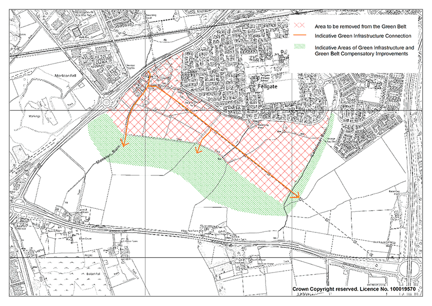
In accordance with the Plan’s chosen spatial strategy and housing distribution, Land south of Fellgate has been identified as a suitable and sustainable urban extension. This strategic allocation represents a unique opportunity within South Tyneside to deliver an exemplary new community which will deliver a range of housing and infrastructure for residents and embed sustainable development principles through the site.
Due to the scale and opportunity for development, the council will produce a comprehensive masterplan and design code in the form of a Fellgate Sustainable Growth Area Supplementary Planning Document. The document will set out the design principles and guidance for the Growth Area to ensure the delivery of an attractive and sustainable location.
To support this allocation the Green Belt boundary in the Fellgate area will be amended through the Local Plan. The South Tyneside Exceptional Circumstances paper demonstrates that exceptional circumstances exist for releasing land from the Green Belt release.
The boundary for the allocation has been informed by the South Tyneside Green Belt Study (2023), which is an independent assessment of the ‘harm’ of releasing land from the Green Belt to accommodate potential development needs. It concludes the least harm to the Green Belt is at the northern edge of the land parcel adjacent to the urban area.
The Growth Area shall provide a new, well-defined and robust boundary will bolster the permanence of the remaining Green Belt and provide a more robust barrier to future encroachment. This will be achieved through the master planning of the site that will be set out in the Fellgate Sustainable Growth Area Supplementary Planning Document.
Green and Blue Infrastructure should be provided throughout the Fellgate Sustainable Growth Area and complement enhancements through the remaining Green Belt identified as compensatory Green Belt improvements. Compensatory improvements to offset the loss of land from the Green Belt may include woodland planting, landscape and visual enhancements, improvements to biodiversity. Potential mitigation and enhancement measures for the Green Belt allocations are outlined in the South Tyneside Green Belt Study (2023) and South Tyneside Green and Blue Infrastructure Strategy (2023).
Green-Blue infrastructure provision will be expected to include new or enhanced walking or cycling routes, children’s play facilities and improved access to new, enhanced or existing recreational and playing field provision. Open space provision and playing pitch requirements should be provided in accordance with the Council’s most recent Open Space Study and Playing Pitch Study.
The Fellgate Sustainable Growth Area will provide approximately 1200 homes. To maximise the delivery of homes within the identified developable area and sustainability credentials, it is anticipated that units will be delivered at higher densities close to the public transport network and the proposed local centre.
The site will also deliver a mix of housing types and tenures, including approximately 300 affordable units and opportunities for self-build homes where appropriate. The Strategic Housing Market Assessment (2023) recommends a split of 25% affordable home and 75% market homes. However, the SHMA recognises that this will be subject to viability testing. The Local Plan Viability Testing Report (2023) concludes that 25% affordable housing provision for this site is sustainable.
A new local centre shall be provided to serve both new and existing communities in the area through the location of community services, local scale retail, food and drink, schools and opportunities for a health care provision. The Local Centre is to be located to coincide with sustainable transport routes, accessibility to the existing Fellgate estate and the green infrastructure network. An assessment of the likely education requirements for this site by the Council has indicated that the site should make provision for land to accommodate a new primary school. The Council is also working with partners to assess potential options for health provision.
Enabling and delivering sustainable travel is a key objective in the delivery of this site and it is essential that active travel options are embedded with the development from the outset. The Sustainability Accessibility Review (2021) states that, given the site is currently greenfield, pedestrian connectivity is currently poor. There will need to be a step-change in connectivity for pedestrians and cyclists. Development proposals will demonstrate how the ability to travel by foot or cycle will be actively encouraged by the delivery of well designed, safe, and convenient access to the site and also through the site. Both existing and proposed walking and cycling routes in the Local Cycling and Walking Infrastructure Plan 2021 - 2036 must demonstrably be taken into account.
In addition to creating new connections throughout the site, it is also important the Growth Area is well connected to the existing Fellgate estate, its infrastructure and public transport connections. Fellgate Metro station is a key asset in terms of supporting and encouraging public transport use for the Fellgate Sustainable Growth Area. The Sustainability Accessibility Review (2021) states that the most direct walking route from the development to Fellgate Metro station would be to the north of the site travelling via Durham Drive or winding through the estate via a series of footways and footpaths. The distance from the north of the site to the Metro Station is approximately 800m. Durham Drive provides a surfaced link with street lighting, a 20mph speed restriction, making it suitable for both cyclists and pedestrians. Upgrading it to cycle infrastructure design LTN 1/20 standard will enhance its suitability and accessibility to the Metro Station.
Where possible, new sustainable transport routes should not only connect the new site to the existing residential area, but also to the wider area and where possible support connectivity into the wider area and neighbouring authorities.
The Sustainable Accessibility Review (2021) recommended that western road access to the site is achieved from The A194 / Mill Lane junction and northern road access from Durham Drive. Details of all necessary on and off-site highway works and improvements, together with a timetable for their implementation, shall be agreed with the Council as part of the comprehensive masterplan and any future planning applications.
The Local Plan has been supported by transport modelling of the strategic road network to understand the potential impacts of the Fellgate Growth Area, particularly on the White Mare Pool Roundabout. This work has been undertaken in partnership with National Highways. The Infrastructure Delivery Plan and associated delivery schedule sets out the improvements required to White Mare Pool roundabout and the wider strategic road network. The joint modelling produced by South Tyneside Council and National Highways identifies that major improvements to White Mare Pool Roundabout will need to have been implemented by 2030 and southbound lane gain at Lindisfarne will need to be implemented by 2035.
The Fellgate Growth Area is located within close proximity to two Local Wildlife Sites (LWS), the Lakeside Inn LWS to the north- west boundary and Calf Close Burn LWS to the eastern boundary. These designations should be protected in accordance with the Local Plan policies and where possible improvements sought for the enhancement of these sites through appropriate mitigation and compensation. The site is also identified as being part of a strategic wildlife corridor. As stated in policy SP8, environmental enhancements to the wildlife corridor should be sought to minimise impacts from the development.
The delivery of Biodiversity Net Gain (BNG) should be delivered in accordance with the locational hierarchy established in Policy 35. Where possible, appropriate BNG should be delivered on-site, however off-site delivery within the identified wildlife corridor network would be supported.
Appropriately designed SuDs should be incorporated into the development in accordance with the 4 pillars of SuDs design in order to protect water quality, control water quantity and improve the amenity and biodiversity value of the area prior to discharge into the nearby watercourses. The North East Lead Local Flood Authorities’ SuDS standards should be followed in the approach to SuDS design within the development.
Monkton Burn and Calf Close Burn should be the discharge locations for any surface water from the site. Proposals should also incorporate an appropriate buffer to both Burns for access and maintenance.
Regeneration Areas and Sites
The borough has a rich industrial heritage, but the Council recognises the reality that traditional industries such as shipbuilding and coal mining no longer underpin the local economy. The objectives for this Plan include supporting regeneration opportunities in urban areas to address the legacies from the borough’s industrial past. As set out in the Spatial Vision, the Council, working with Partners, wants to transform key regeneration sites into vibrant locations for new homes, shops, and jobs.
Policy SP9: Strategic Vision for South Shields Town Centre Regeneration
To create a vibrant and sustainable location for residents, businesses and visitors, South Shields Town Centre will be enhanced and improved by:
- Diversifying the town centre through bringing vacant floor space back into use, utilising upper floor space, encouraging private and public sector investment with an increased leisure and food and drink offer
- Increasing the town centre residential population by delivering new homes in sustainable locations
- Supporting the Tyne Coast College Campus’s relocation into the town centre
- Providing easy access to transport links and parking and improve pedestrian circulation and connectivity around the retail centre.
- Supporting improvements to allow the town centre to become a more vibrant shopping centre
- Supporting improvements to the town’s gateways to make them more appealing and accessible to cyclists and pedestrians.
South Shields is a town with a rich and vibrant history, having been at the forefront of the industrial revolution. The town centre lies between the River Tyne, the historical heart of industry, and the Foreshore, an important coastal attraction. Over the last decade, South Shields town centre has undergone significant investment with new developments including a new transport interchange, The Word, South Shields Job Centre Plus Office, Nexus Learning Centre and investment in the historic marketplace.
Despite investment in the town centre’s infrastructure and public realm, the town centre is facing the same challenges as others around the country. The retail landscape has fundamentally changed over the last decade with the rise of online shopping resulting in reduced footfall on the high street. The South Shields Town Centre Vision Masterplan document (2023) recognises that the town centre must evolve to respond to these challenges and opportunities.
The Masterplan Vision’s critical objectives include increasing footfall in the Town Centre, improving the quality of public realm and increasing the overall number of people living within the Town Centre. Encouraging a wider food and drink offer will be important to diversify the town centre and increase footfall given the change in the retail landscape.
The relocation of the Tyne Coast College into the town centre is an important opportunity to increase activity along King Street, Barrington Street and Chapter Row and to provide a high-quality townscape and public realm which will contribute to the overall character of the Town Centre.
The delivery of new homes in sustainable locations will be supported to help increase the overall town centre population. Policy SP4 allocates 6 sites in the Town Centre with the capacity to deliver approximately 142 new homes. Development proposals for new homes should include high quality and diverse design, a range of homes to suit every age and income level and improved quality and increased diversification of housing.
Public realm works such as de- cluttering, improved wayfinding, public art, and hard and soft landscaping improvements have the potential to create a vibrant array of activities and installations and make the town a vibrant and attractive destination.
SP10: South Shields Riverside Regeneration
Policy SP10: South Shields Riverside Regeneration Area
To achieve an active and vibrant South Shields Riverside that contributes to the prosperity of the borough, the following sites are allocated:
- Holborn Middle Dock and Windmill Hill will deliver a mixed- use residential (approximately 299 homes) and office development. Development proposals shall include the creation of a new promenade that allows public access to the riverside area
- Harton Quay will deliver a mixed- use development which builds on the distinctive characteristics of Mill Dam Conservation Area
- The area surrounding the Customs House will deliver cultural-related uses which complement the use and setting of the Customs House.
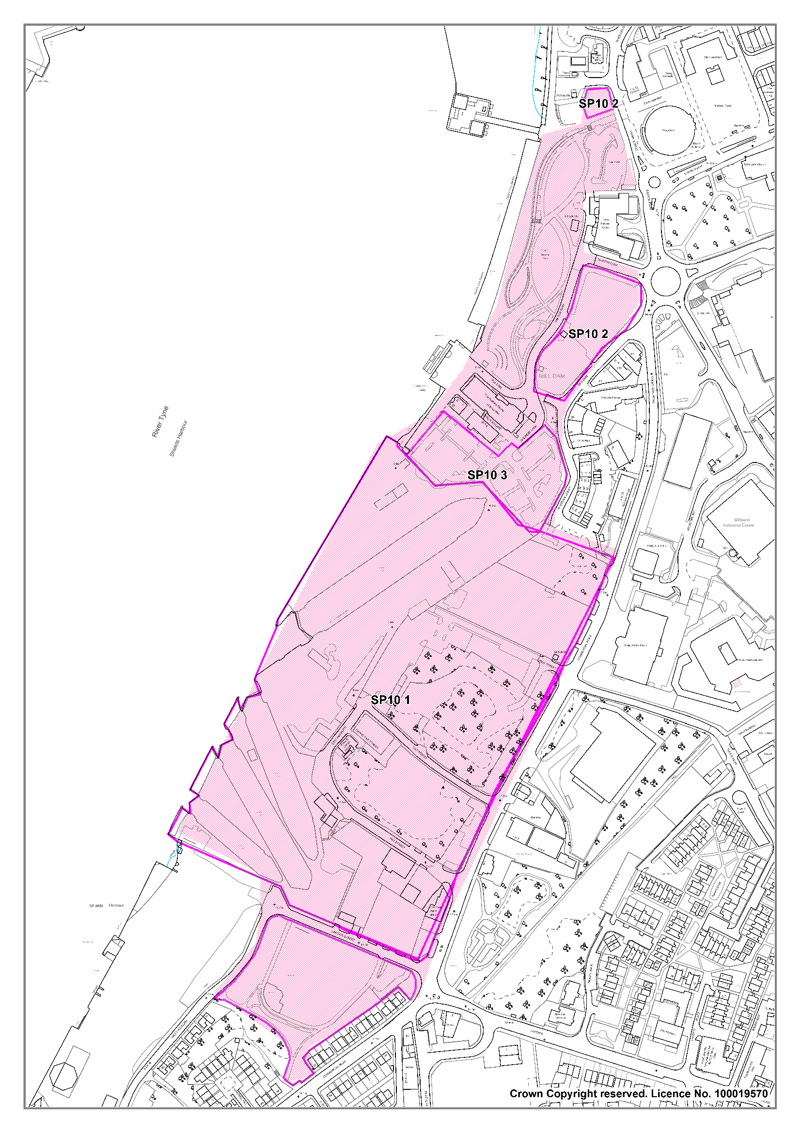
The South Shields Riverside is a major asset to the borough which presents both opportunities and challenges. The allocation of the sites that together make up the Riverside Regeneration Area will contribute to the regeneration of the river corridor and support the on-going regeneration of South Shields Town Centre. It is important that the development of these sites is of a design quality that reflects the Council’s aspirations for the high-quality regeneration of the riverside corridor and that they achieve a high level of permeability for pedestrians and cyclists throughout the South Shields Riverside area and to South Shields Town Centre.
As a regionally significant site, Holborn Middle Dock and Windmill Hill is being brought forward as a flagship mixed-use development. The proposals will bring forward new mixed-use development on the riverside which will not only enhance the waterfront but also mirror investment on the north banks of the Tyne around Tyne Commission Quay / Royal Quays and Smiths Dock. The Council’s proposed investment will complete the regeneration of this stretch of the riverside and will have a major impact in changing perceptions of South Tyneside. This is particularly important given the increasing number of visitors and cruise ships making the river our international window to the world.
The Riverside sites have strong historical associations with the heavy industries that were once prevalent along the River Tyne. They include the remnants of Cookson’s Glassworks and the Staithes Masters House that both contribute to the understanding of the importance the Harton Quay site has played throughout history, just as all the other heritage assets within and around Mill Dam Conservation Area have shared a variety of historical associations. Development proposals should therefore seek to knit what is currently a somewhat disjointed area back together whilst ensuring the many and varied heritage assets remain centre stage, having regard to distinctive views and settings.
The Mill Dam Conservation Area was designated in 1981 and represents an area of riverside heritage which includes the Customs House (1863). Supplementary Planning Document No 19: Mill Dam Conservation Area Management Plan (2010) encourages the Local Authority, developers, development professionals and the local community to engage in the preservation and enhancement of the historic environment. Potential mitigation measures have been highlighted in the Heritage Impact Assessments.
Policy SP11: South Shields Town Centre College Regeneration Site
The relocation of the South Tyneside Campus of Tyne Coast College and the South Shields Marine School into South Shields town centre will be supported. Development proposals shall:
- Provide for a new college campus building
- Support high quality public realm improvements around the new campus buildings
- Respect and respond to the setting of Listed Buildings
- Take account of servicing and access for existing businesses
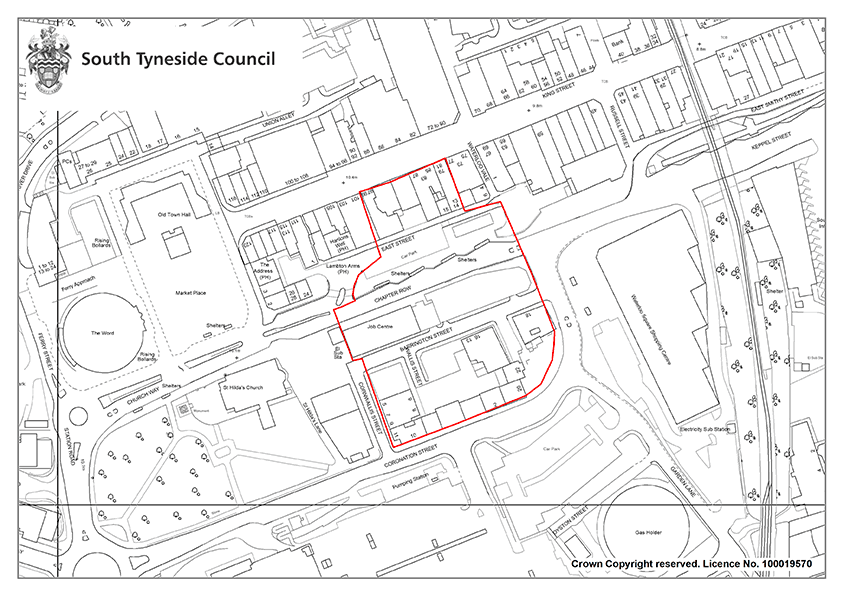
South Tyneside College is a specialist in the provision of marine and offshore skills. The South Tyneside Economic Recovery Plan (2020) states that the Council will work closely with South Tyneside College to develop a fit for purpose College of the Future. The relocation will provide an opportunity for the creation of new state-of- the-art educational facilities that further the Council’s ambitions for making South Tyneside a UK- leader in low-carbon, advanced manufacturing, and digital training that upskills residents and attracts new businesses to the borough. The relocation will also bring students into the heart of the town centre, increasing footfall and thereby supporting its viability and vitality.
The proposed new college campus will be located on a key site in the heart of the Town Centre, close to the Transport Interchange, Barrington Street and King Street. Bringing an important new use into the Town Centre will increase footfall and help support existing and new businesses.
The new college campus will provide a new focal and social hub for the town centre for students, residents and visitors. Development proposals should create a strong frontage to King Street and improve the public realm around the new campus buildings.
Careful consideration of layout height, massing, landscaping, and materials should ensure development contributes positively to this town centre location. Central to the proposed campus is the Grade II Listed 16 Barrington Street, which will be integral to the design process. The immediate setting of the Trustee Savings Bank will also be carefully considered.
Policy SP12: Fowler Street Improvement Area
- The Fowler Street Improvement Area will be enhanced by:
- Supporting the conversion of upper floors of commercial properties for residential use;
- Supporting the introduction of public art;
- Providing student accommodation to support the new Town Centre college campus
- Increasing the residential population by providing new homes.
- Addressing the over-supply of retail units in area and supporting the move towards a more sustainable core
- The following sites are allocated to support the enhancement of the Fowler Street Improvement Area:
- Winchester Street Site is allocated for approximately 35 homes
- Land to the rear of Fowler Street is allocated for approximately 40 homes.
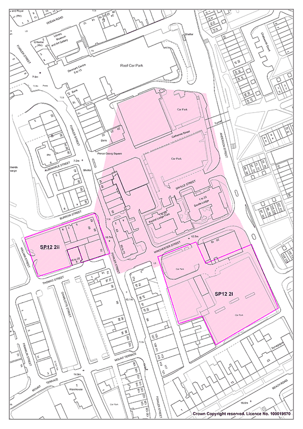
Fowler Street has a mix of commercial premises and several attractive historic properties. The relocation of the library from Prince Georg Square has left a large vacant site in this key gateway location. Fowler Street is an important route into the Town Centre for both buses and pedestrians however landscaping along this route is currently limited. The Council will support proposals that complement the existing townscape features, improve the quality of the built environment and bring vacant floor space back into use.
There are currently a variety of uses within the Winchester Street site with the predominant one being a car park. There is an opportunity here to provide new homes in a location which will support the vitality and viability of the town centre. Although the site does not directly front onto Fowler Street, its proximity to this High Street means that it is particularly important that the quality of the development acknowledges the Council’s positive aspirations for the regeneration of the town centre.
Policy SP13: Foreshore Improvement Area
- Development of leisure and tourism offer within the identified Foreshore Improvement Area will be supported by:
- Public realm improvements and the development of visitor, recreation and leisure facilities at Gypsies Green and the surrounding area;
- Public realm improvements at the promenade between Colmans Seafood Temple and Trow Quarry;
- The creation, enhancement and expansion of tourist attractions and visitor accommodation and infrastructure.
- Proposals shall have regard to the Shoreline Management Plan, particularly in respect of the potential for the shoreline to be rolled-back in future years due to coastal erosion.
- Proposals shall have regard to flood risk and also to the requirements for a HRA where impacts on European sites may occur.

The South Shields Foreshore area is an important tourism resource. The parks and beaches represent one of the North East’s premier coastal attractions and it is the key driver for the borough’s visitor economy. The Council has an ongoing commitment to further strengthen these vital assets through investment in the area’s public realm and facilities. This commitment has already paid dividends. For example, the Littlehaven Promenade regeneration has redefined the northern stretch of the Foreshore.
Regarding the further investment identified in the policy, Gypsies Green Stadium accommodates a diverse range of user groups including South Shields Harriers & Athletics Club, South Shields Velo Cycling Club and South Tyneside Football Club. The Council is in discussions with Partners and existing users about the redevelopment of Gypsies Green as a visitor, recreation and leisure hub. The Council is also seeking funding for the south promenade / Gypsies Green area. The public realm along most of the promenade has been improved but continued investment in the promenade to the south between Colmans Seafood Temple and Trow Quarry will increase usage and maximise the potential of the area.
As set out in Policy 25, Leisure and Tourism, proposals that enhance the range and quality of visitor attractions and facilities along the Foreshore will be supported and well as proposals for water-based leisure and recreational resources.
North East Inshore and North East Offshore Marine Plan (2021) policy NE-TR-1: Tourism and Recreation promotes and sustainable tourism and recreation activities in coastal areas. Where relevant, proposals should consider this policy alongside the plan policies.
As well as being an attractive area for tourism and leisure, the Foreshore area is in close proximity to sensitive and important Habitats sites and wildlife areas. Any redevelopment works along the coastline must demonstrate that they will not result in adverse impacts on the adjacent designated sites (SPA/Ramsar/SSSI). Proposals in this area will be considered against Policy 34 of this Local Plan for any likely significant effects on the Habitats sites. Applicants are encouraged to engage in early discussions with the council for development proposals within this area.
Development close to the coast should consider the unique character, quality, and distinctiveness of the area, particularly in relation to Seascape. Seascape considers more than just views of the sea surface and/or coast: it reflects the community’s personal connectivity with coastal and marine areas. Development proposals should consider the Marine Management Organisation (MMO) ‘Seascape Character Assessment for the North East Inshore and Offshore marine plan areas’ (2018), and the North East Inshore and North East Offshore Marine Plan (2021) Seascape Policy NE-SCP-1.
The Shoreline Management Plan identifies the need to retreat the coastline at this location due to climate change and rising sea levels. As there is a hard barrier currently behind the beach in this location, the dunes cannot naturally retreat inland. Development proposals should take into account the need to manage the retreat of the dunes to create a more natural flood barrier and to maintain the amenity value of the beach.
Economic Allocations
It is important to ensure that there is a portfolio of available sites across the borough which are attractive to new employers, allows the expansion of existing businesses and responds to the changing needs of businesses. It is essential that these are in areas that offer good opportunities to attract investment.
Policy SP14: Wardley Colliery
12.7 hectares of land, as defined on the Policies Map, is allocated at Wardley Colliery for general economic development and will be removed from the Green Belt.
- In taking forward the economic development component, development proposals must:
- Ensure they do not prejudice the implementation of the full 12.7 hectare allocation for employment development
- Ensure that adverse ecological impacts are dealt with through the mitigation hierarchy and are delivered within Wardley Colliery Local Wildlife Site
- Include compensatory improvements to the environmental quality of remaining Green Belt land to offset the impact of the removal of the land from the Green Belt.
Wardley Colliery is a former coal processing and disposal site that was operational in the early 1990’s. Since that time is has been occupied by several uses. Currently part of the site is used for container storage, part is hardstanding, and the site also includes an anaerobic digestion plant which generates renewable energy through the treatment of by-products from the food industry. The site comprises previously developed land.
The site is not suited to meeting the specific qualitative need that has been identified for a new business/ industrial park. However, it has the potential to make a significant contribution to the supply of employment land.
The site is near the A184 / A194 junction, a key strategic junction, and lies adjacent to the Leamside Line which the Council and its Partners are looking to re-open. It therefore offers an excellent opportunity for businesses that would require first class transport links and that are able to operate effectively within this distinctive site.
It is considered that the test of exceptional circumstances has been met for the release of land for economic development purposes from the Green Belt.
The South Tyneside Green Belt Study (2023) identifies potential mitigation measures that may reduce the potential harm to the Green Belt. It also identifies opportunities for the enhancement of remaining Green Belt to compensate for release and these have been incorporated into the Site Framework document.

The site is within an area requiring further investigation in relation to contamination, with former uses including a colliery and strategic coal stocking site. Surface water flooding has been identified on some small areas of the site.
The Wardley Colliery Local Wildlife Site is the largest open mosaic habitat on previously developed land in South Tyneside and is the most valuable example of its type in the borough. The NPPF is clear on the desirability of conserving and enhancing nature conservation.
A small area of the Local Wildlife Site falls within the employment component of the site but has been identified as within the employment component because it also falls within an area consented for employment use. This does not alter its Local Wildlife Site status, but this specific area of the Local Wildlife Site falls out with the Green Belt.
The total area of land that is allocated for employment is 12.7 ha. The available area (i.e. the area net of existing development) is 6.71 ha (this makes allowance for the area used for container storage and the Anaerobic Digester that has been built.
Land to the north of Follingsby Lane, within the ownership of Thomas Armstrong, is safeguarded for a train/metro station in Policy 52: Safeguarding Land for Metro and Rail Development.
Promoting Healthy Communities
The planning system can play an important role in facilitating interaction and creating healthy, safe, and inclusive communities. This Plan seeks to embed health and wellbeing considerations throughout to achieve healthy places with safe, accessible, and inclusive environments for people to come together. It is also important to deliver the social, recreational, and cultural facilities and services that communities need to facilitate active and healthy lifestyles such as through the provision of appropriate green infrastructure.
The policies within this chapter seek to deliver the aims of Local Plan Strategic Objective 2.
Policy 1: Promoting Healthy Communities
The Council and its partners, including the NHS, will seek to improve the health, wellbeing and quality of life of South Tyneside residents, reduce health inequalities and to help people live longer and healthier lives. This will be achieved by:
- Supporting new development which:
- Increases opportunities for physical activity and active travel through the provision of good quality sport and recreation facilities and safe and accessible walking, cycling and public transport networks.
- Promotes safe and sustainable public realm and residential environments that encourage social interaction, and cohesive and vibrant communities
- Enhances the green and blue infrastructure network and supports climate change mitigation and adaptation.
- Ensure that pollutants, including noise and air pollution, and hazards detrimental to public health and residential amenity are addressed prior to development
- Delivering well-designed and high-quality housing to meet the needs of the borough’s population
- Supporting initiatives to reduce inequality and contribute to job creation, education and training opportunities within South Tyneside
- Managing the provision of hot food takeaway outlets and promote and encourage healthy food choices to reduce levels of excess weight
- Supporting the delivery of health care provision and improvements
- Requiring new major developments to contribute to improving health and reducing health inequalities by requiring a Health Impact Assessment (HIA) to be submitted for:
- Residential schemes for 100 or more dwellings
- Non-residential developments over 1 hectare in size
The built and natural environment can have a significant impact on physical and mental health of residents. Improving the health and wellbeing of our communities and reducing health inequalities in South Tyneside are key priorities for the Council. Planning can play a significant role in providing healthier environments by engaging with communities and providing access to health care facilities and well-designed public, commercial and residential spaces. Well-designed spaces can also provide opportunities for active and positive health-related behaviours and tackle social isolation.
The health of South Tyneside residents is generally worse than the local and national average. South Tyneside Alliance have several health priorities that they have made a commitment through ‘Our South Tyneside Vision’ (2022) to ensure residents live happy, healthy, and fulfilled lives. The Joint Health and Wellbeing Strategy for South Tyneside (2022) also outlines plans to tackle the significant health challenges through ‘Giving each young person the best start in life, Creating health places for residents to live, learn and work, Ensure good mental wellbeing and social connectivity and Create financial security’.
The built environment contributes to the wider factors which are influential in promoting or discouraging physical activity. Poor quality, unsafe environments which limit access to recreational spaces and facilities or prioritise the private car over other modes of sustainable transport can discourage the amount of physical activity untaken. Lack of physical activity and other unhealthy behaviours can lead to increased levels of obesity and other health issues which can reduce life expectancy and increase health inequality.
Good quality open space are important assets in facilitating physical activity and healthy behaviours. Green spaces and the natural environment provide important areas for social interaction which can reduce loneliness amongst all ages and promote good citizenship. The Covid-19 Pandemic has highlighted the vital role that areas of natural environment and greenspace provide to our communities in terms of physical health, providing opportunities to exercise and be active and providing mental wellbeing benefits. These areas are spaces which are valued by residents and provide an important community function and can make a significant contribution to quality of life.
Allotments and community orchards provide opportunities for outdoor recreation and to produce healthy locally grown food, which can help to improve the diet of residents. Climate change could also negatively affect human health i.e. heat waves, flooding; nature- based mitigation solutions can help to lessen the health impacts.
New developments can generate potential risks to human health through increasing exposure to air pollution, noise pollution or contaminated land. These issues should be adequately addressed and assessed in accordance with the relevant policies in this Plan.
Long term unemployment and poor housing can have negative impacts on the health and well-being of individuals and in turn, poor health can lead to economic inactivity. Planning can contribute to closing the gap in health inequality and improving quality of life by ensuring access to local healthcare facilities and providing well-designed developments that are accessible to all. Encouraging opportunities for employment, education, and training, as well as provision for culture and recreation can also contribute to improving mental health amongst residents.
The borough’s health facilities are likely to come under pressure due to an ageing population and health facility capacities. The Council’s Planning and Public Health teams are working in Partnership with South Tyneside Integrated Care Board (ICB) to support health care provision and improvements to ensure that healthcare provision is accessible to all.
Housing has an essential role to play in good health and wellbeing across all life stages. Housing that is poor quality, in poor state of repair, or that lacks basic facilities can have a detrimental impact on residents’ physical health and mental wellbeing. Despite continued improvements in construction standards, the home remains a major cause of ill health for many. Poor quality housing can increase the risk of injury, cause or exacerbate respiratory and cardiovascular diseases and can cause illness or even death from temperature extremes. It is important that these risks are minimised and prevented, ensuring residents have suitable housing that meets their needs. Making sure that households have access to good quality housing options, particularly residents who may be more vulnerable to ill health, for example older households and those with young families, is essential to creating healthier communities.
The South Tyneside Local Plan seeks to ensure that positive opportunities from development are achieved and that any unintended consequences do not disproportionately impact upon the population, especially those more at risk from health inequalities. To ensure that health impacts are considered at the very outset, a Health Impact Assessment (HIA) shall be submitted in support of major planning applications of a scale where a HIA could enhance, and support health benefits associated with the development. Undertaking a Health Impact Assessment (HIA) will allow applicants to demonstrate that their proposal will not have negative implications for the physical health and mental wellbeing of existing communities in the vicinity, as well as the future residents of the new development.
As South Tyneside faces significant health challenges inequalities across the borough, Health Impact Assessments will allow new developments to consider and understand the local community health needs and inequalities and demonstrate how it can support these. The Health Impact Assessment should be proportionate to the scale of development proposed. Where a submitted Health Impact Assessment indicates that a development would have a significant adverse impact on health and wellbeing, development will be resisted unless evidence is submitted to demonstrate to the Council’s satisfaction that the impacts can be adequately mitigated. Further guidance on what detail should be contained within an HIA will be set out within a developer guidance note.
Air Quality
Policy 2: Air Quality
- Development will be supported where it contributes to the improvement of air quality.
- Where significant air quality impacts are likely to be generated by the development, an appropriate air quality assessment will be required.
- Development that would result in exposure to air pollution that exceeds national air quality objectives will only be approved where satisfactory mitigation measures can be implemented.
Air pollution is associated with several adverse health impacts and particularly affects vulnerable groups such as children, older people and those with heart and lung conditions. The importance of good air quality is recognised by the World Health Organisation which produced a series of standards that have been adopted by the European Commission and subsequently the UK.
The planning system can play an important role in the improvement of air quality. Whether or not air quality issues are relevant to a planning decision will depend on a proposed development and its location. In determining a planning application, a development’s likely effect, either directly or indirectly, on air quality will be considered.
The Local Air Quality Strategy and Action Plan for South Tyneside (2023) sets clear objectives for driving down levels of pollutants and improving local air quality. The Air Quality Strategy recognises that development in the borough has the potential to impact air quality and supports policies which ensure new developments do not lead to further deterioration of air quality.
The Air Quality Annual Status Report (ASR) (2021) provides an overview of air quality in South Tyneside. The Council reviews Nitrogen Dioxide (NO2) annually so that any changes can be identified, and action taken where air quality exceeds national targets. The principal source of NO2 is road transport, combustion processes such as power generation and industrial processes. As highlighted in the ASR, the main contribution in South Tyneside is from road traffic.
Where relevant, development that may result in a detrimental effect on air quality in the borough will need to be supported by an air quality assessment that demonstrates appropriate mitigation or promotes sustainable options such as electric charging points. Development proposals must consider the cumulative impacts from other permitted developments on air quality. The Validation Checklist outlines what an Air Quality Assessment must include.
Pollution
Policy 3: Pollution
- Development that may cause pollution of water, soil, or air through noise, vibration, odour, light, fumes, dust, or other pollutants, either individually or cumulatively, shall incorporate measures to prevent or reduce pollution to an acceptable standard to avoid negative impacts on people, the environment or biodiversity.
- Development which could lead to significant pollution, either individually or cumulatively, shall be accompanied by a detailed assessment of the likely impacts. Development proposals where pollution levels are assessed as being unacceptable will only be permitted where mitigation measures can be introduced to provide an acceptable living or working environment in relation to all existing or potential future occupants of the land.
- Where the Council considers it likely that the proposal will result in significant adverse environmental effects during the construction phase a Construction Environmental Management Plan (CEMP) will be required.
Planning has an important role to play in making sure that new and existing development does not have, and is not at risk from, pollution which could have an unacceptable impact on health, living conditions or the natural environment including water quality. The NPPF sets out that new development needs to be appropriate for its location and must consider the likely effects of pollution on health and living conditions including the sensitivity of the site itself and the wider area to those impacts. This is to ensure that new development can be integrated effectively with existing businesses and other community facilities (such as places of worship, pubs, music venues and sports clubs).
Pollution is the release of substances into the environment that can cause harm to human health, property and any other living organism supported by the wider environment. New and existing development should be protected from unacceptable levels of pollution and should not contribute to any increase in pollution.
Pollution considerations are especially important when planning for housing, day centres, schools and in areas of high population density. The separation of sensitive developments such as residential, or those relation to health and educational, from polluting sources can reduce the detrimental effects of pollution on those uses. Development that may be sensitive to existing or potentially polluting sources will only be permitted at an acceptable distance from such sources or where satisfactory mitigation measures can be demonstrated.
Where development could lead to significant pollution, either individually or cumulatively, proposals must be supported by detailed assessment of the likely impacts. Development will be supported where such assessments demonstrate that pollution can be mitigated and brought within acceptable levels. Acceptable levels refer to statutory limits and the wider considerations of impacts under the Environmental Protection Act (1990).
Noise assessments will be required for any development proposals that will either introduce a noise source or create a sensitive use in proximity to an existing noise source. Mitigation measures to minimise adverse impacts from noise pollution should be considered and submitted with development proposals. Consideration should be given to the World Health Organisation levels for community noise.
Contaminated Land and Ground Stability
Policy 4: Contaminated Land and Ground Stability
Development proposals that would be affected by contamination or ground stability issues or where contamination may present a risk to the water environment shall:
- Carry out investigations to assess the nature and extent of contamination or ground stability issues and the effect this may have on the development and its future users, biodiversity, the natural and built environment
- Set out detailed measures, as appropriate, to allow the development to go ahead without adverse effect. These may include:
- Removing the contamination
- Treating the contamination
- Protecting the development from the effects of the contamination
- Validation of mitigation measures
- Addressing land stability issues.
South Tyneside has a significant industrial heritage that includes ship building and coal mining. Modern industries in the borough include an active port, small chemical plants, quarrying and petrol storage. However, these have potentially introduced contamination and instability to the land. Depending on the level of contamination or land instability from previous uses, these sites are often incapable of being brought back into beneficial use without treatment.
The presence of contamination can restrict the viable reuse of a site and failure to adequately deal with land contamination could cause harm to health, property, and the wider environment. However, development can address the problem and bring land back into beneficial use. The presence of land instability can be a concern when new development is proposed, and it is necessary to ensure that new development and its surroundings are safe for future users.
All new development with a sensitive end use (including dwellings, allotments, schools, nurseries, playgrounds, hospitals and care homes) requires a minimum of a Phase 1 Land Contamination Assessment (often referred to as a Preliminary Risk Assessment) to be submitted. Also new development on land that has been identified on the public register as being contaminated, or land that is adjacent, requires a Phase 1 Assessment as a minimum.
Any potential risks associated with contaminated land and land instability should be identified and assessed at the earliest opportunity. Where necessary, applicants will be required to carry out remediation works so that their development can take place without any negative impact or risks to human health or the environment.
South Tyneside’s Contaminated Land Strategy (June 2019) provides the process whereby detailed inspection of land will be carried out and a risk assessment completed to determine whether land meets the definition of ‘contaminated land’ according to the legislation. The Strategy emphasises the importance of the planning regime in addressing potentially contaminated sites and ensuring that they are remediated to a condition that is suitable for their intended end use.
In assessing whether land contamination or land instability is an issue to be considered when a planning application is submitted, the Council will have regard to a range of information sources including that which is provided by developers and third parties as well as the advice of the Coal Authority, Environment Agency, and the Council’s Environmental Protection Team.
Where a site is affected by contamination or land instability, the applicant must submit a report detailing remediation and management measures to deal with risks from site works and health risks for end users. The report should be submitted to the Local Planning Authority as part of the planning application, and the Council will consult the Environment Agency and its Environmental Protections Officers.
The Council has adopted The Yorkshire and Lincolnshire Pollution Advisory Group’s “Development on Land Affected by Contamination; Technical Guidance for Developers, Landowners and Consultants”. This can assist applicants who intend to develop or redevelop potentially contaminated land.
The guidance is made up of three documents: Planning Guidance, Verification requirements for cover systems, and Verification requirements for gas protection systems. There is also a screening assessment form which is used for developments where it may only be a single house build or low risk development.
Meeting the challenge of climate change, flooding, and coastal change
One of the biggest challenges the borough is facing during the lifetime of this plan is the climate emergency and the need to meet the significant rise in electricity demand that will arise from the move away from using fossil fuels to supply power for homes and vehicles.
The world is warming because of increased greenhouse gas emissions largely compounded by economic and population growth driving demand for the earth’s natural resources. The impacts of climate change on the built and natural environment are occurring globally, nationally, and locally. Such effects include higher temperatures especially during the summer months, increased rainfall and flooding during the winter months and an increase in extreme coastal water levels driven mainly by increases in mean sea level rise.
The government has introduced legislation which commits the UK to becoming net carbon zero by 2050 through amendments to the Climate Change Act 2008. At a local level, South Tyneside Council declared a Climate Change Emergency in 2019, which commits the Council’s operations to becoming carbon neutral by 2030 and a move towards the use of cleaner, greener, renewable sources of energy.
Planning has an important role in the delivery of new renewable and low carbon energy infrastructure subject to local environmental impact. The NPPF sets out a positive approach to securing radical reductions in greenhouse gas emissions. It is made clear that decisions should be taken in line with the 2008 Climate Change Act, which has the provision to reduce carbon dioxide emissions by 80% by 2050, albeit there is no quota which the Local Plan has to deliver. The NPPF also states that development should avoid increasing vulnerability to a range of impacts arising from climate change including flood risk, coastal change, water supply and changes to biodiversity and landscape.
The policies in this chapter reflect aim to deliver Strategic Objectives 3 and 4 which include:
- Contributing to the reduction of carbon emissions.
- Maximising opportunities for renewable energy generation and sustainable construction.
- Promoting resilience to the effects of climate change and the use of nature-based solutions
- Minimising and mitigating flood risk
Climate Change
Policy SP15: Climate Change
To meet the challenge of mitigating and adapting to the effects of climate change, a comprehensive approach to delivering sustainable development and reducing carbon emissions is required. This will be achieved by:
- Improving the climate resilience of communities and environments to the effects of climate change
- Requiring development to reduce carbon emissions by embedding sustainable principles into the design, construction, and operation of developments
- Reducing greenhouse gas emissions through the delivery of low carbon heating networks and renewable energy generation, where appropriate
- Maximising the potential of the natural environment to mitigate climate change by supporting nature-based approaches to mitigation and ensuring net gain for biodiversity
- Facilitating a modal shift in transport by maximising the ability to make trips by public transport, sustainable and active modes of transport, and reducing the desirability and necessity of private vehicle ownership and use
- Supporting urban and peri-urban agriculture.
The South Tyneside Local Plan can make a major contribution to mitigating and adapting to climate change by shaping new and existing developments in ways that reduce carbon emissions and positively build community resilience to problems such as extreme heat or flood risk. It can do this by ensuring that new development reduces the need to travel and supports the fullest possible use of sustainable transport. It should be designed in a way that limits carbon dioxide emissions, uses decentralised and renewable or low carbon energy, and minimises vulnerability to future climate impacts.
The policies within the Local Plan support the Climate Emergency pledge and the delivery of the actions set out in the council’s Climate Change strategy and action plan ‘Sustainable South Tyneside 2020 – 2025’.
Policy SP15 sets the principles for mitigating and adapting to climate change and ensures that large- scale development and associated infrastructure is future proofed and resilient to future impacts. Climate change mitigation is about reducing the impact of human activity on the climate, primarily through reducing greenhouse gas emissions, such as carbon dioxide (CO2); whereas climate change adaptation is about adjusting to the impacts of climate change to lessen harm, e.g. increased flooding protection and adapting to hotter weather.
The Council will be supportive of innovative approaches to meeting and exceeding the standards set out in Local Plan policies to delivering sustainable development and carbon reduction measures.
Achieving sustainable development means that plans should secure net gains in terms of economic, social, and environmental objectives. Our current transportation system is responsible for a significant share of the borough’s greenhouse gas emissions and land use. Nature- based solutions, and approaches to address societal challenges that also protect, restore or enhance nature, can be incorporated into transportation infrastructure. Modes of public transport such as buses and trains, as well as shared forms of mobility such as car shares, are more efficient means of transport with lower overall emissions and/or land-use per person. Active travel, which includes cycling, walking, wheelchair travel and scooting, are the most efficient means of travel (regardless of energy/fuel sources for the above motorised vehicles). To reduce transportation’s environmental footprint, this sustainable travel hierarchy should be followed. This can be through the addition of GBI (Green-Blue Infrastructure) to existing infrastructure, such as green roofs on bus stops, or by shifting towards more space-efficient modes of transport which, if coordinated appropriately, could free up road space and land for parking for more expansive GBI.
Urban agriculture can benefit food security which is likely to be impacted by a changing climate, whilst also bringing the multiple benefits of green infrastructure, including carbon sequestration, carbon emission mitigation, supporting biodiversity, improving air quality, and regulating local temperature and water run-off.
Reducing energy consumption and carbon emissions
Policy 5: Reducing energy consumption and carbon emissions
All development shall embody sustainable design and carbon reduction measures as far as possible, with an emphasis on a whole life carbon approach. Development which achieves zero carbon will be supported.
- Development, including refurbishment, conversion and extensions to existing buildings shall, where applicable, incorporate sustainable design and construction practices including:
- The efficient use of mineral resources and the incorporation of a proportion of recycled and/or secondary aggregates
- The use of sustainable materials, e.g. those with low embodied carbon or renewable materials
- Waste minimisation and reuse of material derived from excavation and demolition
- The use of landform, layout, building orientation, massing, and landscaping to reduce energy consumption
- Water efficiency that meets the highest national standard
- Measures that enable sustainable lifestyles for the occupants of the buildings.
- Development shall follow the energy hierarchy except where it can be demonstrated that greater sustainability can be achieved by utilising measures further down the hierarchy
- Major development, including proposals involving the redevelopment of existing floorspace, shall include a Sustainability Statement outlining their approach to the following issues:
- adaptation to climate change
- carbon reduction
- water management
- site waste management
- use of materials.
- Where it is not possible to meet these standards, applicants must demonstrate compelling reasons and provide evidence as to why achieving the sustainability standards would not be technically feasible or economically viable.
Minimising energy demand and meeting the borough’s demands for heat and power without increasing carbon emissions to assist South Tyneside in meeting its climate emergency commitments is a priority. Policy 5 sets out ways in which development can reduce energy consumption and support sustainable design.
In 2025 compliance with the Future Homes Standard will become mandatory. Its aim is to ensure that new homes built from 2025 will produce 75-80% less carbon emissions than homes built under previous Building Regulations. It will do this by focusing on improving heating, hot water systems, and reducing heat waste. This will be achieved in part by replacing current technologies with low-carbon alternatives.
Energy use in the construction and operation of development is currently a major contributor to greenhouse gas emissions. If South Tyneside is to fully support the achievement of the above targets, then it will be necessary both to minimise energy demands from development and to increase the generation of energy from renewable sources.
The Energy Hierarchy
The Energy Hierarchy offers an effective framework to guide sustainable energy policy and decision-making. It is a classification of energy options, prioritised to assist progress towards a more sustainable energy system.
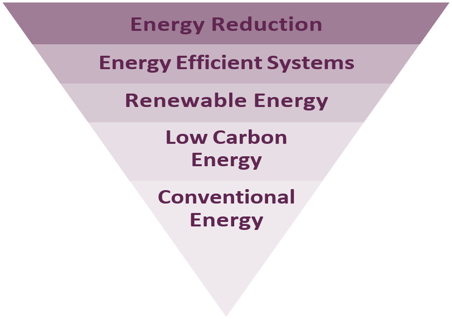
The starting point for minimising energy use is to maximise energy efficiency, both in new developments and through the retrofitting of existing buildings. This can have a direct economic benefit in terms of significantly lowering the running costs of new and existing buildings, helping to address fuel poverty, as well as tackling climate change. Exceeding the minimum energy efficiency requirements of Building Regulations will be necessary if emission reduction targets are to be met.
Where energy use is necessary, priority should be given to utilising the most sustainable sources. Within South Tyneside, the scale and location of development means that there are opportunities to create and connect to district heating networks in parts of the borough, through both new development and the retrofitting of existing buildings. These areas and connection requirements are identified in Policy 6.
Zero carbon development means development where emissions from all regulated energy use are eliminated or offset. Offsets must be verifiable, long term and certified by an approved authorised body. The scenario used to produce the offset requirement must be based on realistic occupancy comfort conditions without significantly widening the deadband, e.g. between heating and cooling setpoints.
Considering operational as well as embodied carbon emissions together over a project’s expected life cycle constitutes the whole life approach. A whole life carbon approach identifies the overall best combined opportunities for reducing lifetime emissions and helps to avoid any unintended consequences of focusing on operational emissions alone.
For whole life principles to be integrated into the design, procurement, construction processes and beyond, and for project teams to be engaged in a timely fashion, carbon assessments should be carried out at key project stages from concept design to practical completion. Appropriate timing and sequencing of carbon assessments will help identify carbon reduction opportunities and monitor a project’s progress in achieving them. Carbon assessment scenarios must use realistic internal conditions for building services e.g. lighting levels, heating, and cooling setpoints, relative humidity, etc.
Refurbishment will be encouraged over demolition. When a building is demolished energy is used to deconstruct it, and remove, process and dispose of the waste. CO2 may also be released through associated chemical processes. Building a new replacement requires more materials and energy, creating more embodied carbon.
The Circular Economy is a system of using resources in a way that designs out waste and promotes the sharing, leasing, reusing, repairing, refurbishment and recycling of products. Good practice would include measures such as building in layers to allow for targeted maintenance, ensuring waste minimisation is embedded in projects from inception to completion, designing for longevity, designing for adaptability or flexibility, designing for disassembly, and using resources that can be reused.
Sustainability Statement
The choice of sustainability measures and how they are implemented may vary substantially from development to development. However, the general principles of sustainable design and construction should be applied to all scales and types of development. The Sustainability Statement should demonstrate how proposals avoid increased vulnerability to the impacts arising from climate change through sustainable and resilient design. The Sustainability Statement should be proportionate to the proposed scale of development and clearly set out, providing sufficient detail on how sustainable design solutions have been integrated for both the construction and operation phases of the development.
Major development consists of 10 or more residential units, or non-residential development with a floorspace of 1,000m² or more. In additional, the Council will consider mixed-use development to be major development where either of the thresholds for major development are met. Non-major or smaller scale development means any development of a smaller scale than major development, including minor and householder development.
Renewables and Low Carbon Energy
Policy 6: Renewables and Low Carbon Energy Generation
- Renewable and low carbon energy development in appropriate locations will be supported where it can be demonstrated that there would be no unacceptable adverse impacts which cannot be satisfactorily mitigated against:
- The built environment including heritage assets
- The natural environment including the water environment, green infrastructure and biodiversity assets, such as designated sites, protected species and priority habitats and species
- Cumulative, indirect, and direct impacts on the landscape and Green Belt
- Neighbouring land uses and developments including adverse impacts on amenity by virtue of noise and visual intrusion
- The incorporation of renewable energy into developments, particularly as part of major schemes, will be supported. The retrofit of renewable energy, use of micro-generation and community energy schemes will also be supported in appropriate buildings and locations.
- New wind energy developments will be supported in areas identified as suitable on Map 15, or where they involve the repowering of existing turbines provided that:
- The location, scale and design of the proposal conform with criteria (3 i-iii) of this policy
- Any unacceptable significant adverse impacts, such as noise nuisance, shadow flicker, overshadowing or overbearing, and interference with telecommunications, air traffic operations and MOD safeguarding areas are satisfactorily mitigated
- Any proposed wind turbine development is subject to Habitats Regulations Assessment and where likely significant effects are identified, permission would be dependent on the assessment ruling out adverse effects on integrity, alone or in- combination.
- Energy networks, enabling the supply of low carbon heat and/or cooling and electricity generation technologies from a central source will be strongly supported and encouraged by:
- Identifying potential district heating networks within South Tyneside
- Ensuring energy networks are scaled and operated to maximise the potential for carbon reduction
- Requiring major developments, via a sustainability statement, to assess the feasibility of connecting to an existing decentralised energy network or, where this is not possible, assess the feasibility of establishing a new network
- The following existing or emerging heat networks are identified on Maps 16, 17 and 18:
- Holborn Renewable Energy Network, South Shields
- Hebburn Minewater Project
- Viking Energy Network, Jarrow
- Developments within 400m of an existing district heat network or an emerging identified heat network shall be designed ready to connect to the district network, unless:
- It can be clearly demonstrated that there is insufficient capacity
- Utilising a different energy supply would be more sustainable
- Connection is not physically feasible.
Wind Energy Development
District Heating Schemes
The NPPF supports the transition to a low carbon future and contributions towards a radical reduction in greenhouse gas emissions. The use and supply of renewable and low carbon energy is an important aspect of sustainable development. Energy from renewable sources makes an important contribution to reducing greenhouse gas emissions which are the main cause of global warming and climate change.
This policy applies to all development proposals for renewable and low carbon technologies as stated in the policy, and proposals for schemes which may include photovoltaics, solar thermal systems and/or air/ground source heat pumps
The NPPF requires Local Plans to increase the use and supply of renewable and low carbon energy and heat by providing a positive strategy that maximises suitable development and identifies suitable areas for these energy sources.
Use of alternatives to traditional fossil fuels is a way to help improve air quality, reduce greenhouse gas emissions and improve energy security. Opportunities to develop the more widespread use of alternative energy sources include supporting emerging technologies and innovations, and supporting the development of supply chains, infrastructure and associated skill requirements. The development of renewable and low carbon energy schemes (including community-led initiatives), together with any ancillary building(s) and infrastructure, will be considered in the context of sustainable development and any impact on the landscape.
The Local Plan does not explicitly identify locations that may be suitable for large scale solar schemes. Applications will be assessed on a case by case basis.
Policy 6 seeks to identify areas potentially suitable for new wind energy development. The areas identified in Map 15 are proposals at this stage. Proposals for wind energy development in these areas would be assessed against national and local policies.
This policy is supported by the South Tyneside Wind Development Study (2021) which identifies potential areas suitable for different turbine heights. Policy 6 will be the primary consideration in the determination of any planning application. This Study should be consulted prior to the submission of any planning application for a new wind turbine.
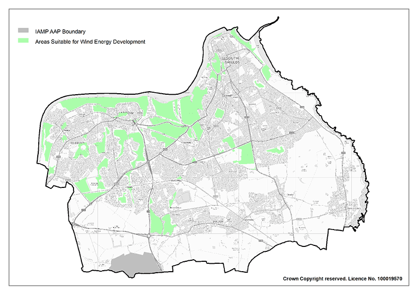
South Tyneside Council is supportive of the use of district heating schemes as a low carbon means of providing energy to new and existing development within the borough. Major developments are required to assess the feasibility of connecting to an existing network or establishing a new network within the development where feasible and viable. Applicants are expected to demonstrate feasibility of this via a sustainability statement submitted alongside a planning application. Where it is feasible that a development could connect to a network identified by the Council or a new scheme could be established, early discussions between the applicant and the Council are encouraged.
The Council has undertaken a heat mapping exercise which identified three locations for district energy scheme in Jarrow, Hebburn and South Shields (Maps 16, 17 and 18). South Tyneside Council is delivering a renewable energy scheme in Jarrow which combines a river source heat pump, a combined heat and power (CHP) back-up system and a 1 MW solar farm. Following the success of first phase district energy scheme at Jarrow, the second phase of the project is being delivered at Hebburn to further expand the heat network infrastructure in the borough. The Council intend to further investigate the feasibility of other district heating networks. Existing and potential district heating schemes should be taken into consideration by development proposals.
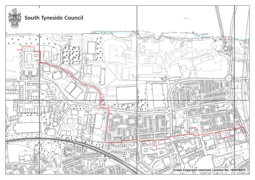
Flood Risk and Water Management
Policy 7: Flood Risk and Water Management
To reduce flood risk and ensure appropriate water management, development proposals shall:
- Follow the sequential approach, directing new development to areas at lowest risk of flooding
- Ensure opportunities to contribute to the mitigation of flooding elsewhere are taken
- Prioritise the use of sustainable drainage systems (SuDs), where appropriate
- Comply with the Water Framework Directive by contributing to the Northumbria River Basin Management Plan
- Maximise the use of permeable surfaces and green infrastructure where practicable
- Not culvert or build over watercourses
- Remove existing culverts and other hard engineering structures where possible and incorporate natural flood management measures where practicable
- Where appropriate, take a coordinated approach to flood risk management between multiple sites and/or water management schemes
- Make greater use of nature-based solutions that take a catchment led approach to managing the flow of water to improve resilience to both floods and droughts
The NPPF and its supporting Planning Practice Guidance sets out the approach that Local Planning Authorities and developers should follow in considering flood risk, including a hierarchy of flood risk assessment documents. Any risk must be assessed by using the Environment Agency flood maps and the Council’s most up-to-date Strategic Flood Risk Assessment (SRFA).
The SFRA assessed flood risk from all potential sources and identified a small number of areas along the coast which are prone to flooding from the North Sea. Most of the fluvial flood risk in South Tyneside comes from the River Tyne and River Don. Several areas are prone to flooding from surface water during periods of high rainfall. The SFRA considered surface water flood risk of equivalent importance to fluvial and tidal flood risk. The SFRA data has been used to ensure new development is located on sites which are at low risk of flooding and has informed the policies in the Plan to ensure the borough, its residents and its businesses are not at risk from rising sea levels and increased rainfall resulting from climate change.
The Council as the Lead Local Flood Authority (LLFA), is responsible for developing, maintaining and applying a strategy for local flood risk management and for maintaining a register of flood risk assets. We also have lead responsibility for managing the risk of flooding from surface water, groundwater and all watercourses that are not classified as a main river (which are the responsibility of the Environment Agency).
The Environment Agency’s Flood and Coastal Erosion Risk Management Strategy (2020) actively encourages the implementation of natural flood management measures. Natural Flood Management, is a type of flood risk management used to protect, restore, and re-naturalise the function of catchments and rivers to reduce flood and coastal erosion risk. It has the potential to provide environmentally sensitive approaches to minimising flood risk, to reduce flood risk in areas where hard flood defences are not feasible, and to increase the lifespan of existing flood defences.
The Environment Agency has produced the natural flood management evidence base to help flood risk management practitioners and other responsible bodies access information which explains what is known and what is not known about the effectiveness of certain measures from a flood risk perspective. National maps for England have also been produced which highlight potential areas for tree-planting, runoff attenuation storage, gully blocking, and floodplain reconnection.
Flood Risk Assessment (FRA) and Drainage Strategy
Policy 8: Flood Risk Assessment (FRA) and Drainage Strategy
- Development proposals shall demonstrate that they are not at risk from flooding and would not increase flood risk elsewhere. When a site-specific Flood Risk Assessment (FRA) and Drainage Strategy is required, they should accord with the latest relevant national and local guidance.
- Development proposals must demonstrate that they pass the Sequential Test and if necessary, the Exceptions Test in Flood Zones 2 and 3.
- Development shall not impede the flow of water within Flood Zone 3b nor shall it reduce the volume available for storage of flood water.
- Development within Flood Zone 3b will only be permitted in exceptional circumstances such as for essential infrastructure, which must still pass the Exception Test, or where development is water compatible
- Surface water and runoff from the development will be disposed of in the most sustainable manner that is appropriate for the development and its location in accordance with the discharge hierarchy
Flooding is a key factor in determining scale and location of development. Inappropriate development in areas at risk of flooding should be avoided by directing development away from areas at highest risk, but where it is necessary, without increasing flood risk elsewhere. Where necessary, applicant will also be required to demonstrate that they have followed the sequential test.
The following are currently identified as triggers for the submission of a Flood Risk Assessment. Developments that:
- Are within Flood Zone 1 and relate to a site area of 1 hectare or more or are within Flood Zone 3a or Flood Zone 2
- May be subject to other sources of flooding including surface water, ground water, mine water and from the sewer network as detailed in the SFRA
- Would introduce a more vulnerable use
- Will be situated in an area currently benefitting from defences
- Will be situated over a culverted watercourse, or where it would change or influence the flow of any watercourse, or could potentially change structures known to influence flood flow
- Are identified in the SFRA as requiring a site-specific Flood Risk Assessment.
Developers must consider flood risk from all sources as part of an FRA and ensure they are utilising the most appropriate and up-to- date information in assessing the risk of flooding from all sources to the development site.
Surface water runoff including the effects of climate change shall be managed at source wherever possible.
In preparing application developers are encouraged to refer to latest versions of national and local guidance, including the DEFRA non- statutory technical standards in their approach to the design of SuDS and latest Building Regulations guidance regarding the sustainable drainage hierarchy.
The ‘North-East Lead Local Flood Authorities Sustainable Drainage Local Standards’ (2020) have introduced local standards to ensure consistency between different North East local authorities.
Applicants are advised to seek early engagement with the Council as the Lead Local Flood Authority (LLFA), to discuss flood mitigation and seek advice on Flood Risk Assessments
Sustainable Drainage Systems
Policy 9: Sustainable Drainage Systems
- Appropriately sourced Sustainable Drainage Systems (SuDS) shall be required for all major developments of:
- 10 or more residential units,
- Non-residential development with a floorspace of 1,000m²
- Sites of 1 hectare or more.
- Where a development incorporates a SuDS to manage surface water it shall ensure that surface water not collected is discharged from the development in accordance with the hierarchy of discharge
- In their approach to SuDS design, applicants should refer to the latest NE LLFA local standards and the DEFRA non-statutory technical standards for sustainable drainage systems
- New SuDS should contribute towards blue and green infrastructure networks and maximise opportunities for appropriate biodiversity net gains and ecological enhancement. Where appropriate, opportunities for nature-based flood mitigation should be facilitated.
- Implementation of any SuDS system shall provide for its long-term maintenance and management
SuDS are an approach to managing rainwater, delivering a drainage solution which mimics natural drainage in line with the NPPF and Flood and Water Management Act definitions, and meet the 4 pillars of SuDS design (water quantity control, water quality control, biodiversity, and amenity) demonstrating multifunctional benefits.
The accepted NE LLFA (Lead Local Flood Authority) definition of SuDS is ‘The means of managing rainwater (including snow and other precipitation) by mimicking natural drainage with the aim of reducing damage from flooding, improving water quality, protecting and improving the environment, providing amenity and ensuring the stability and durability of drainage systems.’
The frequency of localised flooding is increasing because of urbanisation and the impacts of climate change. It is important that appropriate infrastructure is in place to protect both new developments and the surrounding areas in the borough from flooding as we adapt to the impacts of climate change. Therefore, new major development proposals are expected to incorporate Sustainable Drainage Systems (SuDS) in their design.
SuDS schemes can vary in scale, for example diverting a rainwater downpipe into a rainwater planter to aid with localised surface water flooding to larger schemes involving permeable paving, attenuation basins and other connected features.
Appropriately designed SuDS will slow the flow and reduce the amount of surface water entering our watercourses and sewer network that can cause flooding throughout South Tyneside. Applicants are encouraged to seek early advice from the council and the LLFA in developing effective design for SuDs schemes.
The Department for Environment and Rural Affairs (Defra) has produced non-statutory SuDS technical standards (2015). There’s an expectation that SuDS will be designed and constructed in accordance with these standards (or its successor) and are also consistent with the SuDS Manual (CIRIA, 2015) (or its successor). This manual incorporates the latest technical advice and adaptable processes to assist in the planning, design, construction, management, and maintenance of good SuDS with several best practice examples provided.
Developers should meet the requirements of the NE LLFA SuDS Standards, introduced in 2020 with the aim of ensuring consistency in approach and improving all aspects of drainage submissions by promoting best practice within the NE LLFA area. The standards are a minimum requirement for all proposed major developments.
SuDs can protect the quality of groundwater and surface waters from polluted runoff from the development by using natural treatment processes such as vegetation to trap silt and highways run off. Surface water separation such as directing water to surface water bodies also reduces surface water entering sewerage systems that can contribute to combined sewer overflows spilling in extreme wet weather.
The role of SuDs can extend beyond the management of surface water and can provide and contribute to the delivery of additional benefits for the natural environment and residents. Well-designed SuDs can deliver urban wildlife habitats and provide opportunities for plants and trees that encourage invertebrates, birds, bees and other pollinators. They can also deliver new green places for biodiversity by creating new habitats or link with existing habitats creating greater connectivity. Through the effective design of features which promote biodiversity we can contribute to the delivery of appropriate biodiversity net gain, while improving rainwater management.
SuDS that manage rainfall on the surface can provide healthy green spaces, in turn promoting healthier lifestyles and health and wellbeing. On the surface green SuDS can help in revitalising our public spaces enabling people to meet and socialise. Developments which integrate SuDS effectively can improve the quality of life for people who can see or spend time within or around them.
It is recognised that Blue Green infrastructure such as that delivered by sustainable urban drainage provides an important role in adapting to climate change as set out in the South Tyneside Green and Blue Infrastructure Strategy (2023). Any development proposals should support the strategic objectives identified within the Green and Blue Infrastructure Strategy (2023) or successor document and should seek to link to or enhance the Green-Blue Infrastructure network in South Tyneside.
Well-designed systems can also provide opportunities to include nature-based flood risk mitigation; examples include where SuDS can be incorporated into highway design to provide attractive traffic calming features or rainwater attenuation for highways run off; or trees can be utilised to manage surface water from a local area such as that which would typically drain to a single road gully or small areas of hard landscaping. Where applicable, opportunities for nature-based mitigation measures should be facilitated through the development of SuDs.
Developers will be expected to state their intentions at the application stage regarding who will be responsible for the maintenance and management of SuDS.
Disposal of Foul Water
Policy 10: Disposal of Foul Water
- Development shall utilise the following drainage hierarchy:
- Connection to a public sewer
- Package sewage treatment plant, which can be offered to the Sewerage Undertaker for adoption
- Septic tank
- Development involving the use of non-main methods of drainage (including septic tanks/ cesspits) will not be permitted in areas where public sewerage exists Development of new or extensions/ improvements to existing wastewater, sludge or sewage treatment works, will be supported unless the adverse impact of the development significantly outweighs the need for greater capacity
- Where the development involves the disposal of trade effluent, a Foul Water Management Plan/ drainage assessment will be required to demonstrate how the disposal of foul water is undertaken following the disposal hierarchy. This shall include a trade effluent consent if connected to the sewerage system. Trade effluent is any liquid produced by the operations of any trade or industry including car washes.
The LPA must have regard to whether there is sufficient capacity within the existing sewer network before granting planning permission to a development that will impact on that capacity. However, it is the responsibility of Northumbrian Water (NWL) as sewage undertaker, to ensure that there is sufficient capacity. In assessing whether there is sufficient capacity, the LPA will have regard to the professional advice provided by NWL.
The Environment Agency is the regulator for licensing abstractions, pollution control and the quality of the water environment, whilst Northumbrian Water is responsible for water services and sewerage. The Council works closely with the Environment Agency and Northumbrian Water and will continue to collaborate with these agencies and other infrastructure providers to inform future decision making.
For further information regarding the mains drainage hierarchy of preference and for recommendations regarding connection points on the NWL network, advice should be sought from NWL via its Pre-Planning Enquiry service.
Protecting Water Quality
Policy 11: Protecting Water Quality
The quantity and quality of surface and groundwater bodies shall be protected and where possible enhanced by:
- Ensuring development which discharges to watercourses and to ground shall incorporate appropriate water pollution control measures and consider opportunities to reduce detrimental impacts including:
- Safeguarding and enlarging river buffers with appropriate habitat
- Mitigating diffuse agricultural and urban pollution
- Progressively reducing the pollution of groundwater and preventing or limiting the entry of pollutants, particularly in high vulnerability areas
- Contributing towards achieving good status for all water bodies or, for heavily modified water bodies and artificial water bodies, good ecological potential, and good surface water chemical status
- Maximising opportunities for nature-based solutions, biodiversity, and ecology improvements by:
- Naturalising watercourse channels through the restoration of channels back to a more natural state.
- Seeking opportunities to incorporate the creation of wetland habitat in designs, where appropriate
- Preventing the introduction of non-native species via construction or other works and managing present invasive non- native species, where practical
- Watercourses shall be left with an appropriately sized, development- free buffer on both sides of the channel. The width required will be dependent on the specifics of the site and the nature of the development
- Where SuDS are incorporated into developments, they should be selected to meet the 4 pillars of SuDS design (water quantity control, water quality control, biodiversity, and amenity), mimicking natural drainage
- Development will not be permitted where it would have an adverse impact on water dependent Sites of Special Scientific Interest (SSSIs) and European sites.
The Water Framework Directive (WFD) was transposed into English Law by the Water Environment Regulations (2003), to deliver improvements across Europe in the management of water quality and water resources through River Basin Management Plans (RBMP). South Tyneside is covered by the Northumbria Basin Management Plan (2021).
The Council will support the aims of the Water Framework Directive to protect and enhance the quality of the borough’s surface freshwater areas, rivers, wetlands, and groundwater and to achieve ‘good ecological status’ in all waterbodies (including surface, ground and coastal waters) and prevent any deterioration from their current status, as echoed in the Northumbrian River Basin Management Plan.
Surface water run-off from urban areas and transport infrastructure can contain a range of contaminants. Surface water run-off from new development must incorporate pollution control measures to safeguard the water environment. Sustainable Urban Drainage Systems (SuDS) and green infrastructure can help to prevent pollution by filtering surface water run-off and improving the water quality of watercourses. Any transport infrastructure work must incorporate pollution control measures to reduce the impact of these pollutants on the water environment. We will prioritise nature-based solutions such as new planting and vegetation control. The appropriate solution will be determined on a site-by-site basis to improve biodiversity, water quality, local amenity benefits and reduce flood risk.
The Environment Agency’s groundwater vulnerability maps show the vulnerability of groundwater to a pollutant discharged at ground level. The main aim of the maps is as a high level screening tool to give an indication of whether a proposed development or activity is likely to be acceptable or of potential concern. A large proportion of the borough, particularly in the east, has high groundwater vulnerability which means it can easily transmit pollution to groundwater. Operations or activities in these areas are likely to require additional measures over and above good practice pollution prevention requirements.
Coastal Change
Policy 12: Coastal Change
- Within the Coastal Change Management Area (CCMA), as defined on the Policies Map, development will only be permitted where it can be demonstrated that:
- There would be no adverse changes to the coast, taking account of any impacts on landform, land stability, and biodiversity;
- Development would need to be located within the zone, by virtue of being concerned with a coastal activity that has a direct environmental, community or economic benefit and, in exceptional circumstances, any structures are small scale, granted for a temporary period, of a temporary form of construction, and designed to minimise any risk of future erosion effects
- Development will not increase coastal erosion as a result of changes in surface water run-off.
- If, applying the above criteria, a risk of adverse effects is identified, including inland of the Coastal Change Management Area, then an Erosion Vulnerability Assessment that demonstrates the development is safe over its planned lifetime and will not have an unacceptable impact on coastal change processes elsewhere will be required as part of the application. The assessment must be appropriate to the degree of risk and the location, scale, and nature of the development.
- Proposals for new or replacement coastal defence schemes will be permitted where it can be demonstrated that:
- There will be no significant adverse impacts on the coastal environment, including ecological, landscape, seascape and heritage assets and designations
- A programme of mitigation can be agreed, where required.
- Proposals for development that have the potential to result in a likely significant effect on European coastal designations shall be subject to Habitat Regulations Assessment.
The risk from coastal erosion is and will continue to be an important issue. Coastal erosion can be caused by the action of the sea, but also coastal landslides exacerbated by localised changes in water movement and content in the cliff deposits.
The North East Shoreline Management Plan identifies areas of risk from coastal erosion and divides the South Tyneside Coast into five Coastal Management Areas with predicted shorelines after 20, 50 and 100 years of coastal erosion.
The Council will support the North East Shoreline Management Plan which states:
- Coastal flood defences will be maintained, termed ‘holding the line’, at River Tyne to South Pier, Herd Sands, Trow Quarry and Harbour Quarry
- ‘Managed retreat’, which monitors the coastline’s natural processes but with no active intervention, will be undertaken along Trow Point as well as the area North of Lizard Point.
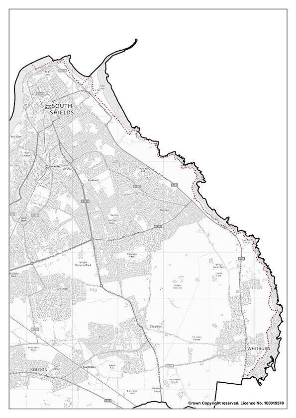
Development which involves land identified in the Coastal Change Management Area they must be in accordance with the updated Shoreline Management Plan and demonstrate that the development will be safe over its planned lifetime, provide wider sustainability benefits, and will not have a negative impact on coastal change, compromise the character of the coast or hinder the creation and maintenance of a continuous signed and managed route around the coast.
Council responsibilities relating to coastal risk management will comply with the National Flood and Coastal Erosion Risk Management Strategy for England (May 2020). A Flood and Coastal Risk Strategy for the borough highlights the Council’s approach to coastal risk management between 2017 and 2022 and sets out the management strategy for each of the Coastal Change Management Areas.
Development proposals for coastal defence schemes should seek to support opportunities for nature-based solutions, and where possible, carbon sequestration and/ or the restoration or enhancement of coastal habitats.
Development proposals should also consider the Marine Management Organisation (MMO) ‘Seascape Character Assessment for the North East Inshore and Offshore marine plan areas’ (2018), the North East Inshore and North East Offshore Marine Plan (2021) Seascape Policy NE-SCP-1 and any other relevant policies.
Delivering a mix of homes
Delivering a mix of homes is an essential element of the Plan. Giving the borough’s existing and future residents a decent, affordable home that adequately meets their needs is critical to support healthy, safe, and sustainable communities.
New housing in South Tyneside must ensure that a range of housing types are developed and maintained to provide residents with a choice of affordable accommodation that meets their needs and aspirations in attractive, safe, and sustainable neighbourhoods.
The policies in this chapter seek to deliver the aims of strategic objective 5.
Housing Supply and Delivery
Policy SP16: Housing Supply and Delivery
The Council will work with Partners and landowners to deliver South Tyneside’s overall housing requirement of 5253 net additional dwellings (309 per year) and maintain a rolling five-year land supply. This will be achieved by:
- Allocating sites to deliver at least 3498 new homes;
- Making provision for the delivery of at least 263 new homes within the designated East Boldon Neighbourhood Forum Area;
- Making provision for the delivery of at least 71 new homes within the designated Whitburn Village Neighbourhood Forum Area;
- The development of windfall sites;
- The development of small sites;
- Encouraging conversion and change of use of properties;
- Maintaining a five year land supply;
- Assessing the rate of housing delivery and supply through the annual monitoring process, with performance being assessed against the housing trajectory;
- Introducing a range of contingency measures where the supply or delivery is projected to fall below the housing requirements.
As identified in Policy SP2, and in line with the NPPF, the Strategic Housing Market Assessment (SHMA) has identified an overall housing requirement for the Plan period (1st April 2023 to 31st March 2040) of 309 dwellings per annum. This produces an overall minimum housing requirement of 5,253 new homes. Policy SP16 seeks to ensure that the housing need for the borough is met.
Housing Supply
There are several sources of housing supply that can contribute to meeting the housing need:
Completions and Commitments
The Plan base date is April 2023 for housing completions and commitments (planning permissions).
A proportion of the new houses the borough needs are already committed and are either under construction or have planning permission but have not yet started on site.
Lapse Rate
It is possible that some of these commitments will not come forward during the Plan period for a variety of reasons such as abnormal costs (e.g. contamination) or a lack of house builder interest. Non-delivery of some of these commitments could affect the Plan’s ability to meet the identified housing need. The Plan accounts for a lapse rate of 10% for commitments on site which are not yet under construction.
Projected Demolitions/Loss
South Tyneside has previously experienced relatively high levels of demolitions because of housing stock clearance and regeneration. There are, however, no further large-scale demolitions anticipated which can be planned for. Similar to windfall sites, the nature of demolitions and net losses to housing stock can be unpredictable. However, it is appropriate to account for a nominal loss attributable to demolitions going forwards as they can unexpectedly come forward through the planning process.
As plans for demolitions within the next two years are largely known through discussions with the Council’s Housing Strategy team, it is considered appropriate to account for unknown demolitions from year 3 onwards.
As there are no plans to carry out any further major clearance, for the remainder of the plan period, an allowance of 11 demolitions per year from year 3 are included, this being the historic average (when excluding the large-scale demolitions as part of council renewal programmes).
Windfalls
Over the past five years, there have been an average of 113 windfall dwellings delivered each year. However, given the progression of the Local Plan and the thoroughness of the SHLAA assessment, it would be unreasonable to assume that these levels of windfall delivery will continue. The SHLAA accounts for a windfall rate of 37 dwellings per year from year 6 onwards.
Brownfield Register
The Brownfield register identifies sites which are less than 5 dwellings. These are expected to be delivered during the Plan period.
Residual Housing Requirement
Taking the sources of supply set out above into account, Table 2 sets out the calculation used to determine how many houses the Council must plan for and allocate specific housing sites across the borough. This equates to a residual housing requirement target of 3443 (Table 2).
| A | Local Plan minimum housing requirement 2023 to 2040 | 5253 |
| B | Commitments (at November 2023) | 1475 |
| C | Completions (net) (April 2023 – November 2023)* | 122 |
| D | 10% lapse rate for commitments on sites not yet started | 95 |
| E | Projected demolitions / losses | 165 |
| F | Windfalls | 444 |
| G | Brownfield Register (small sites) | 30 |
| H | Residual housing requirement = A – B - C + D + E - F – G | 3443 |
* Including sites with a resolution to grant
Housing Allocations Supply
The Plan needs to allocate sites to accommodate at least 3443 new homes during the plan period. Chapter 5 identifies Housing Allocations that would accommodate 3498 new dwelling during the period.
Housing Delivery
The Council must maintain a sufficient supply of housing land over the Plan period to ensure the delivery of the overall housing requirement as outlined in Policy SP16 and maintain a rolling five-year supply of deliverable housing sites, including appropriate buffers.
It is anticipated that housing sites will be delivered in accordance with the housing trajectory shown in Figure 2. Housing trajectories are a planning tool designed to illustrate the expected rate of housing delivery across the Plan period. To prepare the housing trajectory, the Council has estimated the projected build out rates for all existing housing commitments and allocated sites. It is important to emphasise that the housing trajectories are not intended to produce perfect forecasts of the future but do provide as good an understanding as possible of the prospects for delivery.
If it becomes apparent that a five- year deliverable supply cannot be evidenced or that housing delivery is falling below the thresholds prescribed by the Housing Delivery Test over a rolling three year period, the Council will implement remedial action(s) to address any shortfalls. Depending upon the scale and nature of either under supply or under delivery, actions may include:
- Formally implementing those measures as required by the Housing Delivery Test
- Drawing upon more up to date supply information from the SHLAA, Brownfield Register and Employment Land Review to identify additional housing sites that are consistent with the Plan’s policies
- A partial and early review of the Plan to release additional land for new homes. This may include further consideration of releasing additional land from the Green Belt, should exceptional circumstances be met.
Figure 2 Housing Trajectory
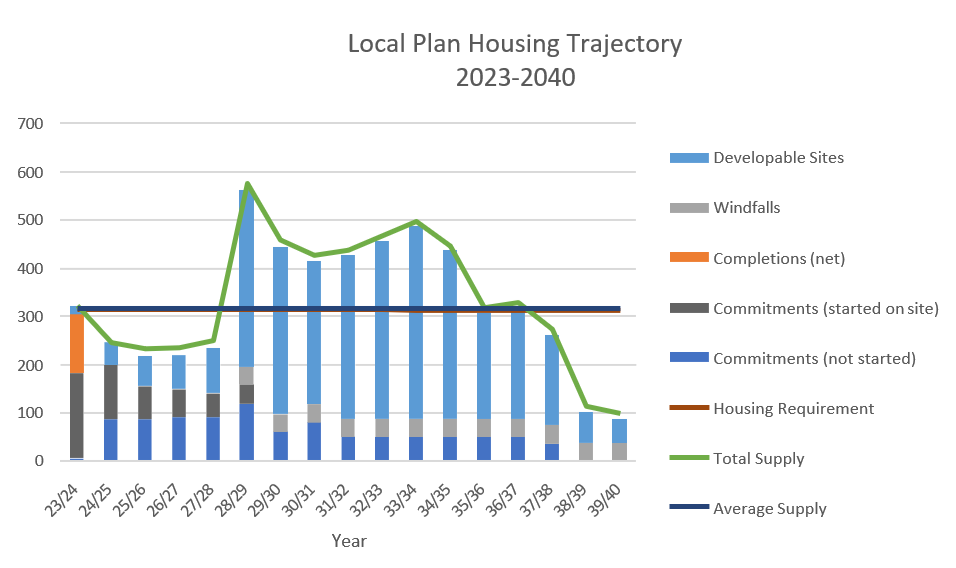
Neighbourhood Plans Housing Requirement
The NPPF states that within the overall requirement, strategic policies should also set out a housing requirement for designated neighbourhood areas which reflects the overall strategy for the pattern and scale of development and any relevant allocations. The NPPF notes that, where it is not possible to provide a requirement figure for a neighbourhood area, an indicative figure can be provided if requested by the neighbourhood planning body.
The Plan has identified an indicative figure for the neighbourhood areas based on the latest evidence of local housing need and the Plan’s spatial strategy and allocations. This neighbourhood housing requirement is a minimum and therefore Neighbourhood Plans can include additional allocations.
Windfall Sites and Backland sites
Policy 13: Windfall and Backland sites
- Residential development on sites that have not been allocated
in the Plan will be considered positively where:
- The site is previously developed or is a small infill site within the main urban area or would make a positive contribution to the identified housing needs of the borough;
- The site has access to sustainable modes of transport;
- Development would make the best and most efficient use of available land;
- It can be demonstrated that there will be sufficient infrastructure capacity, either existing or proposed, to support the level of development; and
- Development would make a positive contribution towards creating sustainable, healthy, safe and diverse communities that contribute positively to the character of the area.
- The development of residential new build within the curtilage of an existing dwelling, known as Backland development, shall:
- Have vehicular access which does not infringe on the amenity of adjacent dwellings; and
- Ensure it is acceptable in terms of the amenity of adjoining dwellings; and
- Be of a form and scale that respects the local character of the area having regard to density, size and massing of existing buildings; and
- For both the existing and proposed dwellings, provide adequate privacy, outlook, and garden space for recreational needs; and
- Ensure the setting and character of the existing dwelling is not eroded.
Whilst it is the role of the Local Plan to provide for, and specifically allocate, sites to meet the overall housing needs, proposals for new sites which have not previously been identified in the Plan will continue to come forward for consideration throughout the Plan period. Residential proposals which come forward on sites outside of those allocated in the Local Plan are known as housing ‘windfalls’.
During the Plan period land may come available to contribute towards the borough’s housing need. Policy 13 ensures that windfall and backland sites are designed and planned appropriately.
The spacious nature and low density of some of South Tyneside’s suburbs has led to development pressure for the intensification of existing housing areas through development of backland plots. This can have a significant impact on local distinctiveness and heritage significance by eroding the unique character that makes these places special, particularly if the principles of good design are not considered. It is essential therefore, if development takes place on backland sites, that it is appropriate in all respects and that it makes a positive contribution to the environment and community to ensure the local distinctiveness and character of these areas is maintained.
In particular, the traditionally designed bespoke houses set centrally within large private garden plots in Cleadon Plantation combine to provide a wooded garden suburb character to the area that is unique to the borough. In the interests of preserving the distinctive character of the Cleadon Plantation, the Council will resist development proposals for infill housing unless a development proposal complies with all three of the following:
- The site fronts directly onto a public highway
- The new and remaining plot each comprise an area of not less than 0.1 hectare, with a frontage to the highway of not less than 15 metres
- In other respects, the proposed development will not adversely affect adjacent properties in terms of privacy, daylight, sunlight, or other residential amenity considerations.
Housing Density
Policy 14: Housing Density
Proposals for residential development will be permitted provided that the development optimises the density of the site. In determining an appropriate density, development will be expected to make the most efficient use of land by taking into account the location of the development and the character of the area.
Developments should make effective use of land and resources by achieving higher densities in locations with good access to public transport and facilities. Lower densities may be more appropriate in response to the existing character of a site, in smaller settlements or to provide a range and choice of housing. In determining appropriate densities, the following will be taken into consideration:
- The mix and type of housing proposed;
- The character of the surrounding area and the wider landscape setting;
- The nature, setting and scale of the proposals including site constraints;
- Local market conditions and viability; and
- Availability and capacity of local services, facilities and infrastructure.
The South Tyneside Density Study (2023) sets out recommendations for achievable housing densities across the borough. In accordance with the following distances around the borough’s defined town, district and local centres or Metro stations, the following densities should be applied:
- Average 60 Dwellings per Hectare on sites within 400m in the Jarrow and Inner South Shields Character Areas identified on Map 20
- Within the rest of the borough:
- Average 55 dwellings on sites within 400m
- Average 45 dwellings per hectare on sites between 400-800m
- Average 35 dwellings per hectare on sites beyond 800m.
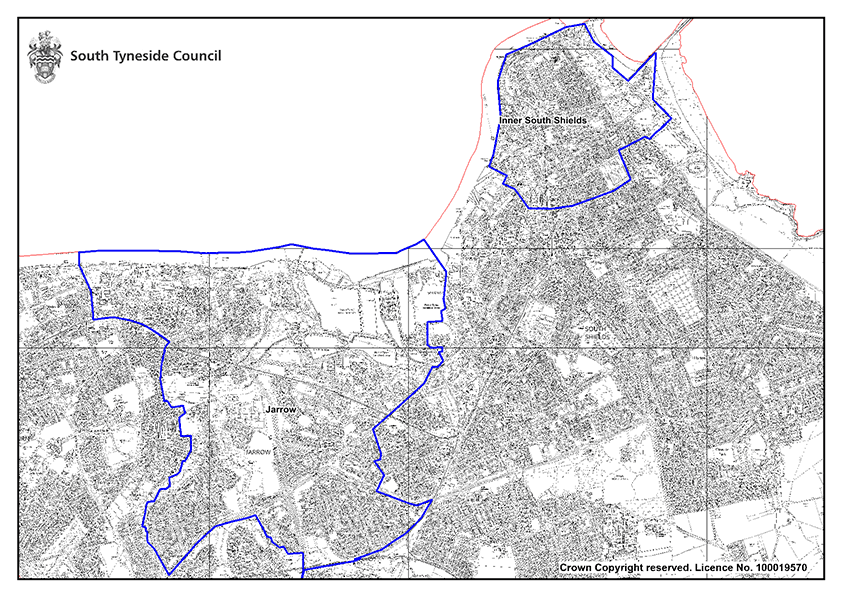
Where a site is well connected and has good access to services, sites should be designed to a higher density. Development that is design-led can achieve high densities whilst creating vibrant and sustainable places.
Significantly higher densities should be achieved in the Inner South Shields and Jarrow areas, given their character and high levels of accessibility. Proposed improvements to the accessibility of a site will be considered in implementing this policy where there is a high certainty of their delivery.
Existing Homes
Policy 15: Existing Homes
The Council, working with Registered Providers, private landlords and other key Partners shall:
- Improve the condition of existing homes by enhancing energy efficiency and reducing carbon emissions in existing buildings
- Deliver public realm improvements and enhance the attractiveness of existing residential areas
- Address problems with anti-social behaviour and promote crime reduction
- Facilitate improvements to properties that have traditionally suffered from poor management and under-investment
- Promote, develop, and implement effective initiatives which improve the condition and living standards of the existing housing stock across all tenures throughout the borough, including selective demolition where appropriate
- Bring long term empty and other appropriate buildings back into use as homes
- Encourage development through renewal / regeneration. Where this would lead to a net loss of residential housing stock, applicants must demonstrate that:
- The dwelling(s) no longer provides accommodation of a suitable sustainable standard
- It is financially unviable to improve or adapt the existing dwelling(s)
- The locality and character of the surroundings are no longer appropriate for residential use
- The proposed replacement uses make a positive contribution to the locality
It is necessary to make sure the existing housing stock is decent, sustainable, and meets the needs of our existing and future residents.
The social housing sector has received significant investment through South Tyneside Homes and other registered providers which has supported improvements to the overall condition of the existing stock to meet the Decent Homes Standard. Private housing stock, which includes owned and privately rented, provides 77% of all the homes in South Tyneside. This means that maintaining the condition of that stock becomes increasingly important, so the borough’s residents continue to have access to high quality homes in attractive areas. This will help sustain neighbourhoods and encourage sustainable growth.
In South Tyneside there are pockets of concentrations of private landlords. Typically, the higher densities of private landlords are found in the areas of highest deprivation. These are often poorly managed and maintained and they attract a transient population. This can have major implications on the attractiveness of residential areas and therefore lead to increased perceptions of crime and anti-social behaviour. The Council intends to introduce a Selective Licensing scheme in parts of the borough that have problems with the private rented sector.
In 2022, approximately 3% of the borough’s total housing stock was classed as vacant which is the same vacancy rate as for England. Vacant properties are often empty due to decanting prior to Decent Homes or similar works being undertaken, or they are being held ahead of regeneration schemes.
As part of the dwellings that are classed as vacant there are also homes that are long term vacant (empty for more than six months). In South Tyneside the percentage of dwellings that are classed as long term vacant equates to some 1.3% of our total housing stock. Any vacant property can have a negative effect on communities by becoming a potential focal point for illegal activities and anti-social behaviour. As such the Council introduced an Enforced Sale Policy in 2019 which uses powers given to the local authorities under Part III Law of Property Act 1925 and Local Land Charges Act 1975. This policy allows for the purchase of privately owned premises or land where the current owner is unwilling or unable to deal with the property / site. The main aim of the scheme is to provide a mechanism for bringing long term empty and problematic properties back into use.
The Council and its Partners continue to work to improve the quality of existing residential neighbourhoods through targeted regeneration and renewal schemes. The quality of residential neighbourhoods and the housing stock within them are important factors affecting quality of life and have implications for education, health, and other priority services.
Houses in Multiple Occupation
Policy 16: Houses in Multiple Occupation
- Where planning permission is required, proposals for Houses in Multiple Occupation (HMOs) will be permitted where:
- The building is suitable for the number of proposed units and the accommodation provides a good standard of living space and amenity for the occupiers
- The proposal would not result in an over-concentration of HMOs within any one area of the borough, or lead to HMOs becoming the dominant dwelling type, or adversely impact on the functionality and characteristics of a local area.
- The proposal does not result in any residential property (C3) being directly ‘sandwiched’ between two HMO’s on both sides.
- The proposal would not have a detrimental impact on the amenities of surrounding properties by causing excessive noise and disturbance
- The proposal would provide adequate provision for parking, servicing, refuse and recycling
- Where an application for a new House in Multiple Occupation falls within the Lawe Top Article 4 Direction area, permission will only be granted where the number of HMO dwellings does not exceed 10% of the total number of properties, within 100 metres from the application site.
Houses of Multiple Occupation (HMOs) are defined as having a shared toilet, bathroom or kitchen that is the main residence of three or more occupiers who form a household. It is possible for single dwelling units to be converted into an HMO of between 3 and 6 household units without planning permission.
The Houses of Multiple Occupancy Topic Paper (2023) sets out the distribution and local impacts of HMO’s in South Tyneside.
HMOs can and do help to meet the housing need within the borough by providing diverse and affordable properties. However, they can tend to be grouped together as certain property types are more suitable for conversion than others.
This can lead to clustering and HMOs becoming the dominant type of accommodation within an area.
In South Tyneside, HMOs are typically clustered around areas of old, larger housing that can often be easily converted into multiple units. Government has recognised that high clusters of HMOs in an area can lead to:
- Increased anti-social behaviour, noise, nuisance, and crime
- Imbalanced and unsustainable communities
- Negative impacts on the physical environment
- Parking pressures
- Pressure on community facilities.
Therefore, when assessing applications for HMOs, consideration will be given to the impact on the amenity of the area, the impact of additional traffic generation and the existence of other HMOs.
When considering whether there is an over concentration of HMO properties within the locality, the Council will consider each proposal on its individual merits, taking into account the numbers and concentration of existing HMOs and the character of the area.
To reduce the immediate impact of HMO’s on residential properties and to assist in reducing over- concentration in localised area, permission for new HMO will not be approved where it would lead to a residential property being directly ‘sandwiched’ between two HMO’s.
An article 4 direction is a direction under article 4 of the General Permitted Development Order which enables the local planning authority to withdraw specified permitted development rights across a defined area. In South Shields Town Centre (Lawe Top Article 4 Direction Area) we require the owner of a residential properties to apply for planning permission, should they want to convert a residential property into a ‘small HMO’. Where an application for a new HMO falls within the Lawe Top Article 4 Area (Inset Map 21), permission will only be granted where the number of HMO’s, within 100m from the application site is below 10% of the total number of properties.
In assessing planning applications for new HMOs, a 100-metre circle radius will be drawn from the address point (middle of the property). The percentage calculation will count residential properties whose address point falls within the circle. Dwelling houses and HMOs that are located within blocks of flats or subdivided properties are counted as one property. Residential institutions, care homes, hostels and purpose- built student accommodation and other specialist housing are also counted as one property per block. This will ensure that calculations of HMO concentration are not skewed.
The application of this criteria will contribute to the management of over-concentration of HMOs in this area.

Specialist Housing – Extra Care & Supported Housing
Policy 17: Specialist Housing – Extra Care & Supported Housing
- Specialist housing, including supported housing and extra care, will be supported where applicants can demonstrate the development:
- Will integrate into the local residential community
- Is in a location accessible by public transport or within a reasonable walking distance of community facilities such as shops, medical services, and public open space. Where this is not the case, such facilities shall be provided on site
- Accommodation should seek to deliver and promote independent living in new build properties as well as adaptations to existing homes.
As across the UK, South Tyneside has an aging population and in 2016 it was estimated that by 2041 there will be an additional 12,700 residents in the 70 and over age bracket. As a result, there are increasing demands for specialist housing that helps to support elderly people in the community who often have specific housing needs. Providing the right type of housing will help people to maintain independent living or support assisted living where appropriate.
Alongside the increasing aging population comes an increase in the amount of people with physical or learning disabilities and other vulnerabilities that require additional support.
The South Tyneside Adult Social Care Accommodation Strategy (2018) identifies a need for additional extra care accommodation to help reduce numbers of people living in residential care facilities. The borough currently has a high number of people in residential care whose needs could be met in more cost-effective accommodation such as extra care or supported living accommodation.
To deliver the community support services in an appropriate environment there will need to be an increase in the provision of extra care and supported living accommodation at the same time as a reduction and redesign of the residential and nursing care offer. At the time of publication, South Tyneside’s residential and nursing home market had approximately 20% vacancies whilst most models are built on a 5% vacancy rate.
Given the high level of need for specialist accommodation, the Local Plan seeks to ensure that new development contributes to a range of attractive housing options for older people and those with specific needs, including self-contained specialist housing and residential institutions.
Applications for accommodation for looked after children should also be considered under Policy 17 and supported where appropriate.
Proposals must demonstrate that the specialist housing will be an attractive option designed to contribute and improve the intended residents’ quality of life. Where specialist accommodation is provided, it must enable residents to live independently, as far as possible, by ensuring it is located close to facilities and services or that they are accessible by public transport. Proposals for specialist housing should also demonstrate how the development contributes to an inclusive community and avoids creating neighbourhoods with exclusively specialist housing provision.
Affordable Housing
Policy 18: Affordable Housing
- To meet the borough-wide need for affordable housing, developments of new housing of 10 or more dwellings, or development on a site of 0.5ha or more will be required to deliver affordable housing, where appropriate and viable.
- Affordable housing provision shall be delivered on site or, where robustly justified, an equivalent financial contribution in lieu of onsite provision.
- Development of new housing of 10 units or more, or on a site of 0.5ha or more, shall deliver a minimum:
- 10% affordable homes in South Shields and Jarrow
- 15% affordable homes in Hebburn
- 20% affordable homes in West Boldon and Boldon Colliery
- 25% affordable homes in East Boldon and Whitburn Village
- 30% affordable homes in Cleadon
- The exact type and tenure of affordable housing to be provided on site should be identified through discussions with the Council, the latest Government guidance, and the following requirements:
- On sites with an overall affordable housing requirement of 25% or more, 25% of all affordable housing to be delivered as First Homes. The remaining affordable housing requirement should be delivered according to a tenure split of 75% affordable rent and 25% affordable home ownership;
- On sites with an overall affordable housing requirement of 20% or less, 25% of all affordable housing to be delivered as First Homes, after which priority will be for delivery of affordable rent, subject to satisfying the national planning policy requirement for at least 10% of the total number of homes to be available for affordable home ownership.
- Where an applicant considers that the provision of affordable housing in accordance with the requirements of this policy would make the scheme unviable, they must submit a fully detailed viability assessment to demonstrate that this is the case. The submission must show the maximum level of affordable housing that could be delivered on the site. The applicant shall be expected to deliver the maximum level of affordable housing achievable.
- Affordable housing provision and/ or in-lieu financial contributions will be secured by way of a Section 106 planning obligation. For affordable housing for rent, discount market sale housing, or where public grant funding is provided towards other affordable routes to home ownership, a planning obligation will be required to ensure that the onsite provision remains affordable in perpetuity.
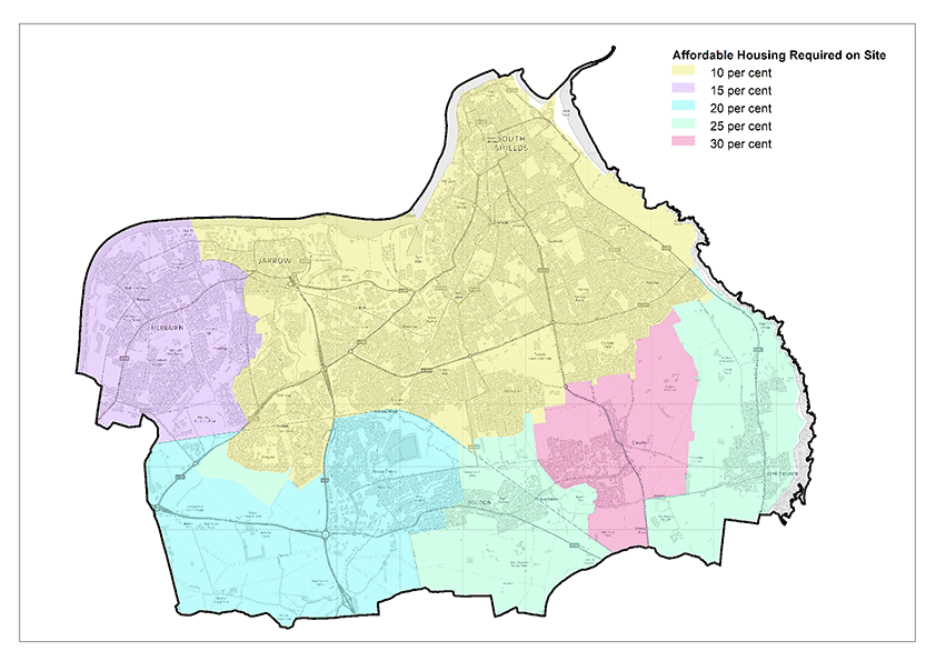
The NPPF defines affordable housing as ‘housing for sale or rent, for those whose needs are not met by the market’. This also includes housing provision via a subsidised route to home ownership and/or would be essential for local workers. Securing an appropriate level of affordable housing will support the Council in meeting the identified needs and allow access to high quality affordable housing for those people who would otherwise be unable to afford other housing. The role of affordable housing is therefore to bridge this gap of inequality and enable people to be able to afford a lower rental level or purchase price. This then helps reduce housing need in the borough that might present itself as homelessness or overcrowding.
The NPPF also goes on to outline that where major development involving the provision of housing is proposed, planning policies and decisions should expect at least 10% of the homes to be available for affordable home ownership, unless this would exceed the level of affordable housing required in the area or significantly prejudice the ability to meet the identified affordable housing needs of specific groups. In accordance with the NPPF, exemptions to this requirement would be made if a development provides solely for Build to Rent homes, specialist accommodation for a group of people with specific needs, self or custom build, or exclusively for affordable housing.
Affordable housing is informed by need and is identified in the SHMA (2023) which found that there was a need for an additional 361 affordable units per year, including social/affordable units or intermediate tenure. The need for affordable homes is assessed using Planning Practice Guidance (PPG). Occasionally the number is higher than the overall housing need which means there is a considerable need for affordable housing. However, PPG goes on to say that the total affordable housing need can then be considered in the context of its likely delivery as a proportion of mixed market and affordable housing developments, taking into account the probable percentage of affordable housing to be delivered by eligible market housing led developments.
An increase in the total housing requirement included in the Plan may need to be considered where it could help deliver the required number of affordable homes. However, the SHMA does not recommend an uplift to the total housing requirement as it recognises the Council is taking positive steps towards increasing the affordable housing offer in the borough, such as delivering affordable homes through South Tyneside Homes.
In South Tyneside, affordable housing is delivered by the Council, Registered Providers, or private developers. Often affordable housing development is subsidised from the Department of Levelling Up, Housing and Communities through Homes England, whose funding is often key to enabling development via grant funding. Given that the identified affordable housing need in the borough will be difficult to achieve, the Council will continue to work with these key Partners to maximise opportunities for increased numbers of affordable housing units in addition to homes negotiated through planning obligations.
In line with NPPF, pursuing sustainable development requires careful attention to viability. The Council has undertaken an assessment of viability through the Local Plan Viability Testing. This has informed realistic targets for the delivery of affordable housing which do not threaten viability and the delivery of housing, and which include an assessment of the impacts of other policy requirements included within the Plan.
The typology testing results for the ‘Local Plan Viability Testing’ report (2023) shows that different locations in the borough can sustain different levels of affordable housing. The report concludes that the following levels of affordable housing provision are reasonable:
- Cleadon– 30%
- East Boldon and Whitburn Village – 25%
- West Boldon, Boldon Colliery – 20%
- Hebburn – 15%
- South Shields, Jarrow – 10%
In accordance with the 2023 SHMA, the Council will seek a tenure split of 75% affordable rent and 25% affordable home ownership. This is subject to the NPPF requirement of 10% of all dwellings being delivered for affordable home ownership. The Planning Practice Guidance (PPG) states that to qualify as a First Home, a property must be sold at least 30% below the open market value. A higher minimum house price discount of either 40% or 50% for First Homes buyers can be applied if a need is evidenced. Proposals should have regard to the Discounted Market Sales Policy Statement (2023) and the First Homes Interim Policy Statement (2022) and any successor documents.
To ensure sufficient quality accommodation is available to meet current and future needs, a supply of good quality, affordable housing is required. Affordable housing should be provided onsite where practicable. Developments should be ‘tenure neutral’ so that affordable housing is not distinguishable from market housing by layout, design, or materials.
Housing Mix
Policy 19: Housing Mix
- Housing development shall deliver an appropriate mix of housing types, sizes, and tenures to meet identified needs and to create and maintain mixed and balanced sustainable neighbourhoods by:
- Contributing to meeting affordable housing need, market housing demand and specialist housing as identified through the SHMA or its successor documents;
- Providing an appropriate mix of house types and sizes which enhance local housing options and are acceptable for the site and its location
- Development, where appropriate and justified, should also seek to:
- increase the supply of detached homes in the borough
- increase the choice of suitable accommodation for the elderly population and those with special housing needs including bungalows and extra care housing
- Encourage the inclusion of self- build and custom housebuilding plots as part of larger housing developments, where it is viable and where there is an identified need
- Ensure new homes meet the needs of our aging population and are accessible to all.
To ensure that a choice of homes is available that will address the need for homes of different types, developments should include an appropriate mix of dwelling types and sizes to address needs measured over the long term, considering the nature of the development and character of the location. The Council also recognises the need for the market to provide a choice in terms of type and mix of housing.
It is important that new homes provide a mix of good quality homes, designs and tenures which will contribute towards catering for people choosing to stay or move into South Tyneside whilst delivering sustainable neighbourhoods.
While most of the development within the Plan period will be carried out by private developers, it is still important that an appropriate mix of housing is developed to meet the housing need. The SHMA provides information on the housing need in the borough as well as information on the type and size.
Custom and Self Build
The Housing and Planning Act 2016 supports existing legislation for self- build and custom housebuilding by requiring Local Authorities to ensure sufficient serviced plots, with permission, are available to meet demand in their area.
The Council has a Self and Custom Build Register, enabling people who are interested in finding suitable building plots in South Tyneside to register an interest and will support individuals who wish to build houses for their own occupation. The Council will use the information contained within the register to inform decisions regarding the type and mix of housing on individual sites.
Technical Design Standards for New Homes
Policy 20: Technical Design Standards for New Homes
- To meet the needs of older people and people with disabilities, a minimum of 5% of new build housing in developments of 50 homes or more shall be built to Building Regulations Requirement M4(3) (wheelchair user dwellings).
- All residential dwellings shall be designed to be built to meet Building Regulations Requirement M4(2): (Accessible and adaptable dwellings) except where it can be demonstrated that this is impractical or unviable due to site specific constraints.
Meeting the needs of an ageing population and those living with a disability presents challenges for housing provision. Providing more accessible homes will ensure that the borough’s housing stock is more easily adaptable and will help people to maintain their independence for longer. Housing developments should provide flexible, socially inclusive and adaptable accommodation to help meet the changing needs of residents over time.
South Tyneside’s older population is increasing and as people age so does the prevalence of illness and disability. According to Living Better Lives 2022-2026, the Council’s Adult Social Care Strategy, 12% of our residents have a long-term health problem or disability. The Strategy seeks to support residents to live independently as much as possible, appropriate housing is a key element of this.
In March 2015, Government introduced optional accessibility standards for new dwellings to provide a mechanism for improving accessibility of housing for those with additional needs. The aim of the national set of standards is to enhance residential quality and reduce the administrative burden on new housing developments by simplifying and rationalising the wide variety of standards that local authorities across England apply to new homes.
Given the ageing population in the borough and the identified levels of disability amongst the population, the SHMA (2023) recommends that a policy requiring new homes built to accessibility standards is warranted. Based on available evidence, the SHMA suggested that a minimum of 5% of new homes should be compliant with Building Regulations M4(3) and that all new homes should be M4(2) compliant.
Based on this evidence, the Council will require 5% of housing developments over 50 dwellings to be M4(3) compliant. Appropriate house types considered to meet this requirement includes level access flats and level access bungalows.
The policy also requires all new dwellings to be M4(2) compliant, however, the Council recognises the need to balance this requirement with achieving acceptable densities on site and making the best and most efficient use of land. Where it can be evidenced by the applicant that applying the M4(2) standard to all dwellings would make the proposal viable or would unacceptably impact the efficient use of land, then proposals for an alternative proportion of M4(2) compliant dwellings on the site will be considered.
To allow for an appropriate transitional period, the standards relating to accessible and adaptable dwellings will only be applied to outline or full applications submitted 6 months after the date of the Plan’s adoption. It will not be applied retrospectively to those applications for reserved matters where the outline permission was determined or is subject to a resolution to grant permission (including subject to planning obligations).
Gypsies, Travellers and Travelling Showpeople
Policy 21: Gypsies, Travellers and Travelling Showpeople
- As defined on the Policies Map, the existing authorised Gypsy and Traveller site at West Pastures shall be maintained unless it is no longer required to meet an identified need.
- Where proposals for Gypsy and Traveller sites or Travelling Showperson yards are brought forward on non-allocated land, proposals will be supported where they can demonstrate:
- The proposal is adequately justified through robust evidence of need for additional Gypsy and Traveller pitches; and
- The proposal would not be located within any known flood risk areas; and
- The proposed site is accessible to education, health, and other community facilities; and
- The proposed site is not located within Green Belt except where it can be demonstrated that very special circumstances outweigh harm to the Green Belt; and
- The proposal can be sympathetically assimilated into the surroundings and includes appropriate landscaping to protect local amenity and the environment; and
- The proposed site will promote peaceful and integrated co- existence between the site and the local community; and
- The proposed site will avoid undue pressure on local infrastructure and services; and
- the proposed site is capable of accommodating on-site facilities that meet best practice for modern Traveller site requirements, including play areas, storage and provision for recycling and waste management; and
- The proposal enables mixed business and residential accommodation, providing for the live-work lifestyle of Travellers where appropriate; and
- The proposal accords with all other relevant policies within this Local Plan.
Planning for the accommodation needs of Gypsies, Travellers and Travelling Showpeople is a necessary element in meeting the housing needs of all residents of South Tyneside. However, the nature of this accommodation differs from a standard bricks and mortar housing development.
For the purposes of this planning policy, ‘travelling community’ means ‘Gypsies and Travellers’ and ‘Travelling Showpeople’ as defined in Planning Policy for Traveller Sites (PPTS) (2012). This sets out the government’s policies and requirements in provision of sites for the travelling community and must be taken into consideration in preparing local plans and taking planning decisions.
There is one permanent site in South Tyneside for the travelling community at West Pastures, West Boldon. This site is fully authorised and was granted planning permission in December 2013 for 11 Gypsy and Traveller pitches, providing a settled base for residents that allows them to access local health care and education provision. All 11 pitches were occupied when last surveyed in 2018.
There is a site for Travelling Showpeople at South Promenade, Sea Road, South Shields. Through research undertaken in April 2014 it was suggested that this community should not necessarily be classed as travelling as the fairground is a permanent feature.
All local authorities are required to formulate their own evidence base for the accommodation needs of the travelling community and, if necessary, to provide their own targets relating to pitches required. The South Tyneside Gypsy, Traveller and Travelling Showpeople Accommodation Assessment (2023) concluded that there is a need for a permanent site within the borough for 11 pitches required to 2040.
There is, however, no required need for transit/stopover sites due to the lack of evidence of unauthorised encampments.
To help meet the accommodation needs of the borough’s gypsy and traveller community, the Council will continue to ask landowners to put forward any available land they think is suitable for this use.
Any new settlement would need to be appropriately located to meet the needs of potential residents of the site, respect the interests of the settled community and sustain the local environment. A new community may require associated infrastructure including schools, utilities, and improvements to the highway network to enable suitable access. Proposals will not be permitted unless the existing infrastructure can accommodate the needs, or the proposed site intends to deliver the necessary improvements as part of its development.
The nomadic nature of the travelling community means that this is a cross-boundary issue, particularly with Sunderland to the South. The Council has been engaging with other LPAs in the North East to gather evidence to understand the needs for Gypsies and Travellers in the wider area and will continue to do so as part of the duty-to-cooperate. South Tyneside will continue to monitor the wider housing needs of the travelling community to make sure they are being met at a local and sub- regional level.
Building a strong, competitive economy
The NPPF states that planning policies should set out a clear vision and strategy which positively and proactively encourages sustainable economic growth, having regard to local policies for economic development and regeneration.
The policies in this chapter seek to deliver on the aims of Strategic Objectives 6 and 7 by:
- Providing a portfolio of employment sites to support economic growth;
- Support opportunities for business growth, job creation and reducing inequalities
- Support the visitor economy in South Tyneside
Strategic Economic Development
Policy SP17: Strategic Economic Development
A comprehensive approach to building a stronger and more resilient local economy will be achieved by:
- Maintaining a portfolio of 278.35 ha of land for economic development including 141.3 ha of land for specialist port-related development
- Supporting the Port of Tyne as a key economic asset for the borough and the region
- Strengthening the Advanced Manufacturing and Engineering sector and supporting opportunities that arise from IAMP
- Supporting growth in the Digital and Technology sector
- Investing in skills, education, and training opportunities which enhance the skills of the workforce and are aligned to key growth areas, including Advanced Manufacturing and Engineering, Health and Social Care, Digital and Technology
- Attracting new businesses and encouraging existing businesses to grow through:
- Supporting the provision of appropriate accommodation for new and growing business service companies and digital and tech companies
- Seeking to ensure businesses and entrepreneurs are given the best possible chance to access funding opportunities for businesses to start-up and to scale-up
- Continuing to support the visitor economy.
The borough has a proud industrial heritage and a continuing strength in the advanced manufacturing and engineering sector on which the Council is determined to build on. This is exemplified by the International Advanced Manufacturing Park, home to much of Nissan’s automotive supply chain and soon to house the UK’s largest, at scale, battery plant.
The borough’s logistics offer benefits from an excellent strategic highway network with the A194 providing the main route into South Shields from the A19 and the A185 providing access to the Port of Tyne and the Tyne Tunnels.
Traditionally, employment has been concentrated in the north of the borough along the River Tyne. Part of Holborn Riverside in South Shields benefits from Enterprise Zone status which was awarded to support the growth of the marine, offshore energy and services sector in the region.
In the south-west of the borough, Monkton and Boldon Business Parks offer modern, purpose-built flexible workspace in an area with excellent road links and high market demand.
The Council recognises the challenges and opportunities presented by the digital, health and social care and green economies and is determined to improve the borough’s offer, particularly given the innovative mine energy and district heating schemes underway and the skills shortages in health and social care. Achieving these aspirations means that a robust supply of employment land is needed, and this Local Plan ensures that that will be the case.
The Council will also further strengthen the visitor economy offer which benefits from the attractiveness of the coast, the quality of South Shields as a resort, and as a popular visitor attraction for venues that include the National Centre for the Written Word, the Customs House, Arbeia Roman Fort, and Jarrow Monastery.
Port of Tyne
The Port of Tyne is a key economic asset for the borough and a key business partner in the logistic sector for regional, national, and international connections offering a range of services including bulk and project cargoes, automotive industry cargoes and an estates role. The business and property market stakeholders for the ELR recognised it as a key economic asset for the borough. As well as making a significant contribution to the Transportation and Storage sector, the importance of the Port for the future developments around the International Advanced Manufacturing Park is also critical. The Port of Tyne’s car terminal benefits from secure storage facilities and a rail distribution terminal. It is recognised as a major European vehicle handler and will continue to be an important asset to many operators who locate to IAMP. The Council will continue to work in Partnership with the Port of Tyne to grow its international role and to increase the volume of imported and exported goods and associated logistics.
Advanced Manufacturing and Engineering
The ELR recognises that the advanced manufacturing and automotive sectors play an important role in the borough. In this context, it should be seen as part of a wider regional offer with future drivers likely to be cross- boundary such as IAMP. There are 30,000 jobs regionally in the advanced automotive sector and there is the potential to increase this significantly.
Digital and Technology Sector
In South Tyneside there are fewer businesses in the Information and Communications sector than is seen nationally. Whilst the digital offer is highly-fragmented with a lack of a well-defined hub, there is potential for supporting digital and technology businesses and ensuring residents have the skills needed for this growing sector to take advantage of the growth opportunities over the coming years.
Visitor Economy
Direct visitor expenditure in South Tyneside in 2022 was £272 million, up by 52% on 2021.The South Tyneside Destination Management Plan (2017 to 2022) recognises that, although South Tyneside has a well- established and good quality visitor offer, there is the potential to attract more people to the area.
The visitor economy plays a significant role in the local economy, with a much higher number of businesses providing accommodation and food service activities than across England as a whole. This sector, as well as arts, entertainment, and recreation, provides employment levels above the national average.
Economic Allocations
It is important to ensure that there is a portfolio of available sites across the borough which are attractive to new employers, allows the expansion of existing businesses and responds to the changing needs of businesses. It is essential that these are in areas that offer good opportunities to attract investment.
Employment Land for General Economic Development
Policy SP18: Employment Land for General Economic Development
- To ensure there is a continuous and flexible supply of employment land to meet the borough’s needs over the plan period, the following sites, as shown on the Policies Map, are allocated for general economic development:
- The Council will consider the use of planning conditions for applications which are for offices, research and development or light industrial uses (Use Class E[g]) to ensure that they remain in that use in perpetuity.
| Site Ref | Site Name | Use Class | Total Area (Gross) (ha) | Available Area (Net) (ha) |
|---|---|---|---|---|
| SOUTH SHIELDS | ||||
| ED.1 | Bede Industrial Estate | E(g)/B2/B8 | 37.75 | 1.84 |
| ED.2 | Simonside Industrial Estate | E(g)/B2/B8 | 32.5 | 1.36 |
| ED.3 | Middlefields Industrial Estate | E(g)/B2/B8 | 24.8 | 0.61 |
| ED.4 | Western Approach Industrial Estate | E(g)/B2/B8 | 7.2 | 0 |
| JARROW | ||||
| ED.5 | Land bounded by Priory Road and Church Bank | B2/B8 | 6.8 | 0 |
| ED.6 | Land bounded by Chaytor Street, Ellison Place, the Metro Line and Berkley Way | B2/B8 | 45.9 | 12.15* |
| HEBBURN | ||||
| ED.7 | Industrial Estate off Wagonway Road | E(g)/B2/B8 | 37.45 | 0 |
| MONKTON | ||||
| ED.8 | Monkton Business Park | E(g)/B2/B8 | 29.8 | 0 |
| FELLGATE | ||||
| ED.9 | Wardley Colliery | B2/B8 | 12.7 | 6.71** |
| BOLDON | ||||
| ED.10 | Boldon Business Park | E(g)/B2/B8 | 41.6 | 0.60 |
| ED.11 | Cleadon Lane Industrial Estate | E(g)/B2/B8 | 2.1 | 0 |
| Total | 278.6 | 23.27*** | ||
*The site for which the available area has been estimated is the former Dow Chemicals site
**Proposal for Wardley Colliery must refer to Policy SP14
*** Allowance of 0.69 ha has been made for the employment component of the Holborn allocation
Policy SP18 allocates general employment areas and, where relevant, available employment land within the general employment areas (As shown on Map 23). Available employment land provides potential development opportunities within the Plan period. An assessment of sites was undertaken to inform the Employment Land Review (2023) and has informed site selection. These sites provide a wide range of choice in terms of both size and location and, in addition to the International Advanced Manufacturing Park, will help to support the growth ambitions of the Northeast Local Enterprise Partnership.
Sites that are currently available are identified on the inset map below:
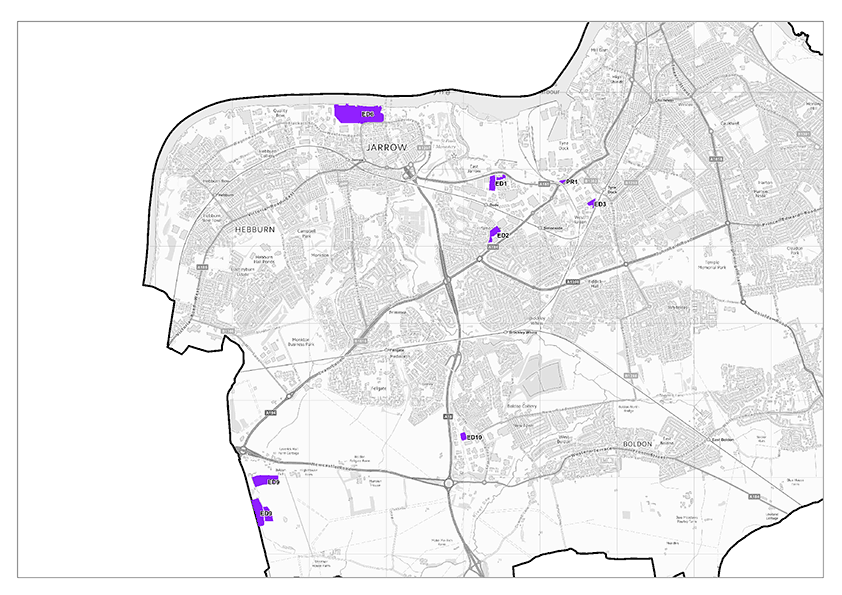
Policy SP19: Provision of Land for Port and River-Related Development
- To support its continued operation as a key strategic gateway to trade, the Port of Tyne, as shown on the Policies Map, is allocated for port-related economic development opportunities. Where planning permission is required, specialist uses such as heavy processing industries, port services, offshore technology, subsea sector and green technologies will be supported within the uses specified in the table below. Other suitable employment-related sui-generis uses that require port or direct riverside access will also be supported.
| Site Ref | Site Name | Use Class | Allocated Area (ha) | Available Area (Net) (ha) |
|---|---|---|---|---|
| PORT OF TYNE | ||||
| PR.1 | Port of Tyne | E(g)/B2/B8 | 141.3 | 25.38 |
| Total | 141.3 | 25.38 | ||
The Port of Tyne is a significant driver of economic activity within South Tyneside. The importance of the Port of Tyne is recognised in the Employment Land Review (2023) and can be seen in its being selected as the operations base for the Dogger Bank (collectively the phases of the Dogger Bank will become the world’s largest offshore wind farm). Land with access to rivers or the sea to are identified specifically for operators in the offshore and the maritime sectors, or for those requiring access to a river for import or export.
The Port of Tyne and accessible river site provide unique opportunities for specialist economic development. The Port of Tyne benefits from permitted development rights to approve port-related development on land in its ownership, Policy SP19 support the ports activities where planning permission may be required. Green technologies refer to manufacturing and storage to support offshore renewable industry and marshalling of offshore renewable infrastructure.
The North East Inshore and North East Offshore Marine Plan (2021) policy NE-EMP-1: Employment supports proposals for the increase in marine-related employment opportunities. Where relevant, proposals should consider this policy alongside the plan policies.
Map 24 Port of Tyne available sites

Protecting Employment Uses
Policy 22: Protecting Employment Uses
Development within allocated Employment Areas (Policies SP14, SP18 and SP19) for alternative uses will only be supported where the applicant has clearly demonstrated through the submission of robust evidence that:
- The site is no longer viable for employment purposes as demonstrated by an active and robust process of marketing extending to be at least 12 months
- The applicant has demonstrated that redevelopment or refurbishment of the site is not viable for continued employment uses, or continued employment use would result in unacceptable traffic or environmental problems which would be significantly alleviated by the proposed use
- The standard of amenity that would be experienced by the future occupants of the proposal would be acceptable
- The proposed use would not prejudice the operation of neighbouring properties and businesses
- The proposed use would not result in an unacceptable reduction in the supply of land and buildings required for employment uses, taking into account the range and choice of available employment land for the remainder of the Plan period and the supply of employment land in the future.
The safeguarding of the borough’s employment land and buildings for employment uses is vital to support a growing and diverse economy. It is also important to strike the right balance between this and having the flexibility to allow alternative uses where this is appropriate. Policy 22 sets out the criteria for when a site is considered to no longer have a reasonable prospect of coming into use for employment purposes. The Council will continue to monitor employment land supply in terms of take up and review the existing portfolio of employment land to ensure it remains fit for purpose.
Employment Development beyond Employment Allocations
Policy 23: Employment Development beyond Employment Allocations
Employment development outside of allocated employment sites within the Main Urban Areas will be supported where development:
- Satisfies the sequential test set out in the NPPF if the development comprises offices
- Cannot be accommodated on allocated employment sites as defined by Policies SP14, SP18 and SP19
- Would not create undue harm to the character, appearance, or amenity of the area
- Would be accessible to sustainable travel opportunities and there is appropriate vehicular access.
Whilst the established employment areas will be the most appropriate location for businesses, it is acknowledged that to maximise opportunities to grow the local economy and be responsive to changing market conditions, there may be occasions where a certain use requires a location outside of these areas. Policy 23 provides the flexibility to respond positively to applications for employment land development that constitute sustainable development and make a positive contribution to the local economy.
The Council will require applicants to provide a detailed statement justifying why development cannot be accommodated within designated employment areas. This should include evidence that the proposal would not adversely impact upon the functionality of existing employment areas.
Safeguarding land at CEMEX Jarrow Aggregates Wharf
Policy 24: Safeguarding land at CEMEX Jarrow Aggregates Wharf
- The existing minerals transport and processing infrastructure at the CEMEX Wharf in Jarrow, as shown on the Policies Map, is safeguarded to allow for the importation, processing, and distribution of marine aggregates
- Development within the safeguarded site or in its vicinity that would conflict with the use for which this site is safeguarded, or would result in unreasonable restrictions being placed upon its operation, will not be supported
- Development proposals will need to demonstrate how any impacts on the strategic road network will be mitigated.
The land bounded by Priory Road and Church Bank in Jarrow includes the CEMEX Jarrow Aggregates Wharf. Marine dredged sand and gravel is landed at this wharf, making the site strategically important for the supply of sand and gravel for use as construction aggregates to South Tyneside and the wider region. It is also a major national facility for its current operator CEMEX. The safeguarding of this site seeks to prevent sensitive or inappropriate new development either within or in the vicinity of the safeguarded site that would cause a conflict with the use of site for the importation, processing, and distribution of marine aggregates.
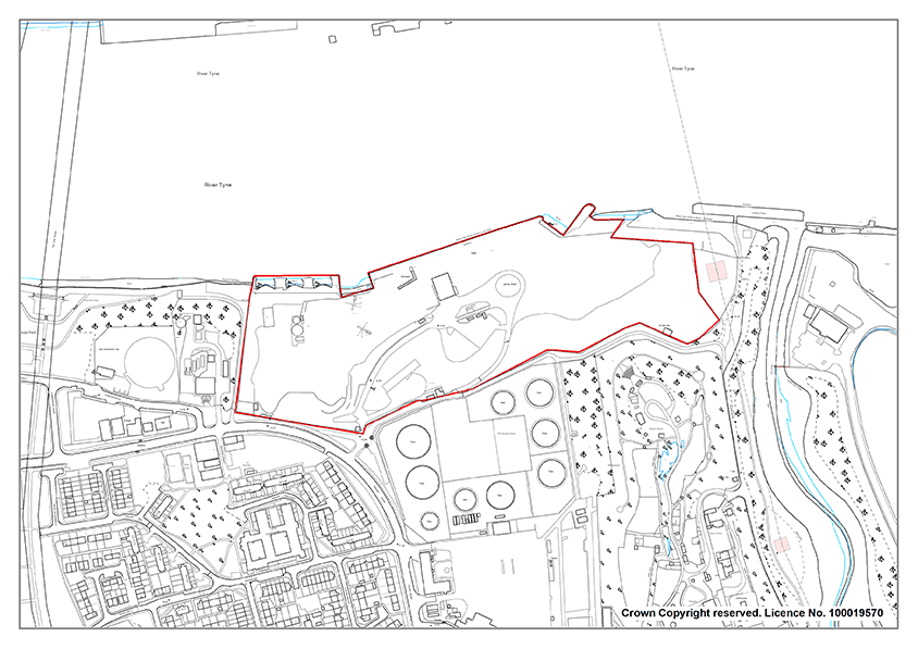
Leisure And Tourism
Policy 25: Leisure and Tourism
- South Tyneside’s diverse range of leisure and tourism attractions and facilities will be enhanced by supporting:
- The role of the town centres as the principal location for tourism, entertainment and leisure facilities
- Proposals which enhance the range and quality of visitor attractions and facilities along the Foreshore, making it a destination of choice for visitors and tourists.
- Proposals for the conservation and enhancement of Jarrow Hall and St Paul’s Monastic Site
- The expansion of existing or the provision of new tourist attraction and visitor accommodation and leisure facilities will be supported, provided that they are of a suitable scale and type for the location, do not result in unacceptable impacts, and they follow the sequential approach to location set out in Policy 27 where appropriate to the scale of the development.
- Proposals which make greater use of the River Tyne and the South Shields Foreshore Area for water-based leisure and recreational resources, will be supported, provided that they do not compromise the safety and operation of commercial river- related uses or other recreational pursuits or have an adverse impact on natural and built assets.
- Proposals for leisure and tourism development that have the potential to result in a likely significant effect on European coastal designations shall be subject to Habitat Regulations Assessment.
Tourism and the visitor economy is a key asset for South Tyneside, which continues to draw visitors and associated economic benefits to the borough. Policy 25 seeks to support, opportunities to expand our tourism offer, redeveloping visitor attractions and supporting local businesses.
Tourism and visitor accommodation and attractions and facilities can include commercial and non- commercial visitor attractions - theatres, museums, visitor centres, heritage sites and monuments, gardens and beach huts.
South Shields is the focus of the visitor economy for the borough. The town centre already supports a range of visitor attractions and leisure facilities including The Word: The National Centre for the Written Word, Customs House, South Shields Museum and Art Gallery and providing central location for the night-time economy.
The Anglo-Saxon Farm, Bede Museum and Jarrow Monastery provide a popular visitor destination in Jarrow. Hebburn Central and Jarrow Focus, both of which are leisure hubs, strengthen the roles of Hebburn and Jarrow town centres as leisure destinations that serve their local catchment areas. The policy will continue to support town centre tourism and leisure proposals, where their location is considered to be appropriate and, where applicable, they follow the sequential approach to location set out in Policy 27.
The South Shields Foreshore is the developed part of the coastal area and is the primary location for coastal leisure and tourism activities. The beaches, coastal parks and open spaces along the foreshore are popular for both residents and tourists, providing a wide range of sport, recreation, leisure, and entertainment facilities.
North East Inshore and North East Offshore Marine Plan (2021) policy NE-TR-1: Tourism and Recreation promotes and sustainable tourism and recreation activities in coastal areas. Where relevant, proposals should consider this policy alongside the plan policies.
Leisure and Tourism development within the Foreshore area should consider potential effects upon Seascape. Seascape considers landscape impacts and unique coastal considerations. Development proposals should consider the Marine Management Organisation (MMO) Seascape Character Assessment for the North East Inshore and Offshore marine plan areas (2018) and the North East Inshore and North East Offshore Marine Plan (2021) Seascape Policy NE-SCP-1.
The wider coastal area attracts a variety of water-based recreational pursuits. Whilst the Council wants to encourage leisure activities, it is important to ensure that proposals do not result in negative effects on the sensitive coastal environment or exiting commercial river- related uses.
Most of the coastal area is designated as a Site of Special Scientific Interest (SSSI) and European Sites (Northumbria Coast SPA and Ramsar site and Durham Coast SAC) as shown on the Policies Map. Proposals for leisure and tourism activities which may result in likely significant effects on these designations will be subject to Habitat Regulations Assessment and will be expected to undertake an Appropriate Assessment as set out in Policy 34. Where likely significant effects are identified, proposals will only be considered acceptable where impacts can be fully mitigated. Early consultation with the Local Planning Authority is advised.
South Tyneside is predominantly a leisure destination. The day visitor market accounts for around 90% of visitors, most of whom are from within a 90-minute drive time of South Tyneside especially the northern parts of County Durham. The Council will continue to target day visitors but also attract more overnight visitors. The South Tyneside Visitor Destination Management Plan (2017) identifies that creating a step change in overnight visitor numbers will require an increase in overnight accommodation stock.
Development proposals for visitor accommodation including hotels, will be considered against this and other relevant policies within the Local Plan. The National Planning Policy Framework (NPPF) identifies hotels as a town centre use, which would therefore require a sequential test if the proposal was outside of a defined town centre boundary. However, National Planning Policy Guidance recognises that certain main town centre uses have market and locational requirements which mean that they may only be accommodated in specific locations. Therefore, proposals for visitor accommodation outside of a town centre boundary, including the South Shields foreshore area will require appropriate justification.
Ensuring the vitality of Centres
The Hierarchy of the borough’s centres
National planning policy recognises centres as the heart of their communities and encourages Local Plans to pursue policies which support their viability and vitality.
The policies in this chapter recognise that national retailing trends present both challenges and opportunities to the borough’s town centres. The policies therefore balance the traditional retail focus of town centres with the need to be flexible and responsive. This chapter seeks to encourage the development of centres in accordance with the Spatial Strategy for the borough, the hierarchy of centres and the need to secure higher quality environments and encourage a greater sense of vibrancy. Successful town centres are also important to the borough’s overall economic well-being.
The policies in this chapter seek to address the aims of Strategic Objective 8.
Policy SP20: The Hierarchy of centres
As defined on the Policies Map, the following hierarchy of centres will provide the key locations for town centre investment and will be used as part of the sequential test for proposed town centre uses. Main town centre uses will be located within defined centres as shown on the Policies Map, and then in accordance with the sequential test.
- Town Centres: South Shields, Jarrow and Hebburn are the principal locations for retail, leisure, entertainment, cultural facilities and services
- District Centres: Westoe Bridges, Boldon Lane, Harton Nook, Frederick Street, Dean Road, Boldon Colliery service localised needs through the provision of shops as well as other non-retail services such as cafes, financial services and post offices
- Local Centres: Cleadon Village, East Boldon Village, Harton, Westoe Road, Whitburn Village serve the everyday needs of local communities and are the focus for small scale shops and services accordingly.
Centres also act as a focus for local community life and ensure that services are available in accessible locations. The NPPF states that planning policies should define a network and hierarchy of town centres and promote their long term vitality and viability. The Town, District and Local Centres Study (2023) has reviewed the hierarchy and boundaries of the Borough’s centres and these are shown on the Policies Map and at Appendix 4.
Town Centres
The Town, District and Local Centres Study has identified three Town Centres:
- South Shields is the borough’s principal market town and administrative centre and will be the focus for a range of town centre uses. The Council aims to develop a broader cultural offer underpinned by the National Centre for the Written Word and the Customs House. The relocation of South Tyneside College will increase footfall in the town centre. It is important to encourage a vibrant evening economy in South Shields Town Centre to support the overall energy and vigour of the Town Centre whilst balancing this objective with minimising ‘dead frontages’ during daytime hours and other amenity considerations.
The Council wishes to ensure that the evening economy in South Shields Town Centre includes an early evening offer with broad appeal to families. This will support the vitality and viability of the town centre and assist with ensuring a positive image is projected for the town centre. Proposals for restaurants, cafés, pubs, bars, and clubs that bolster and broaden the evening economy will be encouraged along with proposals that develop a family-orientated food and beverage offer which supports the daytime and early-evening economy. - Jarrow is generally a healthy town centre with a good retail offer, including several good quality independents. The offer tends towards the discount sector, but this is well suited to its catchment.
- Hebburn has benefitted from regeneration initiatives led by the Council with the investment in the Hebburn Central leisure development encouraging footfall and there has also been investment in the Mountbatten Shopping Centre.
The Town, District and Local Centres Study did not identify any surplus capacity which could support additional convenience or comparison goods floorspace within the short, medium, and longer-term.
Ensuring Vitality and Viability in the Borough’s Town, District and Local Centres
Policy 26: Ensuring Vitality and Viability in Town, District and Local Centres
Within Town, District and Local Centres, as shown on the Policies Map, vitality and viability will be maintained by:
- Promoting main town centres uses, as defined in the NPPF
- Supporting proposals for non- main town centre uses where it is robustly demonstrated that they will maintain or enhance the vitality and viability of the centre. In considering if development will maintain vitality and viability, the following will be considered:
- Whether the development would result in an active and high- quality ground floor frontage
- Whether the development would increase footfall in the centre
- Whether the development would result in the loss of a key retail unit due to its size, location, or other characteristics within the Primary Shopping Area
- Whether the development would result in a cluster of uses that cumulatively would be harmful to the centre’s function and character
- Whether the development is appropriate in size and scale to the centre concerned
- Supporting proposals for upper floor residential development (Use Class C) and other main town centre uses which would positively contribute towards vitality and viability
- Encouraging proposals by local independent businesses for retail and other main town centre uses
- Ensuring that where there is a risk to the continued operation of existing businesses or community facilities, appropriate mitigation is secured.
Town, District and Local Centres are the heart of their communities. Government policy continues to support town centres by promoting vitality and viability within them. The NPPF defines what a town centre use is and states that planning policies should define the extent of town centres and make clear the range of uses permitted in such locations as part of a positive strategy for the future of each centre.
There has been continued growth in on-line shopping and many consumers demand a more varied experience to attract them to town centres than the traditional retail offer. Policy 26 recognises the need for flexibility and is consistent with the NPPF and the Town, District and Local Centres Study. South Tyneside has some very good independent retailers, many of whom provide a unique offer. The independent sector is particularly strong in the Villages and the Council wants to encourage the sector to contribute to the vitality and viability of town centres as well.
The Town, District and Local Centres Study recommended that outside of the Primary Shopping Area, alternative main town centre uses should be encouraged subject to the wider criteria specified within the policy.
Section 106 agreements and/or conditions will be used to mitigate impacts such as noise, fumes, and other nuisances.
The policy recognises the contribution that residential development can make towards vitality and viability by bringing footfall into centres whilst at the same time acknowledging the need to balance this benefit by ensuring it is compatibility with existing businesses and community facilities.
Prioritising Centres Sequentially
Policy 27: Prioritising Centres Sequentially
- Development proposals for town centre uses that are not located within a defined centre shall require a sequential assessment. Main town centre uses shall be first located in the defined centres, then edge of centre locations, and only if there are no suitable sites shall out of centre locations be considered. For retail proposals the boundary shall form the Primary Shopping Area; for all other main town centre uses this shall be the extent of the centre boundary.
- Development in sequentially less preferable locations shall demonstrate that there are no available (or expected to become available within a reasonable period) suitable sites or premises in sequentially preferable locations, and that a flexible approach to scale and format has been applied
The NPPF re-affirms the importance of safeguarding and enhancing the vitality and viability of existing retail centres and the sequential test is recognised as being an important policy tool to support this objective. A sequential test must be submitted with planning applications for main town centre uses which are neither in an existing centre nor in accordance with an up-to-date plan.
Wherever possible, the Council will support the applicant undertaking the sequential test by sharing relevant information. However, it is the responsibility of the applicant to demonstrate compliance with the test. The sequential assessment approach does not apply to Local Neighbourhood Hubs (Policy 29).
Retail Impact Assessment
Policy 28: Impact Assessment
Proposals for retail and leisure uses (including those relating to mezzanine floorspace and the variation of restrictive conditions) which are not located within a defined centre will need to be supported by an impact assessment as set out in the NPPF where:
- the proposal provides a gross floorspace in excess of 500 sq. m gross; or
- the proposal is located within 800 metres of either:
- a town centre and is in excess of 500 sq. m gross; or
- a district centre and is in excess of 300 sq. m gross; or,
- a local centre and is in excess of 200 sq. m gross
The scope and content of any Impact Assessment shall be agreed with the Council and shall be reflective of the scale, role, and function of the proposal.
When assessing applications for retail development outside town centres that are over a proportionate locally set floorspace threshold, are where that proposal is not in accordance with an up-to-date plan, the NPPF requires that local planning authorities should require an impact assessment.
The Town, District and Local Centres Study recommended a tiered local impact floorspace threshold to ensure a robust consideration of development which falls outside of the Borough’s defined Town, District and Local Centres. The Study recommended that the impact threshold of relevance to town centres is set at 500 sq.m for both retail and leisure proposals. The threshold is the default to be applied borough wide.The threshold used is based on the closest centre to the development site unless a combination of the development and local circumstances demonstrably require a lower or higher threshold. The above recommendation is also reflective of the town centre vacancy rates and the potential for out of centre retail developments to become even stronger in the future at the expense of centres’ vitality and viability. The existing out of centre commercial destinations all offer a range of comparison goods, which traditionally would have been sold from town centres. As such, the recommendation is reflective of the need to safeguard against the out of centre retail destinations becoming even stronger at the expense of the health of defined centres.
The district centres are generally anchored by one or two national multiple convenience stores. These operators underpin the function of these centres, drawing in custom and encouraging linked trips to the other parts of the centre. Should the viability of such stores be impacted, there is a real risk of the role of the wider centre being undermined. There are relatively few units substantially larger than 300 sq.m in any of the district centres and the level of retail floorspace is considerably less than within the town centre. Accordingly, in the local context, 300 sq.m constitutes a significant unit for the district centres.
Local centres are often underpinned by small format grocery stores (effectively little more than a ‘corner shop’ in terms of their format). In most cases, these operators underpin the function of local centres, drawing in custom and encouraging linked trips to the other parts of the centre. Should the viability of such stores be impacted, there is a real risk of the role of the wider centre being undermined. The loss of an occupier of such importance could have a significant adverse impact on the centre as a whole. Given the character of such operations and their importance to local centres, the Town, District and Local Centres Study recommended that an impact threshold of 200 sq.m is applicable to retail and leisure proposals in proximity to local centres.
The distance of 800 metres is broadly the potential walk-in catchments of smaller centres and is identified by ‘Guidelines for Providing for Journeys on Foot’ as being the ‘preferred maximum’ acceptable walking distance to a centre. It is appropriate for the higher threshold of 500 sq.m to apply borough wide (i.e. beyond 800 metres of these centres), due to the lesser likelihood of significant adverse impacts arising from retail and leisure development.
‘In centre’ for the purposes of retail development comprises the Primary Shopping Area. For leisure uses, it comprises the wider town centre boundary.
A local threshold regarding impact assessments for leisure and office developments has not been set. The default threshold set out within the NPPF will apply.
Local Neighbourhood Hubs
Policy 29: Local Neighbourhood Hubs
Within Local Neighbourhood Hubs, as shown on the Policies Map, development for shops, services and community facilities will be supported where it can be demonstrated that the development is of a small-scale that is appropriate to fulfilling a purely local role, subject to the following criteria:
- The development creates an active frontage at ground floor level
- The development does not result in the retail-led focus of the Hub being significantly diluted
- There will be no material adverse impact upon the amenities of nearby residential uses
Where no similar facilities exist within a reasonable walking distance, the provision of small scale shops, services and facilities within Employment Areas will be supported to provide a local service to those working in the employment area.
Local Neighbourhood Hubs are small parades of purely local significance. They are important both for meeting day-to-day needs and providing a focal point for communities which can assist in facilitating a sense of community identity, as well as reducing the need to travel by car.
The Local Neighbourhood Hubs are:
- Bede Burn Road
- Black’s Corner
- East Boldon Road
- Edinburgh Road
- Fellgate Avenue
- Finchale Road
- Front Street
- Galsworthy Road
- Gaskell Avenue
- Green Lane
- Hedworth Lane
- Henderson Road
- Highfield Road
- Horsey Hill
- Hudson Street
- Lake Avenue
- Mountbatten Avenue
- Nevison Avenue
- Norham Terrace
- Quarry Lane
- Sea Winnings Way
- Stanhope Parade
- Stanhope Road (West Harton)
- Station Road
- Stanhope Road
- Victoria Road East
- Wenlock Road
- Whitleas Way
The locations identified as Local Neighbourhood Facilities Hubs on the Policies Map and at Appendix 4 are consistent with the recommendations of the Town, District and Local Centres Study.
Active frontages are important for maintaining the vitality and viability of Local Neighbourhood Hubs. Non-retail uses can provide an important function. However, the small size of Hubs means they need to be retail-led if they are to meet the day-to-day shopping needs of local communities.
Policy 29 provides the flexibility to respond positively when new local neighbourhood facilities are required in a location that is not within an existing defined centre.
Policy 30: South Shields Market
South Shields market will continue to be supported and, where possible, the Council will support proposals for specialist fairs and a diversification of the market with sympathetic enhancements that enhance the wider vitality and viability of the Town Centre.
The NPPF states that planning policies should retain and enhance existing markets. South Shields is a market town, and this has historically been and continues to be an important part of the town’s identity and an important part of the town centre retail offer. The market is a charter market and operates on Fridays and Saturdays in the Market Place, providing a range of goods and serving as a notable attractor to the centre.
Evening and Night-time Economy in South Shields Town Centre
Policy 31: Evening and Night-time Economy in South Shields Town Centre
To promote and manage the diversification of evening and night-time economy attractions that enhance the vitality of South Shields Town Centre, the Council will:
- Encourage evening and night-time uses within the Town Centre where this would make a positive contribution to the evening economy and to the overall vitality and viability of the centre, particularly where such proposals do not result in dead frontages during daytime hours
- Have regard to the potential cumulative impact of evening and night-time uses
- Support the extension of the opening hours of retail (use class E[a]) units within the town centre later into the evenings
- Encourage a street café culture in the town centre’s pedestrianised areas and public realm spaces, together with the provision of new restaurants (Use Class E[b]), bars (sui generis) and other licensed premises, where appropriate.
- Consider whether proposals will result in negative impacts upon the amenity of existing and future occupants, neighbouring residents, highway safety, noise, odour, crime, and anti-social behaviour.
The evening and night time economy is generally considered to operate between 6pm and 6am and consists of food and drink uses (Use Class E[b]) and drinking establishments (suis generis).
Policy 31 will consider any potential adverse impacts upon the character, function, and viability of the surrounding environment and on the amenity of existing uses and on residential amenity.
The evening economy provide an integral part of a successful town centre because it ensures that the town centre is still ‘alive’ and vibrant during the night-time and enhances its attractiveness for leisure purposes. However, the desirability of an active and vibrant night-time economy has to be carefully balanced with ensuring that these uses are complementary to, rather than conflict with, other town centre uses. The Council wishes to avoid adverse impacts on the amenity of existing users and residential amenity (e.g. nuisance from noise, air quality and odour pollution, and delivery problems).
Extending the opening times of shops and other public facilities would help to bridge the period between traditional shop closing times and when the town’s thriving pub and club scene gets going. The creation of street cafés and other similar activities can also have a positive effect on the vitality of the street scene, both during the daytime and evening. However, careful consideration will need to be given to the effect of noise and general disturbance on nearby residential properties and this will particularly apply to proposals for night-economy uses. The Council will seek the views of interested third parties such as the police to make a balanced judgement. The Council will also need to take a balanced view where proposals would result in ‘dead’ frontages during daytime hours.
The Council aims to encourage the development of new cafés and restaurants in the Market Place.
Hot Food Takeaways
Policy 32: Hot Food Takeaways
- To encourage positive health related behaviours and minimise adverse amenity impacts associated with Hot Food Takeaways, the Council will not permit Hot Food Takeaways, where:
- The premises is in a ward area where levels of obesity in Year 6 pupils is over 10%*
- The application site is outside of the town, district and local shopping centres and falls within a 400m radius of entry points to all secondary schools
- Applications for sui generis Hot Food Takeaway uses will be assessed on their impact upon the overall vitality and viability of the shopping centre and the borough’s shopping hierarchy
- To prevent an over concentration and clustering of hot food uses within our defined town, district, and local shopping centres, sui generis Hot Food Takeaways will not be permitted if it would:
- Result in the loss of a prominent retail unit(s)
- Result in more than two sui generis hot food outlets adjacent to each other
- Lead to more than two sui generis hot food outlets in any continuous frontage of 10 retail units or less.
- Hot Food Takeaways shall not result in negative impacts upon the amenity of existing and future occupants, neighbouring residents, highway safety, noise, odour, crime and anti-social behaviour.
*Planning applications for sui generis Hot Food Takeaway uses will be assessed against the most up to date annual National Child Measurement Programme data.
The Planning for Health and Wellbeing: Hot Food Takeaways and obesity in South Tyneside: Evidence Report (2014) and the 2017 Progress Report, provide an overview of obesity and hot food takeaway levels in South Tyneside. The data indicates South Tyneside has higher than the national average levels of childhood and adult obesity and has seen an 18% increase of Hot Food Takeaway units in the borough since 2014.
Whilst hot food takeaways do not directly cause obesity, most premises offer food which is energy dense and nutritionally poor. Frequent consumption of this food type can lead to excess weight and obesity, which in turn can lead to other serious lifelong health conditions. Reducing unhealthy behaviours and health inequalities throughout the borough is a key priority. The Council will encourage applicants of Hot Food Takeaways to promote healthy food options and to provide calorie information. Applicants are encouraged to contact the Council’s Public Health and Environmental Health teams for further guidance.
The National Childhood Measurement Programme (NCMP) records the weight of school children in Year 6 (10 -11- year olds). The NCMP provides annual data which will be used in the determination of planning applications. In 2022/2023, the NCMP data showed that 26.1% of Year 6 children in South Tyneside were obese and levels exceeded 10% in every ward in the borough.
An increase of hot food takeaways outside of town, district and local shopping centres could contribute to the overall obesogenic environment. The concern is that an increased proliferation of hot food takeaways around secondary schools will make this type of food more accessible and easier for school children to access unhealthy food options at lunchtime or after school. It is widely considered that takeaways within a short walking distance of secondary schools could contribute to obesity issues. However, a distance of over 400m is still acceptable and equates to a 5 -10-minute walking time as illustrated by Map 26.
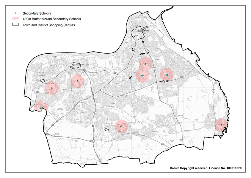
Hot food takeaways can have an adverse impact on the vitality and viability of shopping centres. Vitality refers to how busy a shopping centre is at different times of the day, whilst viability refers to its ability to attract investment. Hot food takeaways are often closed in the daytime leading to dead frontages. An over concentration of Hot food takeaways can therefore lead to a reduction in the attractiveness and character of shopping centres, contributing to a negative impact on the overall vitality and viability.
Hot food takeaways can also generate effects which may have a negative impact on the amenity of neighbouring premises. In assessing proposals for sui generis Hot Food Takeaways, consideration will be given to the potential levels of noise, vibrations, odours, traffic disturbance and litter which can be associated with hot food uses.
The impact on highway safety and levels of anti-social behaviour will be taken into consideration in determining planning applications. Consideration will be given to the existing traffic conditions in the area and the availability of sufficient off-street public parking provision close to the premises. Where there is evidence of existing crime and/or anti-social behaviour in the local area, this information, together with the nature of the proposed use, will be considered when assessing the potential impact of a proposal on any existing crime and anti-social behaviour.
Conserving and enhancing the Natural Environment
The natural environment is one of South Tyneside’s greatest assets and is highly valued by residents and visitors alike. Rich in internationally, nationally, and locally designated sites, as well as those without formal designation, protecting and enhancing the environment that makes South Tyneside special is a key objective of the Local Plan.
The policies in this chapter reflect the multi-functional and diverse roles of the natural environment and aim to deliver Strategic Objectives 10, 11 and 12 which include:
- Protecting the rich geodiversity and ecological assets and enhancing ecological networks within the borough
- Protect, enhance, and increase the provision of green infrastructure across the borough
- Supporting sustainable development whilst maintaining the openness and permanence of the Green Belt
- Enhancing parks, sporting provision and green spaces.
Policy SP21: Natural Environment
The protection and enhancement of the natural environment will be delivered by:
- Ensuring the conservation and enhancement of the natural environment, biodiversity and geological resources and preserving local, national and international priority species and habitats, whilst promoting their restoration, re-creation and recovery and ensuring appropriate protection is given to designated and non-designated assets, including their wider settings
- Supporting the role of natural capital assets and ecosystem services in absorbing carbon emissions and mitigating the likely effects of climate change, taking full account of flood risk, water supply and demand and, where appropriate, coastal change
- Securing net gains for biodiversity, in accordance with Policy 35, including establishing coherent ecological networks that are more resilient to current and future pressures
- Protecting against the loss, damage or deterioration of the borough’s trees, woodland and hedgerows and irreplaceable habitats whilst securing new tree planting and habitat creation, particularly that which would contribute towards flood risk management and contribute to the protection and enhancement of the South of Tyne and Wear Local Nature Recovery Network.
- Providing new and maintaining existing high quality and accessible open space and green and blue infrastructure to create networks of green and blue spaces for people, flora and fauna and allow species adaptation and migration.
The NPPF states that the purpose of the planning system is to contribute to the achievement of sustainable development. The protection and enhancement of the environment is one of the three overarching objectives which must be delivered and implemented through Local Plans to deliver sustainable development.
Local Plans have a statutory obligation to conserve and enhance biodiversity and geodiversity through legislation such as the Conservation of Habitats and Species (Amendment) (EU Exit) Regulations 2019 and the 2006 Natural Environment and Rural Communities Act. The Environment Act (2021) introduces new targets for biodiversity and environmental improvements, Local Nature Recovery Networks, and the introduction of mandatory biodiversity net gain for new developments. The policies within this chapter seek to deliver the statutory duties of the Plan.
The natural environment has a key role to play in the mitigation of climate change and reduction of carbon emissions. The natural capital assets within the environment can support existing ecosystem services and provide nature-based solutions to address these concerns and provide opportunities for nature enhancement. Trees, woodland, and hedgerows are an essential part of the borough’s environment. Individually and in clusters, they provide a habitat for wildlife, enhance natural landscape, help to reduce flood risk, and offer space for recreation and the enjoyment of the natural world. They can also help to lower temperatures, especially in urban areas, and importantly offset CO2 emissions.
The connectivity, quality, and accessibility of green and blue spaces within South Tyneside are essential to ensuring that residents also benefit from these environments. Maintaining a well- planned and strategic network of green-blue infrastructure assets can help to deliver a range of sustainability targets. It can also help to improve the quality of environments by providing attractive and desirable spaces where communities want to live and can assist regeneration within South Tyneside. Furthermore, green and blue space can provide opportunities for sport and recreation which can support active lifestyle choices and improve the health and mental wellbeing of residents.
Biodiversity, Geodiversity and Ecological Networks
Policy 33: Biodiversity, Geodiversity and Ecological Networks
- To ensure the protection and enhancement of biodiversity, geodiversity, and ecological networks, development shall:
- Avoid and minimise adverse impacts upon priority species and habitats and geodiversity in accordance with the mitigation hierarchy
- Secure effective compensation for unavoidable impacts and residual losses
- For development which is likely to adversely affect priority species and habitats and/or geodiversity, planning conditions and/or obligations will be sought to secure the provision, maintenance and monitoring of appropriate mitigation, compensation and/or enhancement measures.
To protect biodiversity, geodiversity and ecological networks from inappropriate development and harm, the following principles of the mitigation hierarchy will be applied when determining planning applications:
- Avoidance
Avoiding adverse effects through good design should be the primary objective of any proposal. This may be achieved through the selection of alternative designs, alterations to site layout, or by selecting an alternative site where no harm to biodiversity would occur. - Mitigation
Adverse effects that cannot be avoided should be adequately mitigated. Mitigation measures minimise the negative impacts of a development, examples include using pollution interceptors to minimise pollution of water courses or timing vegetation clearance to limit impacts on species. Mitigation measures should be secured through planning conditions or obligations and agreed with the Council and any other relevant bodies. - Compensation
Compensatory measures are required for residual losses that cannot be adequately avoided or mitigated and should be used as a last resort in agreement with external decision-makers. If compensating for losses is not possible within the development footprint, or will not generate the most benefits for nature, off site compensatory measures will be required.
Where harm from a proposed development cannot be addressed through the mitigation hierarchy, permission will be refused. The mitigation hierarchy reflects paragraph 180 (a) of the NPPF (2023). The requirement to provide biodiversity net gain is in addition to any mitigation measures required to address potential harm created as a result of the development. Therefore, Biodiversity Net Gain requirements should only be applied after the mitigation hierarchy has been addressed. Regard should be had to Policy 35 the emerging Biodiversity guidance on the application of Biodiversity Net Gain.
Internationally, Nationally and Locally Important Sites
Policy 34: Internationally, Nationally and Locally Important Sites
Internationally Important Sites
- Priority will be given to protecting the borough’s internationally important sites as defined on the Policies Map:
- Special Protection Areas (SPAs)
- Special Areas of Conservation (SACs)
- Ramsar sites
- Any potential Special Protection Areas (SPAs), candidate Special Areas of Conservation (SACs) or proposed Ramsar sites
- Development requiring Appropriate Assessment will only be allowed where it can be determined that the development and its necessary mitigation would not result in adverse effects on the site’s integrity, either alone or in combination with other plans or projects. Where this requirement cannot be robustly demonstrated, development will only be considered acceptable where it meets the following criteria:
- there are no suitable alternatives
- the development is of overriding public interest and appropriate compensatory measures are provided
- Mitigation proposals will need to be agreed with the Council, in consultation with relevant statutory consultees
Recreational Disturbance
- All development for residential use (Use Class Order C3 or C4), including Change of Use and Prior Notifications within 7.2km of the Durham Coast Special Area of Conservation and Northumbria Coast Special Protection Area, as defined on the Policies Map, shall:
- contribute to strategic recreational disturbance mitigation, as identified in the most up to date Mitigation Strategy or any successor document; or
- Agree alternative mitigation measures in agreement with the council and statutory consultees.
- Proposals for leisure and tourism developments that have the potential to result in a likely significant effect on SPA/ SAC coastal designations will be required to undertake an Appropriate Assessment. Where recreational disturbance is identified as a likely significant effect, proposals shall, where applicable:
- contribute to strategic recreational disturbance mitigation, as identified in the most up to date Mitigation Strategy or any successor document; or
- Agree alternative mitigation measures in agreement with the council and statutory consultees.
Nationally Important Sites
- Development that is likely to have an adverse impact on Sites of Special Scientific Interest (SSSI) as defined on the Policies Map, including broader impacts on the national network and the combined effects with other development, will not normally be allowed. Where an adverse effect on the Site’s notified features of interest is likely; the Council will only support an exception where the applicant can demonstrate that:
- The benefits of the development clearly outweigh both likely impact on the features of the site that makes it of special scientific interest, and any broader impacts on the network of SSSIs
- No reasonable alternatives are available
- The appropriate level of mitigation, and/or, where necessary, the appropriate level of compensation, is provided to redress the impact
Locally Important Sites
- Development that is likely to have an adverse impact on Local Sites (Local Wildlife Sites and Local Geodiversity Sites) or Local Nature Reserves as defined on the Policies Map, will only be considered acceptable where it can be demonstrated that:
- The benefits clearly outweigh any significant adverse impact on the site
- No reasonable alternatives are available
- Mitigation, and/or where necessary compensation, is provided for the impact
- Development proposals that would have a significant adverse impact on the value and integrity of a Wildlife Corridor, as defined on the Policies Map, will only be permitted where suitable mitigation and/or compensation, is provided to retain and where possible enhance the value and integrity of the corridor.
South Tyneside has several internationally, nationally and locally important sites. The Council has shown the international and national designations on the Policies Map for reference. The designation and mapped boundaries of these sites are set by other organisations.
International Designations
Within South Tyneside there are three internationally important designations, known as Habitats sites:
- Durham Coast Special Area of Conservation (SAC)
- Northumbria Coast Special Protection Area (SPA)
- Northumbria Coast Ramsar Site
Habitats sites are defined in the NPPF as: “Any site which would be included within the definition at regulation 8 of the Conservation of Habitats and Species Regulations 2017 for the purpose of those regulations, including candidate Special Areas of Conservation, Sites of Community Importance, Special Areas of Conservation, Special Protection Areas and any relevant Marine Sites”.
Conserving and enhancing the Natural Environment
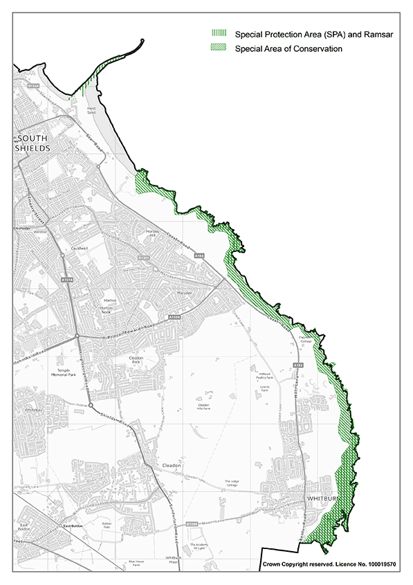
The Conservation of Habitats and Species (Amendment) (EU Exit) Regulations 2019 requires a Habitats Regulations Assessment (HRA) to be undertaken to establish whether likely significant effects are likely to occur. The process involves an initial Screening stage followed by an Appropriate Assessment (AA). Development will not be permitted unless it can show it will not have an adverse effect on the integrity of the designated site, whether direct or indirect, having regard to avoidance or mitigation measures.
Land beyond the boundaries of the Habitats sites may be defined as functional land, where there is an identified functional link between the site and the qualifying species for which the SPA/SAC has been designated. Functional land is considered to contribute to maintaining the designated site or supporting the protected populations’ favourable conservation status. Proposals affecting functional land may also be subject to an HRA/AA.
Proposals for any development within 400m of the Habitats sites are likely to cause additional effects which may be detrimental to the integrity of the site. Effects generated from the proposed use of the site and from the construction process may also need to be considered through Appropriate Assessment at the planning application stage. It is strongly advised that applicants for any development proposals within 400m of a Habitats site should contact the Local Planning Authority for further guidance.
Recreational Disturbance – residential development
All residential developments within 7.2 km of the Durham Coast Special Area of Conservation and Northumbria Coast Special Protection Area and Ramsar site are considered to have a likely significant effect on the integrity of the site through increased recreational use of the coastline.
Where proposals for residential development are within the 7.2km threshold, or for any other proposal which is likely to have a significant effect on any Habitats site, applicants are advised to contact the LPA for advice prior to submission of a planning application.
All new residential developments (Use Class C3 and C4, Change of Use to C3/C4) and Prior Notifications will be expected to contribute towards strategic mitigation measures as set out in the most up to date Mitigation Strategy or successor document, unless suitable alternative mitigation measures can be agreed with the Council in consultation with relevant statutory consultees. The emerging South Tyneside Recreational Mitigation Strategy identifies C3 dwelling house extension and Residential institutions (Use Class C2/C2A) as potentially resulting in recreational disturbance effects. These development proposals will be reviewed on a case-by case basis.
Ongoing monitoring of visitors at the coast will help inform and review the 7.2km zone of influence. The application of the zone should be informed by the latest evidence to ensure likely significant effects are identified and mitigation secured.
Recreational Disturbance – leisure and tourism developments
Leisure and tourism developments within the 7.2km threshold which have the potential to increase recreational use of the Habitats sites, will also be required to undertake a Habitats Regulations Assessment and, where appropriate, provide suitable mitigation. Early consultation with the Local Planning Authority is advised. The emerging South Tyneside Recreational Mitigation Strategy identifies the following development types as possibly resulting in likely significant effects for recreational disturbance:
- Hotels (Use class C1)
- Holiday dwellings (Sui Generis)
- Café/ food outlet
- Visitor attractions
Development proposals within the 7.2km threshold for the above developments will be reviewed on a case-by-case basis to consider links and effects on the coast and to identify whether there is a likely significant effect from recreational disturbance. Where effects are identified, proposals will be expected to contribute to strategic recreational disturbance mitigation.
Where, in agreement with the council, the only identified likely significant effect is recreational disturbance which can be addressed via a financial contribution to strategic mitigation, a full Appropriate Assessment will not be required to be submitted.
If an applicant chooses to present a proposal with individual measures that seek to avoid and mitigate for recreational pressure, they must provide robust evidence that allows the Council to determine whether the adverse effects on the Habitats Site’s integrity has been prevented. It should be recognised that the package of measures funded by the implementation of a mitigation strategy are designed to work together to give certainty that adverse effects will be prevented into the long term.
Where the requirements of the Habitats Regulations are met, any sites secured as compensation for adverse effects on a Habitats site will be given the same protection as the Habitats sites themselves. Residential development would be unlikely to pass an imperative reasons of public interest (IROPI) test, as it can be located elsewhere.
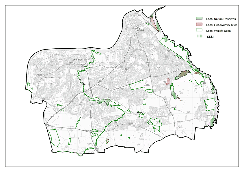
National and Local Designations
Sites of Special Scientific Interest (SSSIs) form a network of nationally designated sites which also underpin sites designated to meet international obligations. There are five SSSIs in South Tyneside. At the time of writing there are 52 Local Wildlife Sites, 6 Local Geodiversity Sites and 7 Local Nature Reserves covering over 500 hectares, all of which contribute to environmental quality and sense of place.
Local Wildlife Sites are not allocated through the planning process and site boundaries and designations may change within the Plan period. For the purposes of the Policies Map, current existing Local Wildlife Sites are illustrated. To ensure that Local Wildlife Sites are fully considered as part of any planning application, developers are advised to contact the local records centre, ERIC NE (Environmental Records Information Centre North East) for up-to-date information.
Regard should also be had to any future Nature Recovery Strategies which are introduced over the Plan period.
Ecological networks comprising designated sites, other habitats, and wildlife corridors and steppingstones are necessary to maintain and enhance biodiversity and prevent fragmentation and loss of connectivity. This is essential if species are to adapt to climate change and if a net gain in biodiversity is to be achieved.
The NPPF requires Local Plans to identify and map wider ecological networks, wildlife corridors and steppingstones. The Wildlife Corridors Network Review (2020) identifies the ecological network throughout South Tyneside, Gateshead and Sunderland. The review identifies wildlife corridors made up of core sites, secondary features, stepping stones and buffers which are components of the wildlife corridor and contribute to the ecological network. The wildlife corridors are identified in Inset .

Local Wildlife Sites are areas of land that are especially important for their wildlife. They are identified and selected locally using scientifically determined criteria and are some of our most valuable wildlife areas. As South Tyneside is such an urban borough there are already significant pressures on our Local Wildlife Sites, it is therefore important to protect such sites of identified ecologically quality from further adverse impacts. Developments should minimise impacts on wildlife corridors, and provide net gains for biodiversity, including by developing these ecological networks whilst ensuring they are more resilient to current and future pressures. Where significant harm cannot be avoided, suitable alternative locations must be considered.
Biodiversity Net Gain
Policy 35: Delivering Biodiversity Net Gain
- Biodiversity Net Gain shall be secured and delivered in accordance with the statutory framework and shall maximise opportunities for the enhancement of ecological networks within South Tyneside and/or the South of Tyne and Wear Local Nature Recovery Strategy Area, and, where appropriate, support nature-based solutions to climate change.
- Where ecologically appropriate Biodiversity Net Gain is demonstrated not to be deliverable onsite, the applicant shall prioritise the delivery of Biodiversity Net Gain off-site in accordance with the following locational hierarchy:
- Within the strategic nature recovery network within South Tyneside.
- Within South Tyneside, outside of the strategic nature recovery network.
- Within the wider South of Tyne and Wear Local Nature Recovery Strategy Area.
- Within Gateshead or Sunderland, outside the strategic nature recovery network
- Within a neighbouring Local Nature Recovery Strategy area, preferentially within the strategic nature recovery network.
- Within a neighbouring National Character Area
- Applicants relying on delivery of off-site Biodiversity Net Gain shall demonstrate to the Local Planning Authority they have used reasonable endeavours to secure that Gain in the most sequentially preferable location as set out in the above hierarchy, before moving onto the next most preferable location. Ecological justification, including submission of supporting evidence, will be required to demonstrate where provision of BNG is not practicable in accordance with the above hierarchy.
- Only where it can be demonstrated that there is no feasible possibility of delivering compensation within the locational hierarchy as set out in Section 2, will the purchase of national credits will be considered an appropriate means of delivering Biodiversity Net Gain.
Biodiversity net gain (BNG) is the achievement of measurable gains for biodiversity through new development and occurs when a development leaves biodiversity in a better state than before development. Biodiversity net gain is required under a statutory framework introduced by Schedule 7A of the Town and Country Planning Act 1990 (inserted by the Environment Act 2021). The principle of BNG is also set out in the NPPF 2023 which states that planning policies and decisions should contribute to and enhance the natural and local environment by minimising impacts on and providing net gains for biodiversity.
Under the statutory framework for biodiversity net gain, every non-exempt grant of planning permission is required to deliver at least a 10% increase in relation to the pre-development biodiversity value of the development granted permission. This increase can be achieved through onsite biodiversity gains, registered offsite biodiversity gains or statutory biodiversity credits.
Policy 35 sets out the expected delivery of BNG in the borough. It seeks to maximise opportunities for the delivery of BNG as close to the development site as possible. Onsite BNG must be appropriate and realistic, taking into account how any publicly accessible areas may be used and the impact that may have on the condition and ecological functionality of the habitat. Whilst onsite BNG should be prioritised, it is considered likely that most significant BNG will need to be delivered offsite.
Policy 35 provides the locational hierarchy as to where South Tyneside Council would expect off-site Biodiversity Net Gain shall be delivered, with locations falling in subparagraph a) being the most preferable, and those falling within subparagraph f ) the least).
The strategic network as referred to in Policy 35 is considered to be the Wildlife Corridor Network as identified in Inset Map 29, or the Local Nature Recovery Strategy within South Tyneside once confirmed. The delivery of Biodiversity Net Gain within this area will receive a higher biodiversity value in the biodiversity metric than they would in other locations as they are considered to be in a more strategic location for nature recovery. It is considered that where desirable, BNG enhancements should seek to enhance and support green and blue infrastructure networks within South Tyneside.
Local Nature Recovery Strategies (LNRS) are a new England-wide system of spatial strategies that will establish priorities and map proposals for specific actions to drive nature’s recovery and provide wider environmental benefits. South Tyneside is part of the South of Tyne & Wear LNRS area with Gateshead and Sunderland. The Council will work closely with all local authorities within the common LNRS area to plan effectively for the recovery of biodiversity across the area and direct action and resources to where they will achieve the greatest benefit for nature.
South Tyneside, Sunderland and Gateshead Councils are working together on a common guidance to support the assessment and delivery of Biodiversity Net Gain. This will give clarity to applicants about what must be submitted as part of a planning application and will set out the Councils’ approach to securing BNG through development.
Trees and Hedgerows
Policy 36: Protecting Trees, Woodland and Hedgerows
- Trees, woodland and hedges shall be protected and suitably retained as an integral part of the design of the development.
- Proposals for new development which would result in unacceptable harm due to the loss of trees, woodland and/or hedgerows will not be permitted, unless it can be demonstrated that:
- An overriding need for development and public benefit clearly outweighs harm to the landscape, ecological value, or the historical importance of the location, or
- Development cannot be relocated elsewhere within the development site, or
- Suitable mitigation and enhancement measures are provided and agreed with the council.
- Where development would involve the loss of ancient or veteran trees it will be refused unless there are wholly exceptional reasons, and a suitable compensation strategy exists.
- Proposals for new development must include new trees and landscape features which:
- Enhance the landscape quality of the development site and the local area
- Enhance biodiversity and connectivity within the Wildlife Corridors; and
- Provide multifunctional environment benefits
Trees and hedges play an important role in supporting the natural environment and wildlife habitats. They make a significant contribution to mitigating the effects of climate change, provide key, such as controlling flood risk, temperature reduction and sequestration of residual carbon, and improving green corridors which allow wildlife to travel between key sites. Trees and hedges also add to the character, appearance and distinctiveness of the local area, and their presence can have a significant and positive effect on the local landscape character.
Where the loss of trees can be demonstrated in accordance with 2(i-iii), and accepted on balance, applicants will be required to provide suitable replacements with adequate provision for maintenance and long-term establishment, including underground rooting infrastructure where appropriate. Replacements shall be planted within the site unless the developer can show exceptional circumstances to support providing the replacement provision elsewhere. In such circumstances off site provision will be secured via planning contributions
Developments should ensure that new streets are tree lined. Trees and hedges, including younger specimens that have the potential to add significant value to the landscape character in the future, should be retained as part of any proposed development and reflected in the proposed development layout.
Development affecting trees on or adjacent to the development site will be required as part of the planning application to undertake a tree survey and arboricultural impact assessment, potentially leading to a tree protection plan and method statement. Surveys and arboricultural impact assessments must be prepared in accordance with British Standard 5837: Trees in Relation to Design, Demolition and Construction, Recommendations (2012), or its successor. This information should guide feasibility and concept design and specify appropriate tree and hedge retention and protection measures, that will allow existing trees and hedges to be sustained in the long term.
Where the loss of a tree or trees is accepted, the applicant should endeavour to replace the lost vegetation on the development site to enhance the character and biodiversity value of the area. Only in exceptional circumstance, where the applicant has clearly demonstrated that this cannot be achieved onsite, would it be considered acceptable to plant elsewhere. In these circumstances a financial contribution towards the planting of trees off site will be required to meet the requirements of this policy.
As a member of the North East Community Forest (NECF), South Tyneside Council is committed to enhancing woodland and increasing its canopy cover, guided by a local forest plan. Where appropriate, development should enhance tree and hedge coverage on sites by planting trees and hedges in line with guidance provided by the NECF and forest plan. The type and quantity of trees should be carefully considered in line with good arboricultural practice and with regard to a changing climate and the need to provide mitigation for that change. Furthermore, planting should be designed in a way to allow sufficient space for new trees to grow to maturity, both above and below ground.
Green and Blue Infrastructure
Policy SP22: Green and Blue Infrastructure
The Green and Blue Infrastructure Network, as identified on the Policies Map, will be high quality, attractive, well managed, resilient and multifunctional. It will deliver a range of social, economic, health and environmental benefits for all by:
- Maximising the role of Green and Blue Infrastructure to reduce place inequalities and enhancing access for all communities across the borough;
- Working with natural processes to improve quality river and coastal waters and protecting the borough’s vulnerable coastal habitats;
- Supporting the recovery of the borough’s nationally and locally designated sites and supporting the Local Nature Recovery Strategy;
- Enhancing Green and Blue Infrastructure opportunities for regeneration and wider economic growth;
- Utilising the Green and Blue Infrastructure Network to mitigate the impacts of climate change.
New Development shall support and enhance the identified South Tyneside green and blue infrastructure network by: - Incorporating existing and/or new green and blue infrastructure within the design to ensure proposals are integrated into the surrounding area and enhance the wider green and blue infrastructure network. Where relevant, development proposals shall strengthen green and blue infrastructure connections with neighbouring authorities.
- Ensuring new Green and Blue Infrastructure provision is resilient to the effects of climate change and supports opportunities for nature-based climate change adaptation and mitigation
- Where there is an identified need, developer contributions will be sought to improve the quality, use and value of the green and blue infrastructure network
Green and Blue Infrastructure is a network of multifunctional green space and environmental assets which can deliver a wide range of environmental and quality of life benefits for local communities. Protecting and enhancing the borough’s Green and Blue Infrastructure network is essential to delivering a high quality and sustainable environment within South Tyneside. Green and Blue Infrastructure can include parks, private gardens, allotments, hedges, roadside verges, rivers, streams and ponds.
Green and Blue Infrastructure can contribute to the long-term sustainability of the borough by providing resources to help mitigate the impacts of climate change and flooding. It can also maintain and enhance the natural environment by strengthening wildlife corridors and protecting biodiversity assets.
New Green and Blue infrastructure provision should be resilient to the effects of climate change and provide opportunities to mitigate impacts; this can include increasing tree cover and other Green and Blue Infrastructure features to provide shade and reduce flood risk and prioritising nature-based solutions to flooding and coastal resilience.
Developments should prioritise Green and Blue Infrastructure at the design stage and consider the connections between the development and the wider Green and Blue Infrastructure network. Development can provide opportunities to create new Green and Blue Infrastructure assets and corridors; as well as strengthening the existing network. Well thought out, onsite Green and Blue Infrastructure provision can improve the quality and attractiveness of a site and help to mitigate the overall impact of the development.
The South Tyneside Green and Blue Infrastructure Strategy (2023) Improvement Zones which are areas of Green and Blue Infrastructure deficit. To ensure the borough’s Green and Blue Infrastructure network continues to provide good quality and accessible green spaces, developer contributions will be sought to help improve the existing Green and Blue Infrastructure network and support the delivery of new projects within the Improvement Zones.
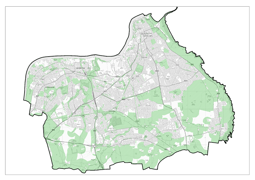
New and existing open space provision
Policy 37: Protecting and enhancing Open Spaces
Existing Open Space and Playing Fields
- Designated areas of open space (as shown on the Policies Map) will be protected and enhanced. Development proposals that would result in the loss in full or in part of designated open space, sports and recreational land and buildings will only be considered acceptable where one of the following criteria is met:
- An up-to-date assessment has been undertaken which clearly shows the open space, sport and recreational land or building is surplus to requirements
- Replacement provision is provided by the proposed development and is equivalent or better in terms of quantity and quality in a suitable location agreed with the Council
- iii. The development is for alternative sports and recreational provision and the benefits clearly outweigh the loss of the current or former use and would positively contribute towards delivering high quality recreational facilities within the borough
- Development proposals that would result in the loss of non-designated open space in full or in part, will only be considered acceptable where such loss would not have a significant detrimental impact upon any of the following criteria:
- the amenity or character of the area
- the level and accessibility of open space provision within the local area
In assessing planning applications against the above criteria in points 1 and 2, regard will be had to the Council’s most recent Open Space Study and Playing Pitch Strategy documents.
New open space and recreation provision
- Where there is a need or the proposed development would generate a need, residential developments of 20 or more dwellings shall contribute towards improving open space, sport and recreation, and green-blue infrastructure provision within the borough by:
- providing onsite open space provision that, where possible, links into and contributes towards the enhancement of the green-blue infrastructure network as set out in Policy SP22
- New or improved open space provision should be provided in accordance with the Council’s most recent Open Space Study, including the quantity and access standards set out in Table 3.
- Where appropriate, large-scale residential development sites, should deliver onsite sport and recreation.
- Developments will be subject to conditions or obligations ensuring that open space is maintained and managed in the long term
- Where the applicant can robustly demonstrate that new on-site provision is not practicable, the following criteria will need to be met:
- Off-site provision shall be provided; or
- A developer contribution shall be provided to the Council for the enhancement of suitable existing open space and or sports and recreation provision within the local area. The level of any contribution should have regard to the Council’s most recently adopted Planning Obligations Supplementary Planning Document.
A key priority for the Council is to promote healthy lifestyles through access to green and blue infrastructure networks, open space, outdoor sport, and leisure facilities. Improved access can be achieved not only by improving the provision and quality of existing assets, but by promoting opportunities to enjoy outdoor recreational activities and open spaces.
Open Space provision for the purpose of Policy 37 is defined as:
- Parks and recreation grounds
- Amenity green spaces
- Playing fields and sports facilities
- Play space (Children)
- Play space (Youth)
- Accessible Natural green open space
- Cemeteries and churchyards
- Allotments.
Development proposals which affect areas of open space or playing field land which are not considered to be surplus to requirements must contribute towards appropriate mitigation to offset the impacts of the development. In assessing whether a site is surplus to local requirements, and to inform appropriate mitigation proposals, regard should be had to any relevant assessments including the most recent Open Space Study or Playing Pitch Strategy. Development proposals effecting sports provision or areas of playing field land should also have regard to Sport England’s most recent Playing Field Policy.
In areas where open space provision is identified as being sufficient in terms of quantity, it may be suitable to seek contributions for quality improvements. The most recent Open Space Study and/or Green and Blue Infrastructure Strategy should be used to help identify mitigation.
Undesignated areas of green space in existing developed areas, including pockets of amenity green space and soft landscaping, can also make a positive contribution to the character of an area. These features and elements help contribute to the perception of open space provision whilst also ensuring an aesthetically pleasing landscape that together provide social and health benefits. Undesignated areas of green space should be protected from development, where possible. The minimum open space quantity and access standards in respect of the local area within which an affected open space lies, will be relevant when using the evidence base documents.
The Open Space Study (2023) identifies locally specific quantity and accessibility standards for South Tyneside, informed by the public consultation undertaken to inform the survey. These standards are set out in Table 3. These standards should be considered in determining new provision / impact upon loss of existing open space.
| Typology | Minimum quantity standards in hectares per 1000 population | Access standard in metres or by straight line walk time |
|---|---|---|
| Allotments | 0.35 | 15 minutes’ walk time (720m straight line) |
| Amenity Green Space (sites above 0.1 ha) | 0.80 | 10 minutes’ walk time (480m straight line) |
| Parks and Recreation Grounds | 1.43 | 15 minutes’ walk time (720m straight line) |
| Play Space (Children) | 0.1 | 10 minutes’ walk time (480m straight line) |
| Play Space (Youth) | 0.1 | 15 minutes’ walk time (720m straight line) |
| Accessible Natural Green Space | 1.0 | ANGSt standards + 20 minutes’ walk time (960m straight line) |
Where the provision of new open space or sport and recreational land is required either through the loss of existing provision or through new residential developments, regard should be had to the latest Open Space Study and or Playing Pitch Strategy to inform the delivery of appropriate provision.
Where onsite provision is to be provided, development proposals must also demonstrate that it will be managed and maintained accordingly. The Council will seek to provide further guidance on the calculation of developer contributions through an SPD.
Proposals for new large-scale residential developments (300+ dwellings) are likely to generate additional demand for sports pitches and should seek to provide onsite sports provision. Where onsite provision is required, the applicant is required to provide the new pitch(es) and make provision for its management and maintenance in consultation with the Council. Regard should be had to the latest Playing Pitch Strategy and early engagement with Sport England, to ensure the most appropriate provision in terms of pitch capacity and demand is provided.
There may be circumstances where onsite provision of open space is not appropriate. In such cases the developer must clearly demonstrate why provision cannot be provided onsite, for example:
- The size of the development could not provide good quality and useful size provision
- The size of the site is unable to provide the type of infrastructure required
- Contributions would be better served supporting existing provision or delivering identified green infrastructure projects in the local area.
Where onsite open space provision is not suitable, off-site provision should be sought as a means of contributing to the green infrastructure network. In these circumstances the applicant should consult the most up-to-date Open Space Study to identify the type of provision to be provided and work alongside the Council to identify an appropriate location.
The Council also acknowledges that it may be more appropriate to seek enhancements to existing sites and improve the quality of provision and/or improve access to alternative sites. In such circumstances, agreement should be sought with the Council on the reason why enhancements are more appropriate and potential mitigation solutions. Similarly, where replacement provision is appropriate, developers should refer to the latest Open Space Study and engage with the Council to agree appropriate provision
The most up-to-date evidence base documents must be consulted when specifying new or enhanced on or off-site open space provision or developer contributions and all such provision or contributions will be secured by planning conditions and/or obligations.
It is acknowledged that most new residential developments are unlikely to be able to support useable on-site sport provision. Therefore, to capture additional demand generated by the new residential development, where relevant, developer contributions should be secured to support playing pitch provision and enhancement within the borough. In such circumstances the Council will have regard to Sport England’s strategic planning tools and the findings of the Playing Pitch Strategy to determine an appropriate amount and type of contribution or provision. This will be reflected in the forthcoming Developer Contributions SPD.
Sports Provision and Playing Pitches
Policy SP23: Sports Provision and Playing Pitches
High quality and accessible sporting facilities that meet the current and future sporting needs of the borough will be delivered by:
- Protecting outdoor sports pitches and playing fields as set out in Policy 37
- Supporting improvements to pitch quality and infrastructure at playing pitch sites where it would contribute to improving the quality of playing pitch provision and accessibility of the site for all users in the borough.
- Enhancing indoor sport and leisure provision to meet the needs of the community.
- Delivering new sporting facilities, playing pitches and infrastructure improvements at the following sites to create key sporting hubs, as shown on the Policies Map:
- Temple Park
- Monkton Stadium
- Providing new playing field provision and supporting quality improvements to playing pitches and onsite infrastructure at the following outdoor pitch sites, as shown on the Policies Map:
- The Dragon Playing Fields, South Shields
- Epinay School, South Shields
- Former Temple Park Junior School
- Oakleigh Gardens, Cleadon
- Cleadon Lane Playing Fields, Whitburn
- The Clock, Hebburn
- School Street, Hebburn
- Lukes Lane Playing Fields, Hebburn
- King George V, Jarrow
- Land adjacent Monkton Stadium
Outdoor sports and leisure facilities are valuable assets for the borough in terms of their function and role in supporting sport and healthy lifestyles, but also to amenity value and contribution to the green infrastructure network.
Where development would result in the loss of playing field land, mitigation measures must be identified and should be considered alongside Policy 37 and Sport England’s Playing Field Policy.
The identification of key sporting hubs is an important means of delivering high quality sports provision within South Tyneside. These key sites will seek to deliver attractive and accessible sports facilities which will encourage increased participation in sport for all. Additional sites identified for improvements will increase the capacity of playing provision in the borough. Improving the overall infrastructure and accessibility of playing pitches by ensuring connections to sustainable transport infrastructure could make pitches more attractive to sports teams.
The Council will support measures to deliver improvements at these sites, notwithstanding the need to consider amenity, design, environmental and highway impacts alongside other relevant policies within the Plan.
Providing for Cemeteries
Policy 38: Providing for Cemeteries
Proposals for a new cemetery or the extension of existing cemetery will be supported provided that:
- Facilities are within proximity to communities to reduce travel
- There would be no adverse impacts on the water quality, water table or flood risk in the area
- There would be no adverse amenity or highways impacts.
Cemeteries can provide a valuable contribution to the borough’s green infrastructure provision and play an important role for communities. Ensuring there is sufficient burial space within South Tyneside to meet the future needs of its communities is an essential role for the Council.
Where appropriate, any new cemetery sites or cemetery extensions should provide opportunities to enhance the borough’s green infrastructure network through tree planting and landscaping and they should also support enhancements to wider ecological networks.
Areas of High Landscape Value
Policy 39: Areas of High Landscape Value
Areas of High Landscape Value (as shown on the Policy Map) will be protected. Development within these designated areas shall:
- Retain and enhance the open and undeveloped character of the area
- Ensure the views from and of key landmarks are retained and, where possible, enhanced
- Encourage accessibility and enhancement of the green infrastructure network and opportunities for habitat enhancement
Development that is considered to have a significant negative impact on the integrity and character of the landscape will be resisted.
National policy provides strong support towards protecting and enhancing valued landscapes. The South Tyneside Landscape Study (2012) considered the landscape, townscape, and seascape of the borough. The study identified three areas where the quality of the landscape and seascape merited additional protection as Areas of High Landscape Value:
- Cleadon Hills
- The summit and scarp of Boldon Downhill
- The Coast – Trow point to the administrative boundary with the City of Sunderland.
Cleadon Hills and Boldon Downhill have been subject to landscape designations in the South Tyneside Local Development Framework; however the study recommends amendments to the boundaries of these designations as some areas of previous designation did not display the qualities needed to merit the designation.
The South Tyneside Landscape Study (2012) identified the original area of High Landscape Value along the coastline. The area of coast previously recommended for inclusion in the landscape designation ran from Trow Point to Whitburn Coastal Park. The Council considers that it is justified to include the area south of Whitburn Coastal Park to the City of Sunderland boundary within The Coast Area High Landscape Value. It is considered that the extended area shares the same essential character, recreational uses, expansive views and limestone cliffs and outcrops.
Developments affecting the identified Areas of High Landscape Value must have regard to the Landscape Character Study and the specific character area guidelines for each area, or any successor document.
Development proposals within the Coast Area of High Landscape Value must consider the unique character, quality, and distinctiveness of the area, particularly in relation to Seascape. Development proposals should consider the Marine Management Organisation (MMO) Seascape Character Assessment for the North East Inshore and Offshore marine plan areas (2018) and should consider the North East Inshore and North East Offshore Marine Plan (2021) Seascape Policy NE-SCP-1.
Agricultural Land
Policy 40: Agricultural Land
- Development proposals will be expected to demonstrate that they avoid the best and most versatile agricultural land (grade 1, 2, 3a). Development of best and most versatile agricultural land will be supported where:
- There are no suitable alternative sites on previously developed or lower quality land
- The need for the development clearly outweighs the need to protect such land in the long term.
- The positive use of agricultural land for farming and agri- environmental schemes will be encouraged. The use of agricultural land shall seek to protect soil quality, minimise soil erosion, retain landscape features such as ponds and hedgerows, and maximise wider environmental benefits.
- Development shall safeguard and utilise on-site soil resources where practicable, maximising the retention of its environmental functions, in accordance with the Defra code of practice for the sustainable use of soils on construction sites.
Soil is a fundamental natural resource on which life depends. It provides many essential services on which we rely including food production, water management and support for valuable biodiversity and ecosystems. As a large store of carbon it also plays a vital role in the fight against climate change.
The quality of agricultural land is classified by Defra and Natural England using the Agricultural Land Classification (ALC). The ALC system classifies land into five grades, with grade 3 subdivided into sub-grades 3a and 3b. The best and most versatile land is defined as Grades 1, 2 and 3a in the NPPF. Most of the agricultural land in South Tyneside is grade 3 or below.
Where development of best and most versatile agricultural land is proposed, applicants will be expected to demonstrate how the proposal complies with Policy 40.
Green Belt
Policy 41: Green Belt
Development proposals within the Green Belt, as shown on the Policies Map, will be determined in accordance with national planning policy.
There is a presumption against inappropriate development in the Green Belt unless very special circumstances can be demonstrated. The NPPF sets out several exceptions:
- Buildings for agriculture and forestry
- Appropriate facilities for outdoor sport, outdoor recreation and cemeteries
- Proportionate extensions or alterations of a building
- Replacement buildings which are not materially larger
- Limited infilling
- Limited affordable housing for community needs
- Partial or complete redevelopment of previously developed land which does not have a greater impact on openness.
The NPPF also sets out other forms of development which may not be inappropriate in the Green Belt including mineral extraction, engineering operations and transport infrastructure.
Conserving and enhancing the Historic environment
The historic environment includes all aspects of the environment resulting from the interaction between people and places through time, including all surviving physical remains of past human activity, whether visible, buried or submerged, landscaped, and planted or managed flora. It includes archaeological sites, historic landscapes, ruins, standing buildings, parks and gardens, semi-natural environments such as wood, heath and moor, or historic land uses such as industry, farming, defence, communications, and tourism.
The historic environment is not just about the past, it is also about the present and the future. It can contribute to quality of life by giving people a sense of place and identity. The historic environment gives the borough a unique competitive advantage, attracts people to live and stay, businesses to invest, and tourists to visit. It essentially plays a significant role in driving growth. The Council recognises the contribution the historic natural and built environment can make to meeting local economic growth ambitions and therefore recognises the importance of its successful management.
The policies in this chapter seek to fulfil the aims of Strategic Objective 9 by:
- enhancing the significance of heritage assets;
- conserving designated and non- designated heritage assets and their settings;
- contributing to sustaining the borough’s local distinctiveness and character.
Heritage Assets
A heritage asset is defined by the NPPF as a building, monument, site, place, area, or landscape identified as having a degree of significance meriting consideration in planning decisions, because of its heritage interest. Heritage assets include designated heritage assets and assets identified by the local planning authority (including local listing). A Designated Heritage Asset is defined by the NPPF as a World Heritage Site, Scheduled Monument, Listed Building, Protected Wreck Site, Registered Park and Garden, Registered Battlefield or Conservation Area designated under the relevant legislation. There are also a number of non-designated heritage assets within the borough which, although not formally designated, positively contribute to the historic environment. Any proposals which would affect non-designated heritage assets should be assessed by carefully weighing the loss or harm caused to the heritage asset against its significance.
Heritage assets, designated and non-designated, are irreplaceable, so any harm or loss will require clear and convincing justification. Heritage policies seek to ensure that the borough’s buildings, monuments, archaeological sites, landscapes, and areas of historic and built heritage significance are preserved and enhanced so that they can continue to make an important contribution to the environment, economy, quality of life and lifelong learning for this and future generations.
South Tyneside has a variety of heritage assets which include:
- Arbeia Roman Fort, part of the Frontiers of the Roman Empire World Heritage Site
- A wealth of mining history
- The Foreshore with its evidence of maritime heritage
- Souter Lighthouse and The Leas
- The Anglo-Saxon Jarrow Monastery and adjacent Jarrow Hall and Anglo-Saxon Farm and Bede Museum.
These (and others) are of value locally, nationally, and internationally, and have significant benefits to the borough’s economy through tourism and the heritage they portray. Their maintenance, enhancement and management are critically important. This cannot be done single-handedly and should be approached strategically, holistically and delivered jointly. Therefore, the Council must take a collaborative approach working with heritage owners and Partners, including national agencies.
The borough’s heritage assets and the protected buildings, structures and areas currently comprise:
- 1 World Heritage Site
- 11 Conservation Areas
- 195 Listed Buildings (accounting for 276 individual buildings)
- 1 Historic Parks and Gardens (consisting of three individual parks)
- 5 Scheduled Monuments
- 192 Locally Significant Heritage Assets (Local List).
The NPPF states that Plans should set out a positive strategy for the conservation and enjoyment of the historic environment, including heritage assets most at risk through neglect, decay, or other threats. All information requirements and assessment work in support of plan- making and heritage protection must be proportionate to the significance of the heritage assets affected and the impact on their heritage significance. At the same time, those making decisions need sufficient information to understand the issues and formulate balanced policies.
The Policies Map illustrates the locations of the borough’s World Heritage Site, Conservation Areas, Historic Parks and Gardens, and Scheduled Monuments. Historic England’s National List for England provides details of all nationally designated heritage assets, whilst the Local List can be viewed on the Council website. These lists are regularly reviewed and updated.
Development proposals which affect the historic environment must sustain the borough’s local distinctiveness and character by safeguarding, conserving, and enhancing designated and undesignated heritage assets and their settings.
An early understanding of the character and the value of the historic environment prevents conflict and maximises the contribution historic assets make to future economic growth and community well-being. In short, a well-cared for and managed historic environment improves everybody’s quality of life.
Heritage Assets
Policy SP24: Heritage Assets
- Development proposals that protect and where possible enhance the rich and diverse historic environment of the borough will be supported
- Development shall, where possible, make a positive contribution to strengthening links between culture and the historic environment through a better understanding of heritage significance.
- Every effort will be made to put heritage assets to viable uses consistent with their heritage significance.
Heritage-Led Regeneration
Heritage-led regeneration encourages public and private sector investment by retaining businesses in an area and by providing an incentive to relocate to it. Understanding how places change, what makes them distinctive, and the significance of their history is the key to regeneration. The historic environment is part of successful regeneration because it contributes to:
- Investment
Historic places attract companies to locate, people to live, businesses to invest and tourists to visit. Market values in historic areas are generally higher than elsewhere. - Sense of place
People enjoy living in historic places, creating greater community cohesion. - Sustainability
Re-use of historic buildings minimises the exploitation of resources. - Quality of life
The historic environment contributes to quality of life and enriches people’s understanding of the diversity and changing nature of their community.
The Council continues to seek opportunities to enhance the historic environment, heritage assets and their settings using planning conditions and, where appropriate, Section 106 agreements.
Development proposals effecting heritage assets in close proximity to coastal areas may also be required to consider North East Inshore and North East Offshore Marine Plan (2021) Policy NE- HER-1: Heritage Assets.
World Heritage Sites
Policy 42: World Heritage Sites
- Development affecting the Hadrian’s Wall World Heritage Site, as shown on the Policy Map, will be encouraged to conserve, promote, and enhance its Outstanding Universal Value, including the authenticity, integrity, and significance of its attributes, and support its management and protection.
- Development within the buffer zone, as shown on the Policy Map and Map 31, and setting shall have regard to the impacts on those values, including views into and from the Site.
- Development likely to have an impact on the Hadrian’s Wall World Heritage Site or its setting will be permitted only where it can be demonstrated that the scheme will conserve those elements which contribute towards its outstanding universal value.
- Development which would cause substantial harm to the significance of the World Heritage Site will be allowed only in wholly exceptional circumstances where it can be demonstrated that the public benefit outweighs the harm.
- Regard must be had to The Hadrian’s Wall World Heritage Site Management Plan, which provides additional guidance for development and conservation within the Site and the Buffer Zone.
World heritage sites are classed as Article 2.3 land in the General Permitted Development Order, which limits permitted development rights and are classified as sensitive areas for the purposes of the Environmental Impact Assessment Regulations.
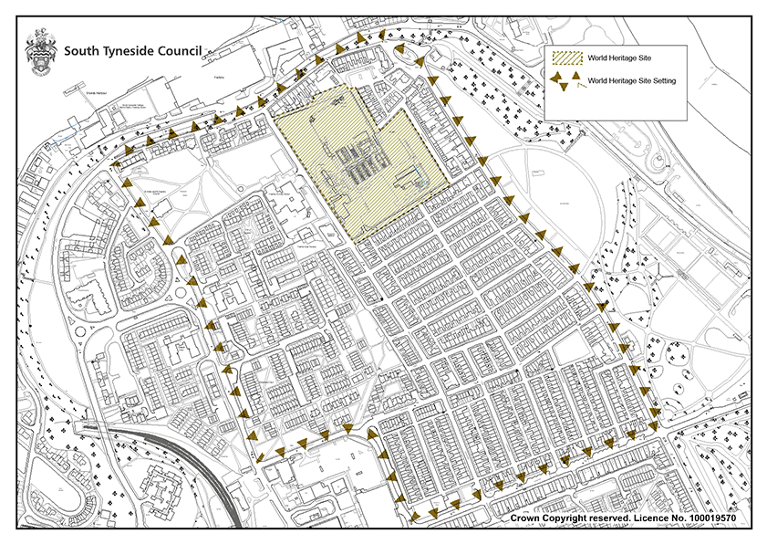
Development Affecting Designated Heritage Assets
Policy 43: Development Affecting Designated Heritage Assets
- Development proposals involving designated heritage assets shall be accompanied by a Heritage Statement that includes an adequate description of the heritage significance of those heritage assets affected.
- Proposals that help to ensure a sustainable future for heritage assets, especially those identified as being at greatest risk of loss or decay, will be supported. The removal of harmful additions and reinstatement of features that have been lost will be actively encouraged.
Alteration, Extension or Change Of Use
- Development involving the alteration, extension or change of use of a designated heritage asset or construction of any structure within its curtilage will only be permitted if the proposal:
- Preserves or enhances its significance as a heritage asset
- Protects existing historically significant hard and soft landscaping, including trees, hedges, walls, fences, and surfaces
- Retains historic plot boundaries and layouts
- Ensures the sensitive and viable use of the building.
Setting
- Development should protect those features of a designated heritage asset’s immediate setting that contribute to its significance, including the space(s) around the heritage asset and the historically significant hard and soft landscaping, including trees, hedges, walls, fences, and surfacing.
Harm
- Where a development will lead to the substantial harm or total loss of a designated heritage asset, applications will be assessed in accordance with National Policy.
- Where it is appropriate to grant consent for demolition, there shall be a condition, or legal agreement, to ensure that demolition shall not take place until a contract for the carrying out of works for redevelopment has been signed and planning permission for those development works has been granted. There may be exceptional cases where this would not be appropriate, for example because the demolition would give rise to a positive effect on the character or appearance of the area.
The advice of suitably qualified persons should be sought by applicants in relation to proposals which are likely to affect heritage assets or their settings. A written heritage statement prepared by a suitably qualified person must accompany all applications that affect designated and non- designated heritage assets or their settings and should detail how its significance has been considered. Through the heritage statement, applicants should show that they understand the significance of the heritage asset and how the changes proposed might impact on it. Sources of information which can be consulted to help find out about the value of a heritage site include the Tyne and Wear Historic Environment Record, local libraries and archives and property deeds. For complex or challenging buildings, the Council would strongly advise the use of a Conservation Accredited Architect or Surveyor. The level of detail required shall be appropriate to the asset’s importance and sufficient to understand the potential impact of the proposal on its heritage significance and/or setting.
Scheduled Monuments
South Tyneside currently has five Scheduled Monuments, protected through the Ancient Monuments and Archaeological Areas Act 1979:
- Marsden Lime Kilns
- Roman Fort, South Shields
- St Paul’s Monastery, Jarrow
- Village of Jarrow
- Lizard Lane Heavy Anti-Aircraft Battery.
To avoid the possibility of damaging a Monument, and therefore carrying out unlawful works, applicants are strongly advised to consult with Historic England in the early planning stages of any intended works.
Registered Parks and Gardens
The Register of Historic Parks and Gardens is compiled by Historic England on behalf of DCMS in recognition of their special historic interest. Such places are an important, distinctive, and much cherished part of our inheritance and the Council has a duty to care for them. Three separately named parks make up South Tyneside’s only entry on this Register: North and South Marine Parks and Bents Park. Local Planning Authorities have a duty to consider the impact of any proposed development on the Parks’ special character in line with the NPPF.
Listed Buildings
Listed Buildings are protected through the Planning (Listed Buildings and Conservation Areas) Act 1990. The Act creates special controls for the demolition, alteration or extension of buildings, objects, or structures of particular architectural or historic interest. Buildings are Listed in their entirety, which means that there will be extra control over what changes can be made to a building’s interior and exterior and includes any object or structure included within the curtilage of the building which, although not fixed to the building, forms part of the land and has done so since before 1st July 1948. This means that fixtures and fittings (e.g. plasterwork, chimney pots, panelling, and fireplaces), outbuildings, boundary walls, and even stone setts can fall within the listing. Historic England’s Listed Buildings and Curtilage Advice Note provides additional guidance.
Some parts of a Listed Building may be more important, or significant, when considering applying for Listed Building Consent. Demolition, alteration, or extension of a Listed Building in such a way that is likely to affect its special architectural or historic interest is only allowed with the consent of the LPA. All likely adverse consequences of development, including physical development such as street furniture and advertising within the street or on frontages immediately adjoining the Listed Building, will also be critically examined. The intention is not to ensure that Listed Buildings are frozen in time, but to ensure that changes are well informed and intelligently managed so that they can sustain their heritage value.
Conservation Areas
Conservation Areas represent some of the borough’s most significant areas of architectural and historic interest. Development in Conservation Areas will be carefully controlled, and the appropriate layout, design, materials, and detailing will be sought. It will be important to assess the impact of the design and layout of new development on the character and appearance of Conservation Areas and planning application must include full design details. In many Areas, Article 4 Directions have been introduced to give extra protection. This means that even minor alterations, for example constructing a porch, replacing windows or re-roofing, could require planning permission.
The character of Conservation Areas derives not only from heritage assets but also from open spaces, attractive vistas, or settings to buildings or features and these will also be protected.
Conservation Area Management Plans are in place for all eleven of the borough’s Conservation Areas, supported by Character Appraisals, which provide detailed guidance on the positive management of Conservation Areas. These documents will be kept under review. Proposals for development affecting a Conservation Area should preserve or, where appropriate, enhance those elements that have been identified as making a positive contribution to its character and special architectural or historic interest. These elements may include buildings, boundary features, other structures, landscape features, open spaces, and setting. Where proposals would lead to harm of Conservation Areas, harm will be assessed as either substantial or less than substantial based on the relative significance of the element affected and its contribution to the significance of the Conservation Area as a whole.
Conservation Areas site boundaries and designations may change within the Plan period. For the purposes of the Policies Map, current existing Conservation Area boundaries are illustrated. To ensure that Conservation Areas are fully considered as part of any planning application, applicants are advised to consider the latest versions of the Council’s Conservation Area Management Plans.
Policy 44: Archaeology
- Development that would affect a known or potential archaeological site, whether designated as a Scheduled Monument or non- designated, will require the results of a desk-based assessment to be submitted as part of the planning application. An archaeological evaluation may also be required to identify the most appropriate course of action. Proposals on sites where archaeological interest has been established by a previous find recorded in the Historic Environment Record will not be determined until the potential impact of the proposed development on archaeological deposits and remains has been adequately assessed and evaluated, and any adverse impacts can be avoided, minimised, or mitigated. In the absence of adequate information, applications will be refused.
- Opportunities for information gain and investigations as part of proposed development will be maximised and added to the Historic Environment Record.
The Council is committed to ensuring important archaeological sites, regardless of designation, are protected from inappropriate development. The Tyne and Wear Historic Environment Record maintains details of all known sites of archaeological interest in the area, including finds, landscapes, buildings, and other aspects of the historic environment. In addition, it contains information on past research and investigations. Applicants are advised to check to see whether their site may contain archaeological remains. There are currently over 2,000 entries within South Tyneside, but these records are constantly being updated.
Archaeological remains are a finite and non-renewable resource which can be readily damaged or destroyed by development. Where development is likely to affect sites of known or potential archaeological interest, an archaeological evaluation may be required, the scope of which the Council will agree in consultation with the Tyne and Wear Archaeologist. This will help to establish the significance of any archaeological remains prior to the determination of any planning application. Where appropriate, planning conditions and planning obligations will be used to secure measures to ensure that the development is acceptable in planning terms.
Where a development affecting archaeological is permitted, the Council will seek to preserve the remains either ‘in situ’ or by record. The former may be achieved through the design of the development while the latter may be achieved by the developer making appropriate and satisfactory provision for the excavation, recording, and reporting of the remains. An archaeological evaluation may be required to identify the most appropriate course of action.
Development Affecting Non- Designated Heritage Assets
Policy 45: Development Affecting Non-Designated Heritage Assets
- Development should conserve and, where possible, enhance the character, appearance and setting of non-designated heritage assets. Proposals that manage development in such a way that sustains or enhances the significant of heritage assets and their settings will be supported.
- Development that could affect previously unrecognised heritage assets will be expected to provide sufficient information for any impacts to be assessed.
- In determining applications that would result in substantial harm to, or total loss of, a non- designated heritage asset or its setting, proposals must demonstrate that the public benefits of the development would outweigh any harm or loss of the heritage asset, based on heritage significance. A balanced judgement will be required having regard to the scale of any harm or loss and the significance of the heritage asset.
- Where development has the potential to include heritage assets with archaeological interest, an appropriate desk-based assessment and, where necessary, field evaluation, will be required to allow any impact to be assessed.
The South Tyneside List of Locally Significant Heritage Assets (November 2011) recognises non designated heritage assets so that they can be properly considered when development proposals are submitted to the Local Planning Authority. This Supplementary Planning Document provides detailed guidance for those wishing to carry out development. The list is not exhaustive and there will be other buildings, structures or spaces that are not currently on the list but may nevertheless contribute to heritage significance and local distinctiveness. As a starting point, applicants are advised to consult the Tyne and Wear Historic Environment Record. The Local List is currently being reviewed as part of a pilot project which will encourage communities to nominate historic buildings and other heritage assets which they value most for inclusion on the local list, helping to protect them through the planning system.
Heritage At Risk
Policy 46: Heritage At Risk
- The Council will work proactively with owners of heritage assets to remove buildings, monuments, and Conservation Areas from the Heritage at Risk register by supporting sustainable reuse of buildings and sympathetic repair. The Council will work proactively with owners to minimise heritage assets becoming at risk. To bring about repairs to heritage at risk the following discretionary measures may be utilised:
- Serving a Repairs Notice
- Serving an Urgent Works Notice
- Article 4 Directions.
Historic England’s Heritage At Risk initiative was launched in 2008 as a way of understanding the overall state of England’s historic sites. It identifies those sites that are most at risk of being lost because of neglect, decay, or inappropriate development.
Since 1998 Historic England have kept a national register of Grade I and II* Listed Buildings, and recently expanded the register to include other heritage assets such as Conservation Areas, Registered Parks and Gardens, Registered Battlefields and Scheduled Monuments.
The Council has maintained its own Grade II Listed Buildings at Risk Register since 2000 and more recently partnered with Historic England and the North of England Civic Trust to deliver an ambitious programme to re-survey the borough’s Grade II Listed Buildings. The aim of the project was to gain a sound understanding of condition and vacancy. The data will be used to identify possible solutions and strategies to bring at risk and vulnerable properties back into good condition. More detail can be found in the South Tyneside Grade II Listed Buildings at Risk report.
The Council will support local communities seeking grant funding from external sources with a view to targeting improvements towards those heritage assets identified as being at risk or vulnerable to risk.
Where buildings are left in an underused and poor condition, there are some discretionary powers available to the Local Planning Authority. These include:
- Urgent Works Notice
- Repairs Notice
The first step is always to negotiate with owners and offer practical advice before taking any formal action. Historic England’s Guide to Enforcement provides detailed advice on the use of these measures, which are included in the 1990 Planning (Listed Buildings and Conservation Areas) Act.
Three Conservation Areas have been identified as At Risk, largely due to small, cumulative alterations which have had an impact on overall character and appearance. Whilst there is detailed guidance on the preservation and enhancement of these areas contained within the Conservation Area Management Plans, many alterations do not require planning consent and owners often choose not to seek advice. Common alterations include the installations of PVCu windows and doors, the demolition of original boundary walls to create parking areas in gardens, and the addition of poorly designed porches. Where it is felt that the exercise of permitted development rights would harm local amenity, the historic environment, or the proper planning of a Conservation Area, the Council will consider introducing additional Article 4 Directions to remove certain permitted development rights. Whilst the use of these Directions does not give the Local Planning Authority powers to require lost features to be reinstated, owners can be given practical advice that will allow them to make the most appropriate changes to their properties. By way of support and assistance, the Council has produced the following guidance:
- South Tyneside Listed Buildings: A guide for owners and occupiers
- South Tyneside Living in a Conservation Area: A guide for residents
- South Tyneside Repair and Maintenance of Traditional Buildings
Article 4 Directions affect hundreds of properties throughout the borough and have been, and will continue to be, successful in preventing alterations which would have a detrimental impact on the character and distinctiveness of South Tyneside’s most valued townscapes.
Well-designed places
The character, distinctiveness and viability of successful places often lies in the quality of the built environment and public realm. Well-designed buildings, places and spaces help to create attractive environments, successful places, and sustainable, healthy communities. The NPPF attaches great importance to the design of the built environment. It states that good design is indivisible from good planning and should contribute positively to making places better for people.
Design is not just about how development looks, but also how it functions and meets the needs of users. The Council is committed to achieving high quality innovative and well-designed buildings and places that respond to the distinctive character of the borough, are inclusive, and enrich the quality of life for all those who live, work, and visit.
Good design facilitates and contributes to local distinctiveness, a sense of place, and civic pride. It improves and enhances the existing environment and helps to attract people, businesses, and investment. The quality of architecture and design inform the impact development will have on the character of the area. High quality development is designed to understand local context and the Council will support development that enhances the distinctive character of the towns and villages and ensure new development positively responds to the environment.
The policies in this Chapter support the delivery of Strategic Objective 10.
Design Principles
Policy 47: Design Principles
All development, including extensions and alterations to existing buildings, shall provide for high quality design that is sustainable, accessible to all users, safeguards residential amenity and contributes positively to the character and visual amenity of the borough’s townscapes, landscapes and seascapes. To ensure the delivery of high quality design, development proposals will be expected to have regard to the following detailed matters:
Context and identity
- Be based on a sound understanding of the context, integrating into the surroundings and responding to natural and historic features, local history, culture and heritage;
- Contribute positively to the sense of place, reflecting and enhancing existing character and distinctiveness;
- Protect any important local views into, out of or through the site; and
- Reflect or improve on the original architectural style of the local surroundings or embrace opportunities for innovative design and new technologies which sympathetically complement or contrast with the local architectural style.
Built Form
- Be appropriate for its context in terms of its building types, street layout, development block type and size, siting, height, scale, massing, form, rhythm, plot widths, gaps between buildings, and the ratio of developed to undeveloped space both within a plot and within a scheme.
- Use appropriate, high quality materials which reinforce or enhance local distinctiveness.
Movement
- Incorporate safe and secure layouts which minimise conflict between traffic, cyclists, pedestrians and equestrians
- Deliver well-considered parking that is sensitively integrated into the built form
- Deliver suitable access solutions for servicing
Nature
- Prioritise opportunities to embed nature within design proposals to ensure high-quality natural environments and support nature based climate change mitigation and resilience.
- Incorporate and retain as far as possible existing natural features including hedgerows, trees, and waterbodies particularly where these features offer a valuable habitat to support biodiversity, aligned with policies in the Natural Environment chapter of the Local Plan
- Include new trees and landscape features which:
- Enhance the landscape quality of the development site and the local area; and
- Enhance biodiversity and improve connectivity with existing Wildlife Corridors.
- Incorporate appropriate soft landscaping to ensure that the development can be satisfactorily assimilated into the surrounding area and provides opportunities to enhance green infrastructure and wildlife networks.
Public Spaces
- Ensure public spaces are accessible to all, are safe and secure by building in natural surveillance; and
- Where relevant, form part of a hierarchy of spaces where relevant to offer a range of spaces available for the community and to support a variety of activities and encourage social interaction.
Homes and Buildings
- Provide homes with good quality internal environments with adequate space for users and good access to private, shared or public spaces;
- Not result in harm to people’s amenity either within the proposed development or neighbouring it through overlooking, overshadowing, loss of light or increase in artificial light or glare, visual intrusion or overdominance; and
- Provide adequate storage, waste and servicing for the use proposed, ensuring they are unobtrusive and well-integrated into the development.
Lifespan
- Provide clarity from the outset as to who will be responsible for the long term maintenance of the various parts of the development with development layouts designed to facilitate such clarity through a clear demarcation between public and private space;
- Promote durability in respect of built development features and landscaped areas through the use of appropriate materials and planting and the laying out of landscaped areas in a manner which facilitates ease of maintenance and appropriate use; and
- Allow for the preservation of design quality by ensuring that between the granting of planning permission and completion of the development that such quality is not diminished by scheme amendments and, where appropriate, provide for the removal of permitted development rights to safeguard against inappropriate extensions and alterations by occupiers of the development.
Development proposals will be expected to satisfy requirements of any adopted local design guide or design code where relevant to the proposal.
The National Design Guide (NDG) forms part of a revised suite of detailed planning practice guidance which should be referred to when drawing up development proposals. The NDG is effectively an urban design manual and sets out the principles and practice of creating well designed, responsive environment. It provides practical planning advice around the ten characteristics informing well- designed places: context, identity, built form, movement, nature, public spaces, uses, homes and buildings, resources, and lifespan. Both the Design Planning Policy Guidance and the National Design Guide are a material consideration in the planning process.
Securing good design is central to good planning and it is essential that new schemes are built to appropriate design and layout standards to protect and enhance the quality and value of the borough. Policy 47 covers all forms of development within the borough and is based around the ten characteristics set out in the NDG.
It is recognised that not all criteria will apply to all forms or scales of development. For example, development proposals for householder extensions will need to have particular regard to the impact of development on character and residential amenity but will not be capable of maximising connectivity or opportunities for pedestrian and cycle movement. As such, the application of Policy 47 should be proportionate to the development proposal.
Whilst it is important to respect local identity, innovation through design can generate new approaches to home design, construction and financing which can speed up the delivery of new homes and provide better options for the wider context of people’s needs. It may not always be desirable to reflect locally distinct patterns of developments, but development must be designed to ensure cohesive and vibrant neighbourhoods.
If required, a Design and Access Statement should clearly show an analysis of the site context, indicating the opportunities and constraints, and justify the principles that have informed the design rationale. Development should be bespoke and respond positively to and be informed by local context and vernacular but without stifling innovation and new technologies which sympathetically complement or contrast with the local architectural style. ‘Standard’ house types or the repetition of layouts, development densities, and the use of construction materials mimicking schemes elsewhere (whether within or outside of South Tyneside) will seldom be acceptable.
South Tyneside Council intends to prepare a Design Code for the borough to support the Local Plan and provide clarity about design expectations for those wishing to carry out development proposals. The Design Code will be tailored to local conditions and priorities, which seek to support well- designed placed by enhancing local character.
Regard should be had to Supplementary Planning Document 9: Householder Developments, or any successor documents which provide guidance for anyone wishing to extend or alter their house or proposing to develop land within the boundaries of their property.
Neighbourhood Plans
Neighbourhood Plans provide an important resource in terms of assessing local character and distinctiveness and Design Codes describe and illustrate the principles guiding future development. Where development proposals fall within a neighbourhood plan area, regard should be had to design policies and any supporting Design Codes should be used to inform development proposals from the outset.
Shopfronts
Policy 48: Shopfronts
Proposals for new shopfronts or alterations to existing shopfronts shall:
- Respect the character of the building on which they are located and their surroundings, as well as the wider street scene in terms of design, colours, materials, lighting, and location. Features that positively contribute to the character of the building and the street shall be retained and, where possible, restored
- Where a shop occupies multiple units, ensure that shopfronts do not run in a continuous horizontal line across the different unit façades. The fascia and the shop windows should be broken up to ensure the features of each unit are not lost
- Ensure that fascia boards are lower than any first floor windows and reflect the predominant height of existing fascia boards on surrounding buildings, where appropriate
- Ensure canopies and blinds over windows and entrances are only for the shading of the shop and shall be retractable
- Always present an active frontage to the street. The following principles will be applied when assessing planning applications for security shutters:
- External or internal Security shutters will not normally be supported on Listed Buildings
- External security shutters will not normally be supported on buildings that are in a Conservation Area
- In other locations external security shutters may be acceptable subject to these being of an open lattice type construction and where shutter boxes are recessed within the shopfront. Shutters should be colour coated to reflect the colour of materials used on the host shopfront or property.
External shutters of a solid or pin hole construction will not be supported unless there is an exceptional need for these on security grounds.
Shopfronts are usually the main advertisement for retailers and when designed well can attract shoppers and encourage them to stay and spend money. Individual shops form part of the wider street scene and a high quality environment can attract other businesses and encourage people to visit.
Responding to and reinforcing local context is important in all shopfront development proposals. The overall composition of multiple shopfronts is often of greatest importance and features such as stallrisers, pilasters and fascia boards can contribute to the character of the building as well as the wider streetscape and existing features should be retained. Fixed canopies can obscure features and are usually inappropriate. The merging of traditional shopfronts can negatively affect the pattern of the street, so it is important to maintain a gap in the fascia boards and a strong separation between the exterior of the two units by a pilaster or a column, where possible.
Security is an important consideration, and the Council does not seek to hinder the ability of businesses to protect their property. However, in recent years many shopfronts have been secured by external, solid roller doors. These are often a cheap and easy solution for security but have a detrimental visual impact on the shopfront and streetscape, presenting a blank wall to pedestrians, and reduce natural surveillance. The housings can also look unsightly when shutters are open. Other methods of security such as lattice grilles, internal shutters and expandable gates in recessed doorways are considered more appropriate as they still provide the necessary security but create a more open frontage and allow light spillage after dark.
Obscuring shop windows with opaque material can have a negative effect on the vitality of the whole street, sometimes because of how the interior of a shop is laid out. Shopfronts should remain active during both the day and night.
Policy 49: Advertisements
- Advertisements shall respect the building or structure on which they are located and/or their surroundings and setting in terms of size, location, design, materials, colour, lettering, amount and type of text, illumination, and luminance, and shall not have a detrimental effect on public safety
- The cumulative impact of adverts will be considered, and a proliferation of advertisements that detrimentally affects visual or aural amenity or public safety will not be acceptable. Advert proposals shall have regard to the following criteria:
- Advertisements shall not obstruct windows, any other sign already located on the building, or significant architectural features such as cornices or scrolls
- In sensitive locations, where a shop or business occupies more than one adjacent unit and each unit has its own distinct identity, the advertisement shall not run between the shopfronts
- Advertisements on Listed Buildings or in Conservation Areas shall respect the heritage significance of the building or area
- Advertisements shall not reduce visibility for users of the highway or accesses onto the highway
- Illumination shall not detract from the amenity of the area or pose a safety hazard to users of the highway
- Advertisements shall not obscure the sight lines of cameras installed for public safety
- Proposals for digital advertisements will be considered against whether the proposal would adversely affect public safety and amenity and shall have regard to:
- The character and appearance of designated and non-designated heritage assets and their settings
- The cumulative impact of adverts on townscape.
Advertisements
Advertising is closely associated with urban life and can be one of the most dominant elements of the environment. In the right context advertisement hoardings can enhance the appearance and vitality of an area. However, where they are poorly designed or located and where too many signs have been installed, they can cause considerable damage to visual amenity by cluttering the built environment and detracting from the quality of an area.
The Town and Country Planning (Control of Advertisements) (England) Regulations 2007 (as amended) explains how advertisements are regulated and what the planning considerations are when assessing applications for advertisement consent.
Digital adverts are by design visually prominent and attention- grabbing with their illuminated images, but they are not suitable for some locations. Luminance, advert display times and how they transition will be controlled using planning conditions. In all instances, digital advertisements should have the levels of candelas reduced between dusk and dawn in the interests of residential amenity, reducing light pollution and road safety.
Energy consumption, operating noise and dimming regimes will also be evaluated to ensure minimal environmental impact in terms of carbon emissions and the impact on dark skies and wildlife. Appropriate onsite renewable generation is encouraged to offset consumption.
When assessing proposals for advertising hoardings, the Council will expect signs and their supporting structures to be of a high quality architectural design that positively enhances its setting. Proposals must therefore be able to demonstrate that they:
- Are designed not to harm the public realm
- Can demonstrate that the rear of the sign is well designed, where applicable
- Do not harm the special character of heritage assets and other visually attractive parts of the borough
- Ensure the location and size of hoardings does not harm amenity or conflict with public safety.
Transport and Infrastructure
South Tyneside’s future growth and environmental sustainability cannot be achieved without infrastructure.
The term infrastructure refers to physical facilities, social and environmental services such as roads and other transport facilities, flood defences, schools and other educational facilities, health facilities, sporting and recreational facilities and open spaces. This is not an exhaustive list and there may be a range of other services and facilities that could constitute infrastructure, which will be required to deliver the Plan.
The policies in this chapter seek to address the aims of strategic objectives 14 and 15.
Policy SP25: Infrastructure
The delivery of the social, environmental, and physical infrastructure that the borough requires will be met by:
- Ensuring that the infrastructure required to support new development is delivered as an integral part of the development at the appropriate stage and, where appropriate, improves any deficiencies in existing provision
- Ensuring that development provides or contributes towards the provision of measures to directly mitigate the impacts of the development and make it acceptable in planning terms and contribute towards the delivery of essential infrastructure identified in the Infrastructure Delivery Plan
- Supporting new and enhancing existing sustainable transport infrastructure to reduce reliance on private vehicles, improving air quality, and addressing other environmental challenges
- Ensuring that the design of infrastructure takes climate- change resilience into account
- Working with operators to maximise telecommunications coverage throughout the borough subject to other relevant considerations
The South Tyneside Vision 2023 – 2043 identifies the delivery of infrastructure and transport improvements as a key requirement to delivering the council’s ambitions. This includes rolling out improved mobile and broadband connectivity, new walking and cycling routes and investment in local roads and public transport.
Whilst the Council has a key role to play in delivering policies and proposals, their implementation will require the combined efforts and investment of a range of Partners. The Council will have a vital role in coordinating the actions and activities of these Partners.
The Plan has been developed in consultation with Partners responsible for infrastructure delivery to ensure that essential infrastructure will be delivered in a timely manner. There remain some areas which will require on-going consultation with the responsible bodies and agencies to identify future, unforeseen needs.
To ensure the infrastructure required is delivered, the Plan is supported by an Infrastructure Delivery Plan (IDP) which provides detail of the infrastructure that is necessary to enable growth to occur. The Council will keep the IDP under review to measure progress. The IDP principally identifies high level strategic infrastructure and does not include site specific infrastructure requirements, which will be dealt with through individual planning applications.
Social and community infrastructure
Policy 50: Social and community infrastructure
- Where there is an identified need, the Council will support the provision of social and community infrastructure of a scale that is appropriate to that need and in a location that is demonstrably accessible to the community it is intended to serve by a range of sustainable travel modes
- To ensure that identified needs for community infrastructure, including health and education, are met, the Council will:
- Support proposals which widen the borough’s cultural, sport, recreation, and leisure offer
- Support proposals of education, training and health providers to meet the needs of local communities
- Require developers to set land aside for the provision of social and community infrastructure and deliver the infrastructure, where there is an identified need or, where appropriate, provide an equivalent financial contribution
- Support multi-purpose uses for, and the enhancement of, existing community facilities
- Where new community facilities are proposed, encourage and support design measures which allow the flexibility for multi- purpose use for a range of community services
- Development which would lead to the loss of community facilities and community services, including public houses, will not be supported unless proposals demonstrate that:
- Through a robust viability statement, that retention of the existing use would not be economically viable
- The proposal would provide an alternative use which is demonstrably of equivalent value to the local community
Along with a variety of Partners, the Council is committed to ensuring that the social and community infrastructure needs of the borough are met.
Access to social and community infrastructure is fundamental to ensuring that residents are part of strong local communities. Community facilities and local services (as defined in the glossary of terms in Appendix 5) provide opportunities for residents to meet and share their interests and access essential services such as education, health care and family support. Access to these facilities can contribute to reducing place and health inequalities across South Tyneside. It is therefore important that these facilities are protected where possible.
Where a need for additional school places is identified because of pressure on places from development, either individually or because of multiple developments within an area, requests for S106 contributions will be made.
If the scale of a development means that demand for school places cannot be met through the expansion of existing schools or academies a S106 contribution may be sought to include land needed to develop a new school in addition to the associated capital costs of establishing the school. Alternatively, the Council may request the developer to provide the land and construct and equip a new school.
Developers are encouraged to work collaboratively with the Council and other key stakeholders regarding the identification and meeting of the social and community infrastructure needs that may arise from development.
Policy SP26: Delivering sustainable transport
- New development will be expected to support sustainable transport and improve accessibility in South Tyneside. The needs of pedestrians, cyclists, bus and rail users, should be prioritised to reduce the need for travel by private vehicle.
- Where appropriate, new development will be supported by a Transport Statement or Transport Assessment and a Travel Plan
- New development should promote sustainable transport and accessibility by:
- Delivering or facilitating sustainable transport modes, including public transport, footpaths and cycle routes that are fully integrated into existing networks
- Having regard to the walking and cycling networks as defined in the Local Cycling and Walking Infrastructure Plan (LCWIP) by ensuring that development has suitable active travel links to the wider network and protecting the integrity of strategic cross- boundary cycling and walking routes
- Provide or contribute towards the provision of new and/or improved sustainable travel infrastructure where the predicted number of additional trips will lead to a cumulative increase in car-based trips
- Where appropriate, improve locations that are less attractive to pedestrians, cyclists, and equestrians, including crossing points at roads
- Ensure sufficient conveniently sited and secure cycle spaces are provided
- Protect and where possible enhance access to Public Rights of Way including the King Charles III England Coast Path National Trail. Proposals that would result in the loss of, or deterioration in the quality of, existing Public Rights of Way will not be permitted unless equivalent alternative provision of a suitable standard is made. Where diversions are required, new routes should be direct, convenient, and attractive, and must not have a detrimental impact on environmental or heritage assets.
- Development shall be designed to meet the needs of public transport users by ensuring:
- Road layouts include direct, convenient, and safe bus routes that are not obstructed by on- street parking
- Bus priority measures are implemented, where appropriate
- All new homes and commercial development are located no more than 400m from a bus stop
- Bus stops shall have appropriately designed shelters, good pedestrian access and be open to public supervision
- Demonstrate how they have sought to maximise opportunities to improve accessibility to Metro stations.
- To ensure the needs and impacts of private vehicles are met, new development proposals should:
- Mitigate impacts on the strategic and/or local highway network arising from the development itself, or the cumulative impacts of development, through the provision of, or contribution towards, necessary and relevant transport improvements, including those secured by legal agreement
- Implement appropriate road safety solutions where applicable
- Ensure that sufficient vehicle parking spaces will be provided in accordance with the Council’s parking standards
Transport issues should be considered from the earliest stages so that opportunities to promote walking, cycling and public transport use are identified and pursued. The Spatial Vision supports accessible and sustainable travel, and the Council wants to ensure that new development facilitates the provision of real travel choices (access to bus stops/ metro stations/walking and cycling networks), need to be integral to the planning of developments from the outset. It is also important that development is designed to promote road safety.
The NPPF states that all development that generates significant amounts of movement should be required to produce a travel plan, and the application should be supported by transport statement or transport assessment so that the likely impacts of the proposal can be addressed. When determining whether a Transport Statement, Transport Assessment or Travel Plan is adequate, applicants are advised to have regard to the criteria provided within the Transport Assessments/Statements, and Travel Plans section of the Validation of Planning Applications in Tyneside (2019).
The aim of the North East Active Travel Strategy (2023) is for active travel to become the natural first choice for short everyday travel and combine it with public transport for longer journeys. More emphasis is being placed on Local Authorities to promote walking and cycling through Active Travel. The Council has recently adopted the Local Cycling and Walking Infrastructure Plan which, subject to appropriate external funding, will enable the Local Authority to ensure growth in terms of Active Travel usage throughout the borough. This will reduce local trips made by car, reduce congestion, and improve air quality and individual health and wellbeing and aligns with the Council’s Physical Activity Strategy (2019) recognises that Strategic cross-boundary cycling and walking routes have been identified in the South Tyneside Local Cycling and Walking Infrastructure Strategy (2021) and are shown on Map 32.
The South Tyneside Green and Blue Infrastructure (GBI) Strategy (2023) recognises that there is crossover between the planning of walking and cycling infrastructure and the planning of the GBI network. The Strategy includes recommended strategic projects which aim to create or upgrade walking and cycling provision.
Where development is proposed for a site near the strategic road network, the local authority will consult with National Highways.
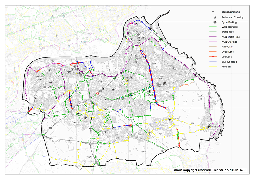
The detailed parking standards will be set out in the Transport and Highways Supplementary Planning Document to be prepared.
The Council is also preparing a Highways and Design Standards document which will contain guidance for the highway management and adoption process, to be read in conjunction with the Manual for Streets.
Improving capacity on the road network
Policy 51: Improving capacity on the road network
The Council will work with key Partners to deliver targeted improvements to the road network. This will include the following:
- Strategic Highway Network projects:
- ‘Junction Improvements (A19/A185/Tyne Tunnel)’
- A19 Lane Gain / Lane Drop Scheme (A185 to A194) – South bound
- Whitemare Pool Junction (A194M / A194 / A184).
- South Tyneside Local Highway Network projects:
- A185 Improvements between the A194 and A19.
- A194 corridor between Lindisfarne and White Mare Pool
- Delivery of associated infrastructure to enable the IAMP development within South Tyneside
- Traffic Signal Upgrades throughout the network using intelligent transport solutions at key junctions
- Localised junction improvements expected to be impacted by development growth
- Improved access to Town Centres associated with the relevant regeneration proposals that are brought forward
- Working with Network Rail to assess the implications of full barrier operation at Tileshed and Boldon level crossings.
The Council’s Economic Recovery Plan identifies the need for resilient road, walking and cycling infrastructure and to invest in transport infrastructure to boost productivity. Proposals for improvements to the highway network will be supported, where they can be demonstrated to be necessary to ensure the safe, efficient, and free flowing movement of people and vehicles across the network.
The Council is working with National Highways and other Partners to ensure a coordinated approach to the delivery of these projects.
The Infrastructure Delivery Plan is a live document which will be updated annually to monitor the delivery of projects and identify new projects.
The Council will continue to investigate the implications of full barrier operation at Tileshed and Boldon level crossings in respect of road safety and traffic flows.
Safeguarding land for Metro and Rail development
Policy 52: Safeguarding Land for Metro and Rail development
- To support metro and rail travel, land is safeguarded as shown on the Policies Map as follows:
- Land for a new Metro station at Mill Lane, Hebburn
- Land for a new Metro / rail station to the north of Follingsby Lane at Wardley Colliery
- The existing (and part former) Tyne Dock mineral line between Tyne Dock and Brockley Whins Metro Stations (including Boldon East curve), for a new Metro link between South Shields and Sunderland
- Land for rail connections (Boldon East Curve, Pelaw Fly- over and Pelaw Chord) for access from South Tyneside to the Leamside Line
- Land for rail connections for the reinstatement of the Leamside Line within the administrative boundary of South Tyneside
- Planning permission for the development of Safeguarded Land will not be granted except where development is temporary or would otherwise not prejudice the ability of the site to be developed in the longer term
The expansion, integration and improvement of local rail and Metro services are a key part of regional transport plans both locally and regionally. Demand for these services remains high as a direct result of increased economic activity. To assist this, the Metro system provides seamless unrestricted access to key urban areas.
The proposed new stations are well situated to serve existing residential developments and future sites identified in the Plan. With appropriate off-road connections for non-motorised users this will provide another means for new and future residents of the borough to travel sustainably.
At Boldon East Curve Junction, the Network Rail line towards Sunderland could be used to provide direct connectivity to South Shields, whilst the Boldon West Junction provides an opportunity to secure direct journeys between South Tyneside and through to Follingsby Park, Washington, and Durham Belmont via the Leamside Line. This would require the construction of a new spur heading west of Fellgate Metro.
The Transport Plan for the North East 2021-2035 supports the delivery of new stations on existing lines and reopen routes including the Leamside Line, alongside Metro network extensions. This will widen access to jobs and training, grow the economy and reduce deprivation.
The Council is supportive of pan- regional network rail upgrades that would improve service and divert local rail onto regional lines and will work with Partners to deliver the Council’s aspirations.
Airport and Aircraft Safety
Policy 53: Airport and Aircraft Safety
Development will be permitted within the Newcastle International Aerodrome Safeguarding Area, as defined on the Policies Map, where it can be demonstrated that it would not prejudice the safety of air traffic and air traffic services.
Development proposals shall consider potential individual and cumulative impacts. Where necessary, mitigation will be required by the developer to either remove or reduce the potential impact upon the safeguarded area to acceptable levels.
The aerodromes safeguarding process is set out the Town and Country Planning (Safeguarding Aerodromes) Direction 2002. Its purpose is to ensure the safe operation of the airport and aircraft within its safeguarding zone is not inhibited by buildings, structures, erections or works that would infringe protected navigation surfaces, or could impair the performance of navigation aids, radio aids or telecommunication systems.
The Civil Aviation Authority has identified Newcastle International Airport as a ‘safeguarded aerodrome’. Aerodrome Safeguarding Areas contain two distinct areas - inner and outer (Map 33). Relevant planning applications within the defined safeguarded area will trigger consultation between the Council, the Civil Aviation Authority, National Air Traffic Service, the Ministry of Defence and Newcastle International Airport. A range of development types trigger the consultation requirement within the inner safeguarding area.
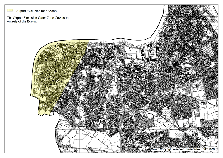
The Newcastle Airport Inner Safeguarding Area extends into the Hebburn/ Fellgate/Jarrow area of the borough. Development proposals which would prejudice the air safety of Newcastle International Airport will not be permitted within this safeguarding zone.
In the outer zone of the Aerodrome Safeguarding Area development proposals involving the erection of one or more wind turbines will trigger the requirement for consultation with Newcastle International. Wind turbines have the potential to affect radar and other Airport navigation systems, as well as being collision hazards in certain circumstances, for which certain mitigating procedures may be required. Therefore, a 30km safeguarding zone (which covers the whole of South Tyneside) is operated by the Airport to ensure that such developments do not adversely impact on the safe operation of aircraft. Primary radar is the airport’s system for tracking the course of aircraft. There is a significant cost to Newcastle International Airport to update the mitigation radar to chart new turbine developments, and the cost of this falls within the scope of the mitigation required by the developer.
Waste and Minerals
Resources should be managed in a sustainable way. Minerals are an important, finite resource which are essential to support sustainable growth and waste should be reduced and re-used or recycled where possible.
This chapter includes policies which meet the aims of Strategic Objective 16.
Waste Facilities
Policy 54: Waste Facilities
- Development of new waste management facilities in South Tyneside will be supported where the proposal can demonstrate that they:
- will assist in meeting an identified need for new waste management capacity to manage specific waste streams over the Plan period or can demonstrate an additional need which cannot be met by existing operational facilities within South Tyneside or the North East;
- contribute to driving the management of waste up the waste hierarchy and do not prejudice the movement of waste up the waste hierarchy;
- assist in moving the management of waste in the borough towards net self- sufficiency and/or make an appropriate contribution to regional net self-sufficiency by managing waste streams as near as possible to their production;
- support opportunities to locate complimentary facilities, such as waste disposal points and treatment facilities near each other;
- are well designed and contribute positively to the character and quality of the area; and
- Individual and cumulative adverse impacts can be fully addressed and mitigated, including:
- Generation of pollutants such as odours, dust, and light
- Noise, traffic generation and vibration
- Harm to water quality and flood risk management
- Land instability; and
- Land use conflict.
- Proposals for waste facilities will be supported in sustainable locations appropriate to the waste management use and where potential adverse impacts on people, biodiversity and the environment can be mitigated. Proposals shall have regard to the following sequential priorities:
- Existing permitted waste management sites, or co-located with other waste management development
- Employment sites suitable for Use Classes B2 (general industry) and B8 (storage and distribution), with the exception of the IAMP
- Sustainable locations on previously developed land and redundant agricultural buildings and their curtilage.
In seeking to achieve sustainable development, emphasis is placed on making the best and most efficient use of land. This includes an efficient and sustainable strategy for waste disposal. Sustainable initiatives such as re-use and recycling should be encouraged over disposal.
Figure 3: The Waste Hierarchy
| Prevention |
| ↓ |
| Preparing for re-use |
| ↓ |
| Recycling |
| ↓ |
| Other recovery |
| ↓ |
| Disposal |
The Council will continue to contribute to climate change mitigation and the reduction of carbon emissions by applying the waste hierarchy of prevention, preparing for reuse, recycling, other recovery, and safe disposal. Waste should be reduced and reused or recycled where possible and disposed of as a last resort. The waste hierarchy has been devised through the Waste Framework Directive and ranks the methods of dealing with waste in order of preference. The National Waste Strategy sets national targets for reducing the amount of waste which ends up in landfill. Waste planning policies should support the waste hierarchy and contribute to achieving national targets.
The Council is part of the South Tyne and Wear Waste Management Partnership. This is a joint approach with Gateshead and Sunderland Councils for the procurement of waste services. Guided by the Joint Municipal Waste Management Strategy (January 2013), the Partnership has developed a strategic solution for the treatment and disposal of residual municipal waste.
The Joint Municipal Waste Management Strategy sets out the Partnership’s objectives, which include reducing the amount of waste generated, reusing waste, recycling and/or composting waste as far as practicable, recovering energy from the remaining waste, and finally disposing of residual waste safely.
The South Tyneside Waste Capacity Study (2023) assesses waste arisings, waste growth forecasts and waste treatment capacity in the borough. The analysis suggests that there is sufficient capacity within the borough over the Local Plan period for much of the forecast waste arisings. South Tyneside does, however, rely on significant recycling capacity in the wider North East Region.
There is currently a significant capacity gap (85,000 tonnes in 2021) for residual Local Authority Collected Waste and Commercial and Industrial waste within South Tyneside, and this is forecast to reduce over time (27,000 tonnes by 2040) due to declining residual arisings. Such a capacity gap is to be expected as residual waste is typically treated in regional scale facilities.
There is significant existing capacity in the wider North East region, and more specifically South Tyneside Council has a residual waste contract with Suez to treat LACW at their Energy from Waste plant at Teesside until at least 2037. This therefore provides security for almost all of the Local Plan period. It is therefore not considered necessary to address this residual capacity gap through the Local Plan itself.
Policy 54 sets out the principles of appropriate waste facility proposals. These principles are key to ensuring waste management infrastructure is delivered in the most sustainable and effective way for the treatment of waste and the avoidance of potential negative impacts. Planning applications must include a supporting statement that demonstrates that the proposal would not have unacceptable impacts on residents, the landscape, wildlife, heritage assets, and existing nearby land uses as well as other committed development proposals.
Protection of Existing Waste Facilities
Policy 55: Existing Waste Facilities
- As shown on the Policies Map, the Council will protect existing waste management sites in the borough from inappropriate development to maintain existing and future levels of waste management capacity and to aid delivery of the Joint Municipal Waste Strategy, unless it can be demonstrated that there is no longer a need for the facility or where the capacity can be better met elsewhere in the borough.
- Development proposals in the vicinity of a waste management site will only be permitted where it can be demonstrated that the proposal would not harm the operations of the waste management site.
- Extension or intensification of existing facilities will only be permitted where it can be demonstrated that the proposal result in no additional adverse effect to the surrounding area.
This policy safeguards those sites required for the delivery of the Joint Municipal Waste Management Strategy and other strategically important sites to protect them against potential future conflict with incompatible uses, as well as protecting existing waste management infrastructure in South Tyneside. This will ensure that sufficient capacity is maintained to manage expected levels of waste over the Plan period. This is important because the predicted future need for additional waste management capacity assumes existing capacity is available (except where known closure has been identified within the Plan period). Should the continuation or potential expansion of sites be affected by non-waste development this would impact on the ability of South Tyneside to manage its waste.
When determining applications for non-waste development within a distance that could affect the potential for waste use on a site, regard will be had to any potential adverse impact the proposed development might have on the future of the site as a location for waste management. If a development is likely to have an unacceptable impact on the future of the site as a location for waste management it will be refused, unless it is demonstrated by the applicant that there is no longer a need for the allocated site as a location for waste management or there is an overriding need for the non-waste development in that location.
To ensure that there is sufficient capacity within the borough to deal with waste arisings, other than those which are to be sent to the Energy from Waste plant at Haverton Hill, Policy 55 seeks to protect these facilities unless there is no longer a need for the facility. In such circumstances, the loss of waste management sites will only be supported where the capacity can be met elsewhere, appropriate compensatory provision is made, or the site is required to facilitate the strategic objectives of the Council.
Policy 56: Minerals Safeguarding
The Council will continue to work with the wider North East authorities to ensure that there are appropriate land-banks for the supply of minerals in the region.
Mineral resources and related infrastructure, as defined on the Policies Map, will be managed and safeguarded from non-mineral related development.
- Minerals Safeguarding Areas
Mineral resources within the Mineral Safeguarding Area will be protected from unnecessary sterilisation by other development. Proposals for non-mineral development within a Mineral Safeguarding Area on sites over 1 hectare will need to demonstrate one of the following:- The mineral concerned is no longer of any value or potential value or is of insufficient extent to be of any economic value
- The mineral can be extracted satisfactorily prior to the non- mineral development
- The non-mineral development is temporary and will be completed and the site restored to a condition that does not inhibit extraction within the timescale that the mineral is likely to be needed
- The overall social, economic, or environmental benefits of the proposed development outweigh the loss of the mineral resource
- It constitutes non-mineral development that is exempt from the safeguarding provisions
- Minerals Infrastructure
Existing minerals infrastructure sites, as identified on the policies map, will be safeguarded from unnecessary loss to non-mineral related development. Proposals for non-mineral development within a minerals infrastructure site will only be supported where it is demonstrated that:- the proposal will not prejudice the current or future use of the site;
- the site is no longer needed for mineral handling, processing, storage and transport; or
- Alternative minerals related infrastructure and/or capacity can be provided at an alternative site.
Defining Mineral Safeguarding Areas and ensuring that known locations of specific mineral resources of local and national importance are not sterilised by non-mineral development is a requirement of the NPPF. Data provided by the Coal Authority shows that majority, but not all, of the borough sits on areas covered by shallow coal. Mineral Safeguarding Areas have also been identified for brick clay, sand, gravel and Magnesian limestone using the British Geological Survey’s Mineral Resource Map which has identified outcrops of basel sands, glacial sand and gravel and an extensive area of Magnesian limestone.
The NPPF states that planning policies should safeguard existing sites for the bulk transport, handling, and processing of minerals. Facilities at the Mercantile Wharf in Jarrow are used by CEMEX for the landing and processing of marine dredged aggregate and at the Port of Tyne by Aggregate Industries for the importation of aggregate minerals in Tyne and Wear. Policy 24: Safeguarding land at CEMEX Jarrow Aggregates Wharf recognises the strategic importance of this site for the mineral industry and seeks to safeguard the site from inappropriate development.
Policy 57: Development Management Considerations for Minerals Extraction
In the context of proposals for minerals extraction, development proposals will be required to demonstrate the extent, quality, and significance of the reserves to be extracted and ensure that:
- The workings of other important mineral deposits are maximised and not prevented
- The proposal can be effectively and sensitively integrated with its surroundings and the character of the landscape, particularly due of changes to landform and topography both during and after extraction
- The operation and restoration of the site does not create land instability and that the quarry slopes and mounds are designed so as not to create instability
- The soil resource is managed in a sustainable way and, where proposals affect the best and most versatile agricultural land, applicants shall demonstrate there is no suitable alternative that provides the same benefits in terms of other environmental considerations, the land could be restored to its previous agricultural land quality or there is an overriding need for the development
- Proposals must ensure the protection of water bodies throughout exploration, the working life of the site and following final restoration. Detailed hydrological and hydrogeological risk assessments will be required to support minerals and waste planning applications.
- The transport of minerals using rail and water is encouraged and, where road transport is proposed, applicants shall demonstrate that transport by rail and water is not practicable or feasible
- Provision has been made for the restoration and aftercare of the proposed site at the earliest opportunity, to high environmental standards.
Minerals extraction has a disruptive impact on land taken for workings, on the landscape character of an area and on the amenities of surrounding communities. To accord with the NPPF, the policy sets out requirements to ensure that operations do not have unacceptable adverse impacts on the natural and historic environments or human health.
The NPPF states that planning policies should ensure that worked land is reclaimed at the earliest opportunity and that high quality restoration and aftercare of mineral sites takes place. There are currently two active quarries in South Tyneside:
- Marsden in South Shields
- Red Barns in West Boldon
Planning permission to extend Red Barns Quarry was granted in 2018 to underpin recent investment at Throckley Brickworks, to the west of Newcastle. The earliest phase of the quarry has already been restored and, under the terms of the planning consent and accompanying legal agreement, there is a detailed plan for the phased restoration of the site to ensure the objectives of landscape amenity and nature conservation of the site continue to be met. Upper Magnesian Limestone is worked at Marsden Quarry. Extraction is currently permitted until 2027, and a scheme to progressively restore the quarry is expected to be completed by 2031.
Implementation and Monitoring
The preceding chapters of this Local Plan identify how South Tyneside will develop over the plan period. Successfully implementing these policies and ensure the delivery of the overall vision for this Plan. This chapter will seek to deliver Strategic Objectives 11, 14 and 15 by:
- Ensuring that development contributes to the delivery of any infrastructure requirements; and
- Successfully secures Section 106 contributions to deliver new infrastructure and necessary improvements
Policy 58: Implementation and Monitoring
This Plan will be monitored against the performance indicators set out within the Local Plan Monitoring Framework (Appendix 3). Should the annual Authority Monitoring Report or other updated evidence suggest policies are not on track to being implemented, the Council will initiate the corresponding contingency measures as set out within the Implementation and Monitoring Framework which may include:
- A review of the delivery of site- specific allocations and investigate any barriers to the development taking place.
- A review of the financial contributions mechanisms, such as negotiating Section 106 Agreements, which may impact on development viability and therefore delivery.
- A review of development management processes, including pre-application discussions and how the Council engages with statutory and other consultees.
- The preparation of supplementary planning documents, development briefs and masterplans to provide clearer guidance on the implementation of certain policies or using the Council’s Compulsory Purchase powers to assemble the land required to support delivery.
- Maintaining the Infrastructure Delivery Plan and continued working with neighbouring local authorities and other Prescribed Bodies to address existing or new cross-boundary development issues.
- Directing additional resources as well as seeking financial and other forms of support from the public, private and voluntary sectors to assist in the delivery of specific policies and proposals.
- Working and engaging with various Partners across the public, private and voluntary sectors.
The successful implementation of the Local Plan relies on a coherent, robust, and flexible monitoring process which will enable the Council to respond to changing circumstances. The principal mechanism for monitoring the performance of the Local Plan will be through the Authority’s Monitoring Report (AMR). The Localism Act 2011 requires Local Authorities to prepare AMRs to assess the implementation of the Local Development Scheme (LDS), and the extent to which policies and proposals set out in local development documents are being successfully implemented.
Policy 59: Delivering Infrastructure
Development will be expected to provide or contribute towards the provision of measures to directly mitigate the impacts of the development and make it acceptable in planning terms and contribute towards the delivery of essential infrastructure identified in the Infrastructure Delivery Plan, subject to it being fairly and reasonably related in scale and kind to the development.
The timing and prioritisation in the delivery of essential infrastructure will accord with the priority needs established through the Infrastructure Delivery Plan.
The purpose of the Infrastructure Delivery Plan (IDP) is to assess what current infrastructure there is in the borough, what is being planned with committed investment and what will be needed in the future.
The Local Plan sets out the policies and allocations to meet the borough’s development needs to 2040. The IDP identifies the infrastructure required to support the delivery of the Local Plan.
This Plan and the IDP has been developed with contributions made by a wide range of key stakeholders and continued consultation with the bodies responsible for infrastructure.
The IDP will be updated as appropriate to take account of changes to and progress with specific development schemes or projects. It deals primarily with public sector-related infrastructure and / or land under public ownership. All sites, including references, correspond to the emerging Local Plan’s site allocations. The Council will continue to work with infrastructure providers on and engage in on- going consultation to identify future, unforeseen needs.
Policy 60: Developer Contributions, Infrastructure Funding and Viability
New development will be required to contribute to infrastructure provision necessary to mitigate its impact.
- Planning Obligations will be sought where it is not possible to address unacceptable impacts using a condition. In determining the level of contributions required from a development, regard will be given to the impact on the economic viability of the scheme.
- When the applicant contends that the economic viability of a new development is such that it is not reasonably possible to make payments to fund all or part of the infrastructure required to support it, this will need to be supported by robust evidence. In this circumstance, the Council may:
- Enter negotiations with the applicant over a suitable contribution towards the infrastructure costs of the proposed development, whilst continuing to enable viable and sustainable development
- Consider alternative phasing, through the development period, of any contributions where to do so would sufficiently improve the viability of the scheme to enable payment.
- Developer contributions may be secured retrospectively where it has been necessary to forward fund development.
- Development proposals will have regard to Supplementary Planning Document: Planning Obligations and Agreements (or its successor document).
New development often creates a need for additional infrastructure or improved community services and facilities, without which development has the potential to cause harmful impacts. The mechanisms for securing the developer contributions needed to address unacceptable impacts include planning conditions and planning obligations.
A planning condition is a condition imposed on a grant of planning permission. They should only be imposed where they are ‘necessary, relevant to planning and to the development to be permitted, enforceable, precise and reasonable in all other respects’.
Planning obligations are legal agreements entered into under section 106 of the Town and Country Planning Act between a Council and a developer or landowner. Planning obligations can only be used where it is not possible to address unacceptable impacts through a planning condition.
The policies and proposals within the Local Plan have been subject to a Whole Plan Viability Assessment. Planning applications that comply with the policies in the Plan will be assumed to be viable. It is up to the applicant to demonstrate whether circumstances justify the need for a viability assessment at the planning application stage. Should a robust viability assessment demonstrate that contribution(s) sought to a proposal would render it economically unviable, then the Council will need to consider, taking into account all of the material considerations, whether it is appropriate to refuse or approve the proposal and whether the viability could be reassessed during the construction phase of the development. In the latter case the Council will need to consider its priorities in selecting the infrastructure for which contributions should be sought.
It is sometimes necessary to forward fund infrastructure projects in advance of anticipated housing growth.
The council will produce further guidance on planning obligations and agreements in support of this Local Plan.
Appendix 1 - List of Superseded Policies
Once adopted, this Plan will fully replace the following adopted development plan documents:
- Core Strategy Development Plan Document (June 2007);
- South Shields Town Centre & Waterfront Area Action Plan (November 2008);
- Hebburn Town Centre Area Action Plan (October 2008);
- Central Jarrow Area Action Plan (September 2010);
- Development Management Policies (December 2011);
- Site-Specific Allocations (April 2012).
Appendix 2 - List of SPDs
- SPD1: Sustainable Construction and Development
- SPD3: Green Infrastructure Strategy
- SPD4: Affordable Housing
- SPD5: Planning Obligations and Agreements SPD6: Parking Standards
- SPD7: Travel Plans
- SPD8: South Shields Riverside Regeneration SPD9: Householder Developments
- SDP10: Westoe Conservation Area Management Plan
- SPD11: West Boldon Conservation Area Management Plan
- SPD12: Whitburn Conservation Area Management Plan
- SPD13: St Paul’s Conservation Area Management Plan
- SPD14: Cleadon Conservation Area Management Plan
- SPD15: East Boldon Conservation Area Management Plan
- SPD16: Hebburn Hall Conservation Area Management Plan
- SPD17: Monkton Conservation Area Management Plan
- SPD18: Cleadon Hills Conservation Area Management Plan
- SPD19: Mill Dam Conservation Area Management Plan
- SPD20: Mariners’ Cottages Conservation Area Management Plan
- SPD21: Locally Listed Heritage Assets
- SPD22: Hot Food Takeaways and Health
- Interim SPD23: Mitigation Strategy for European Sites
Appendix 3 - Implementation and Monitoring
| Policy Ref | LP Policy | Policy Objective | Monitoring Indicator | Trigger for action | Potential action or contingency | Data source |
|---|---|---|---|---|---|---|
| Strategy for Sustainable Development | ||||||
| Policy SP1 | Strategy for Sustainable development to meet identified needs | To deliver sustainable development to secure a better quality of life for everyone now and for future generations |
|
|
|
|
| Policy SP2 | Spatial Strategy for sustainable development to meet identified needs | Sets the identified needs for the borough |
|
|
|
|
| Policy SP3 | Spatial Strategy for sustainable development | Identifies locations for sustainable growth |
|
|
|
|
| Policy SP4 | Housing Allocations in the Main Urban Area | To ensure that there are sufficient new dwellings to meet the needs of the borough’s population |
|
|
|
|
| Policy SP5 | Land at former Brinkburn School | To deliver housing development at former Brinkburn School |
|
|
|
|
| Policy SP6 | Land at former Chuter Ede Education centre | To deliver housing development at Chuter Ede Education Centre |
|
|
|
|
| Policy SP7 | Urban and Village Sustainable Growth Areas | To ensure that there are sufficient new dwellings to meet the needs of the borough’s population |
|
|
|
|
| Policy SP8 | Fellgate Sustainable Growth Area | To ensure that there are sufficient new dwellings to meet the needs of the borough’s population |
|
|
|
|
| Policy SP9 | Strategic vision for South Shields Town Centre Regeneration | Sets out the strategic vision for south Shields town centre |
|
|
|
|
| Policy SP10 | South Shields Riverside Regeneration Area | Sets out the mix of development expected along South Shields Riverside |
|
|
|
|
| Policy SP11 | South Shields Town Centre College Regeneration Site | Facilitate new South Tyneside College development |
|
|
|
|
| Policy SP12 | Fowler Street Improvement Area | Secure improvements to the Fowler Street Area |
|
|
|
|
| Policy SP13 | Foreshore Improvement Area | Facilitate Improvements to South Shields Foreshore |
|
|
|
|
| Policy SP14 | Wardley Colliery | To protect economic development use at Wardley Colliery |
|
|
|
|
| Promoting Healthy Communities | ||||||
| Policy 1 | Promoting Healthy Communities | Ensure an equal distribution of services and amenities and encourage healthy lifestyle choices |
|
|
|
|
| Policy 2 | Air Quality | To ensure development does not worsen air quality |
|
|
|
|
| Policy 3 | Pollution | To ensure new development does not result in increased pollution |
|
|
|
|
| Policy 4 | Contaminated Land and Ground Stability | Sets out the requirements relating to development on contaminated land |
|
|
|
|
| Meeting the challenge of Climate Change, Flood Risk and Coastal Change | ||||||
| Policy SP15 | Climate Change | To provide a strategic approach to mitigating and adapting to climate change |
|
|
|
|
| Policy 5 | Reducing energy consumption and carbon emissions | To support sustainable construction and design to reduce carbon emissions |
|
|
|
|
| Policy 6 | Renewables and Low Carbon Energy Generation | To support and maximise renewable energy generation and use |
|
|
|
|
| Policy 7 | Flood Risk and Water Management | Aims to reduce flood risk and support water management |
|
|
|
|
| Policy 8 | Flood Risk Assessment (FRA) and Drainage Strategy | Sets requirement for FRA where necessary |
|
|
|
|
| Policy 9 | Sustainable Drainage Systems (SuDS) | To reduce the risk of flooding from surface water run-off |
|
|
|
|
| Policy 10 | Disposal of Foul Water | Sets out how foul water must be disposed of |
|
|
|
|
| Policy 11 | Protecting Water Quality | To protect the quality and quantity of surface and groundwater |
|
|
|
|
| Policy 12 | Coastal Change | To protect the coast from inappropriate development and manage coastal erosion |
|
|
|
|
| Delivering a mix of homes | ||||||
| Policy SP16 | Housing Supply and Delivery | To ensure that there are sufficient new dwellings to meet the needs of the borough’s population |
|
|
|
|
| Policy 17 | Specialist Housing – Extra Care & Supported Housing | To ensure the delivery of specialist housing to meet needs |
|
|
|
|
| Policy 18 | Affordable Housing | To ensure a supply of affordable housing of mixed type and tenure |
|
|
|
|
| Policy 19 | Housing Mix | To ensure mixed and balanced communities |
|
|
|
|
| Policy 20 | Technical Design Standards for New Homes | To ensure minimum design standards for new homes |
|
|
|
|
| Policy 21 | Gypsies, Travellers and Travelling Showpeople | To enable the provision of sites and meet the needs of the travelling community |
|
|
|
|
| Building a strong, competitive economy | ||||||
| SP17 | Strategic Economic Development | Sets the strategic priorities for economic development in South Tyneside |
|
|
|
|
| SP18 | Employment Land for General Economic Development | To identify and protect land to meet the economic needs of the borough |
|
|
|
|
| SP19 | Provision of Land for Port and River-Related Development | To identify and protect land for port and river related development |
|
|
|
|
| Policy 22 | Protecting Employment Uses | Protect sites for employment use |
|
|
|
|
| Policy 23 | Employment Development beyond employment allocations | Support for new employment uses outside of allocated areas where appropriate |
|
|
|
|
| Policy 24 | Safeguarding land at CEMEX Jarrow Aggregates Wharf | Safeguarding employment uses at CEMEX Jarrow Aggregates Wharf |
|
|
|
|
| Policy 25 | Leisure and Tourism | Supports the development of cultural, leisure and tourism facilities and sets out where they would be considered acceptable |
|
|
|
|
| Ensuring the vitality of Centres | ||||||
| Policy SP20 | The Hierarchy of centres | Establishes the retail hierarchy of the borough |
|
|
|
|
| Policy 26 | Ensuring the Vitality and Viability in our Retail Centres | Ensure retail uses are retained in town centres and district centres |
|
|
|
|
| Policy 27 | Prioritising Centres Sequentially | Establish need for sequential assessment |
|
|
|
|
| Policy 28 | Impact Assessment | Establish needs for retail impact assessment |
|
|
|
|
| Policy 29 | Local Neighbourhood Hubs | Ensure the vitality and viability of neighbourhood hubs |
|
|
|
|
| Policy 30 | South Shields Market | Support vitality and viability of South Shields Market |
|
|
|
|
| Policy 31 | Evening and Night-time Economy in South Shields Town Centre | Support evening and night time economy in South Shields |
|
|
|
|
| Policy 32 | Hot Food Takeaways | To manage proliferation of Hot Food Takeaways |
|
|
|
|
| Natural Environment | ||||||
| SP21 | Natural Environment | To protect and enhance the natural environment and green infrastructure |
|
|
|
|
| Policy 33 | Biodiversity, Geodiversity and Ecological Networks | To protect biodiversity, geodiversity and ecological networks, and deliver net gain |
|
|
|
|
| Policy 34 | Internationally, Nationally and Locally Important Sites | Protect designated sites within South Tyneside |
|
|
|
|
| Policy 35 | Delivering Biodiversity Net Gain | To secure minimum 10% Biodiversity Net Gain |
|
|
|
|
| Policy 36 | Protecting Trees, Woodland and Hedgerows | To protect trees and hedgerows from development |
|
|
|
|
| SP22 | Green Infrastructure | Aims to protect, enhance and manage the borough’s Green Infrastructure network |
|
|
internal and external stakeholders
|
|
| Policy 37 | Protecting and enhancing Open Spaces & Green Infrastructure | To protect areas of designated open space and secure appropriate mitigation |
|
|
|
|
| SP23 | Sports provision and Playing Pitches | Protect playing pitches and facilitate improvements and new facilities |
|
|
|
|
| Policy 38 | Providing for Cemeteries | Provide new cemetery provision |
|
|
|
|
| Policy 39 | Areas of High Landscape Value | Protect AHLV from inappropriate development |
|
|
|
|
| Policy 40 | Agricultural land | Protect the ‘best and most versatile’ areas of agricultural land from development |
|
|
|
|
| Policy 41 | Green Belt | To protect the borough’s Green Belt from inappropriate development |
|
|
|
|
| Historic environment | ||||||
| SP24 | Strategic Approach for Heritage Assets | To protect, enhance and manage all the borough’s historic environment |
|
|
|
|
| Policy 42 | World Heritage Sites | To protect World Heritage Sites in South Tyneside from inappropriate development |
|
|
|
|
| Policy 43 | Development affecting designated Heritage assets | To conserve, protect and positively enhance designated heritage assets in the borough |
|
|
|
|
| Policy 44 | Archaeology | To ensure development takes full consideration of archaeological remains |
|
|
|
|
| Policy 45 | Development affecting Non- designated Heritage Assets | To conserve, protect and positively enhance non- designated heritage assets in the borough |
|
|
|
|
| Policy 46 | Heritage at Risk | To conserve, protect and enhance heritage assets classified as ‘at risk’ |
|
|
|
|
| Built Environment | ||||||
| Policy 47 | Design Principles | To ensure all developments are designed to a high quality and positively enhance their location and setting |
|
|
|
|
| Policy 48 | Shopfronts | To ensure that shop fronts are of a high standard and protect local amenity |
|
|
|
|
| Policy 49 | Advertisements | To ensure that advertisements are appropriately located within the borough and are of an appropriate scale and size |
|
|
|
|
| Infrastructure | ||||||
| SP25 | Infrastructure | Sets out how Infrastructure should be delivered through the Plan |
|
|
|
|
| Policy 50 | Social and Community Infrastructure | To deliver new and to protect existing community infrastructure |
|
|
|
|
| SP26 | Delivering sustainable transport | To deliver and promote new sustainable transport options |
|
|
|
|
| Policy 51 | Improving capacity on the road network | Identifies schemes to improve capacity on the road network |
|
|
|
|
| Policy 52 | Safeguarding Land for Metro and Rail Development | Identifies land to support future Metro and Rail development |
|
|
|
|
| Policy 53 | Airport and Aircraft Safety | Sets out considerations for Newcastle International Aerodrome Safeguarding Area |
|
|
|
|
|
Waste and Minerals |
||||||
| Policy 54 | Waste Facilities | Sets out the criteria and supporting information require to assess a planning application |
|
|
|
|
| Policy 55 | Existing Waste Facilities | To protect existing waste facilities and sets out the circumstances where they would be considered for alternative uses |
|
|
|
|
| Policy 56 | Minerals Safeguarding | Sets out the criteria that will be used to assess applications submitted within mineral safeguarding areas |
|
|
|
|
| Policy 57 | Development Management Considerations for minerals extraction | Sets out the criteria that will be used to assess applications for mineral extraction |
|
|
|
|
| Policy 58 | Implementation and Monitoring | To set out how the policies within the Plan will be monitored and delivered |
|
|
|
|
| Policy 59 | Delivering Infrastructure | Sets out how the Council expects infrastructure to be delivered |
|
|
|
|
| Policy 60 | Developer Contributions, Infrastructure and Funding Viability | Sets out how developer contributions will be used | Number of applications approved with a S106 agreement of agreement for developer contributions |
|
|
|
Appendix 4: Retail Centre Boundaries
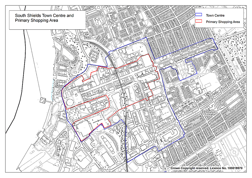
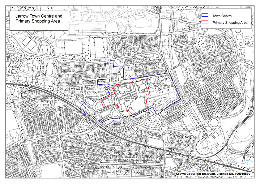
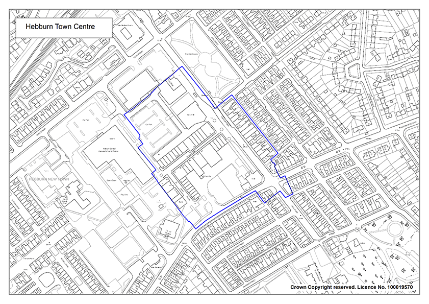
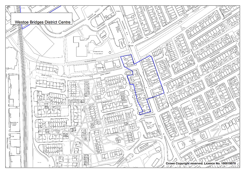
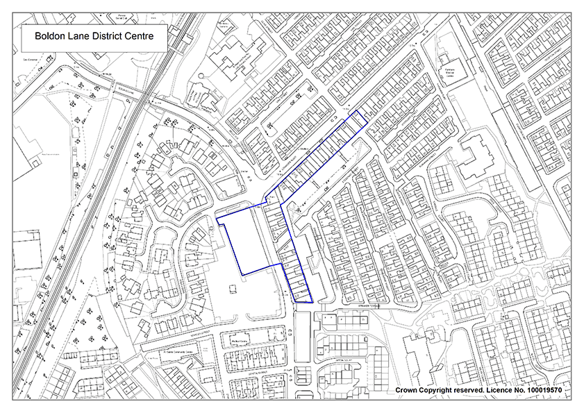
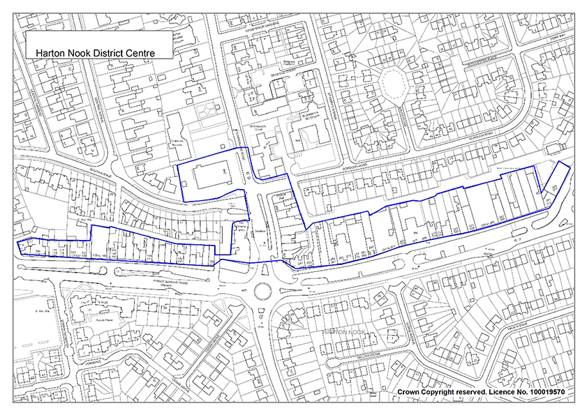
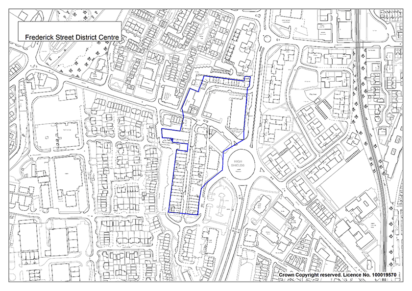
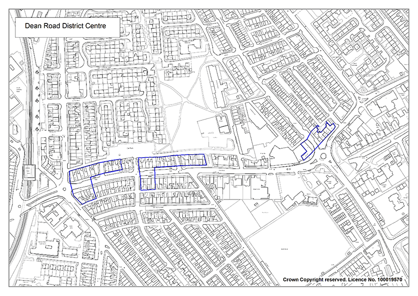
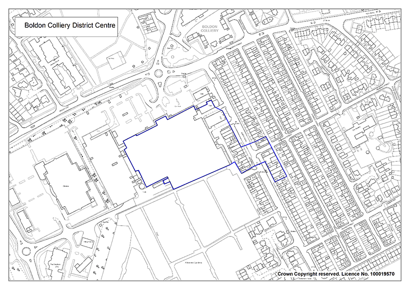
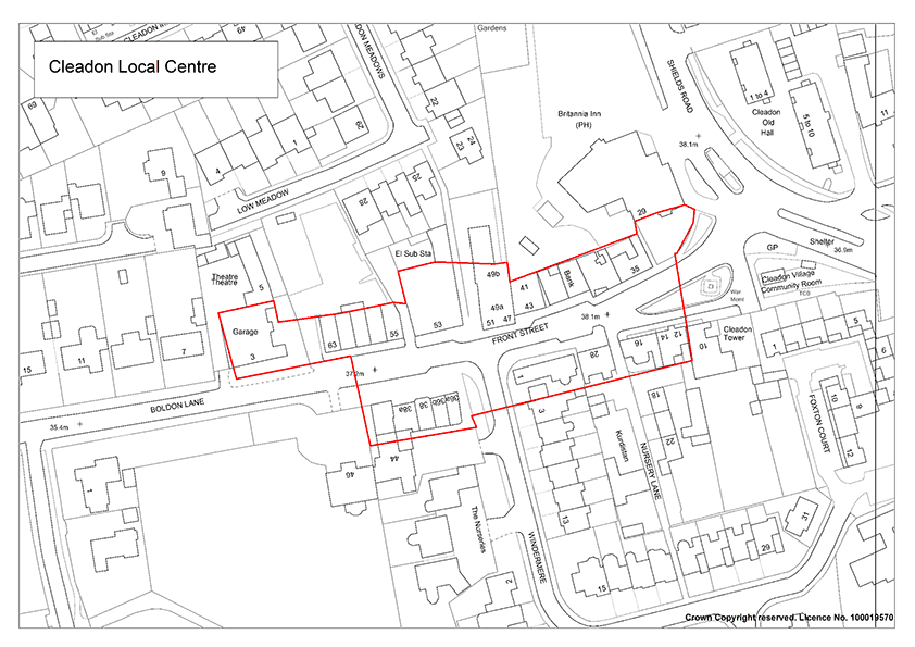
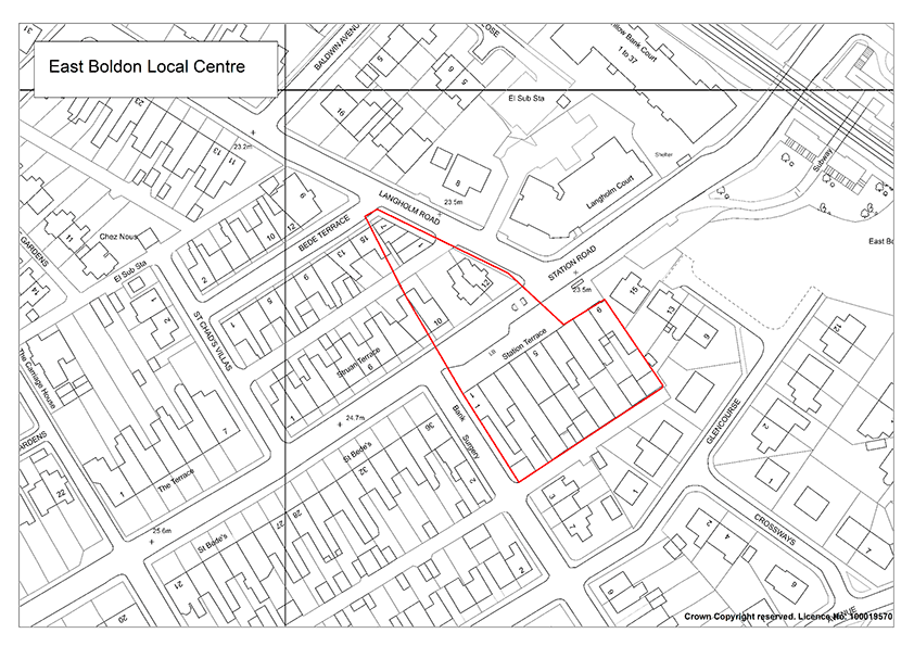
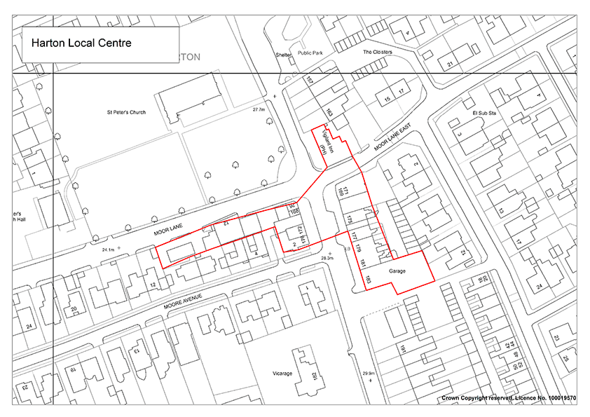
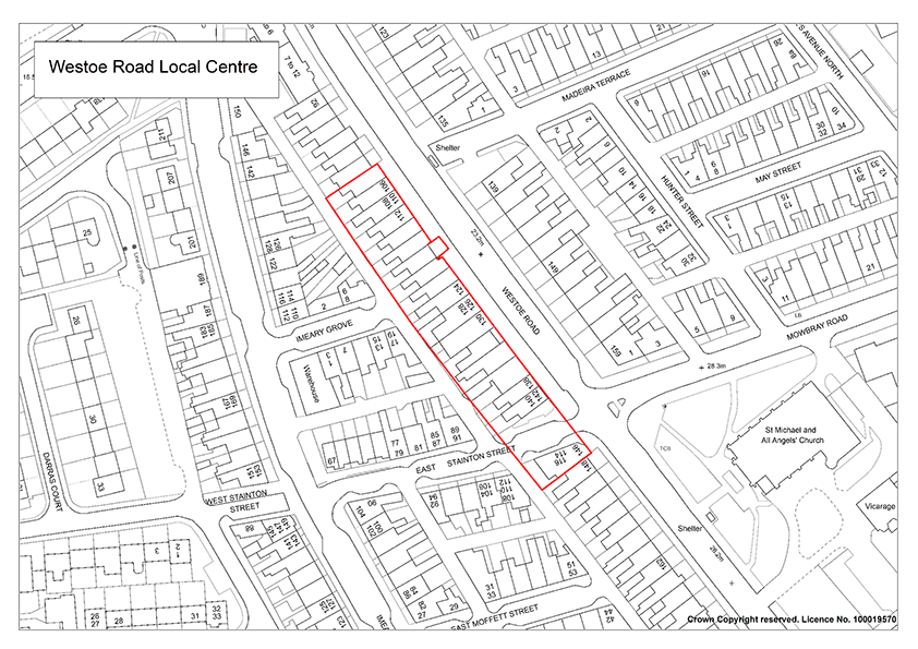
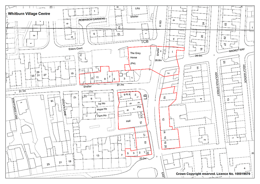
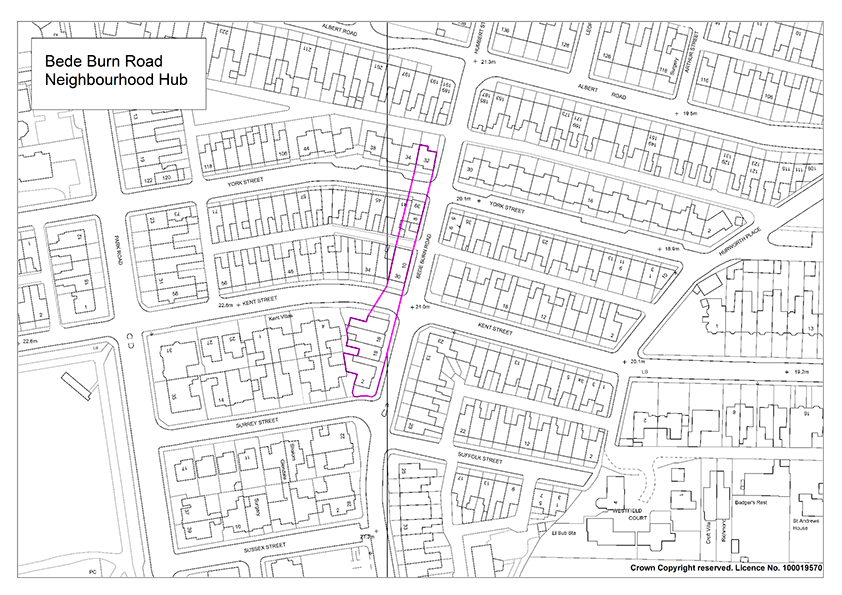
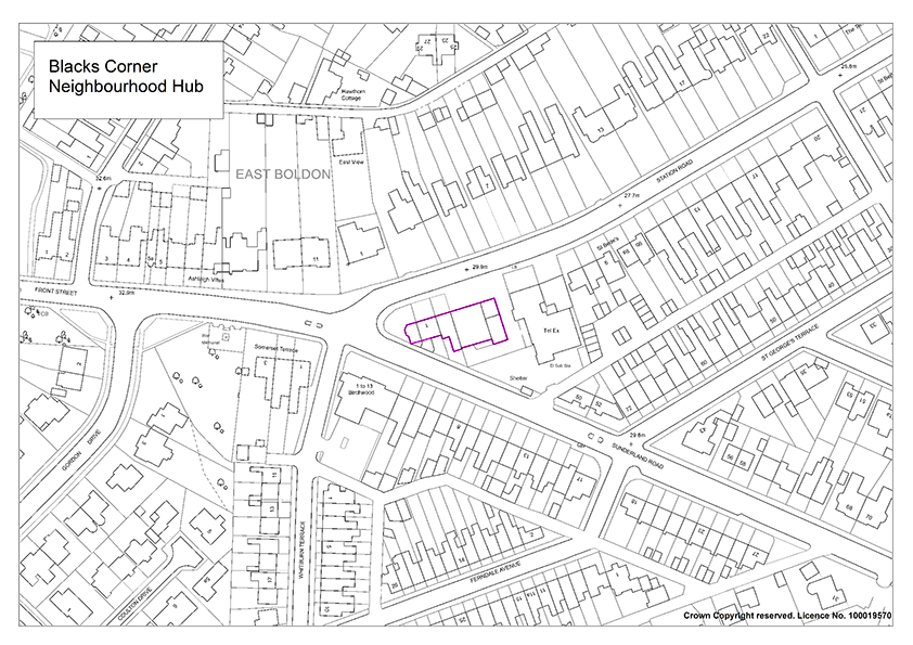
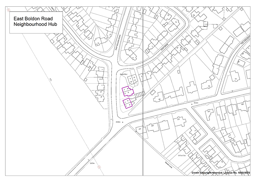
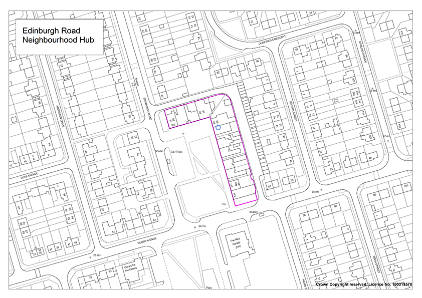
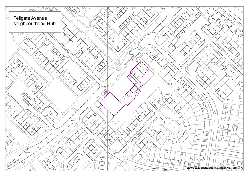
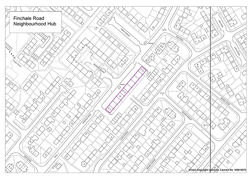
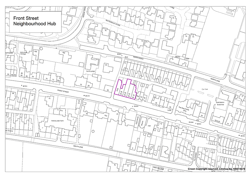
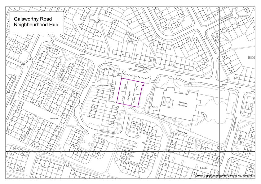
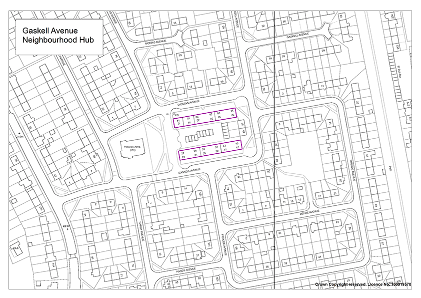
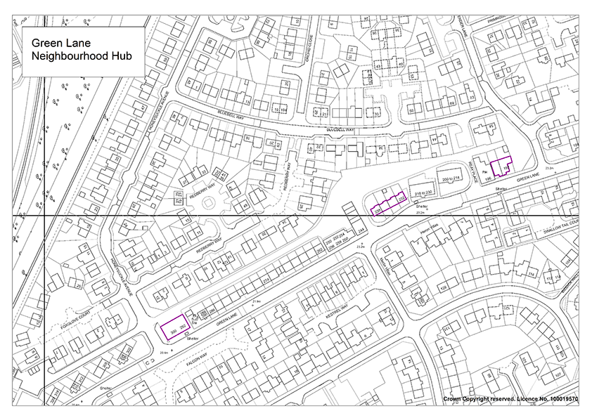
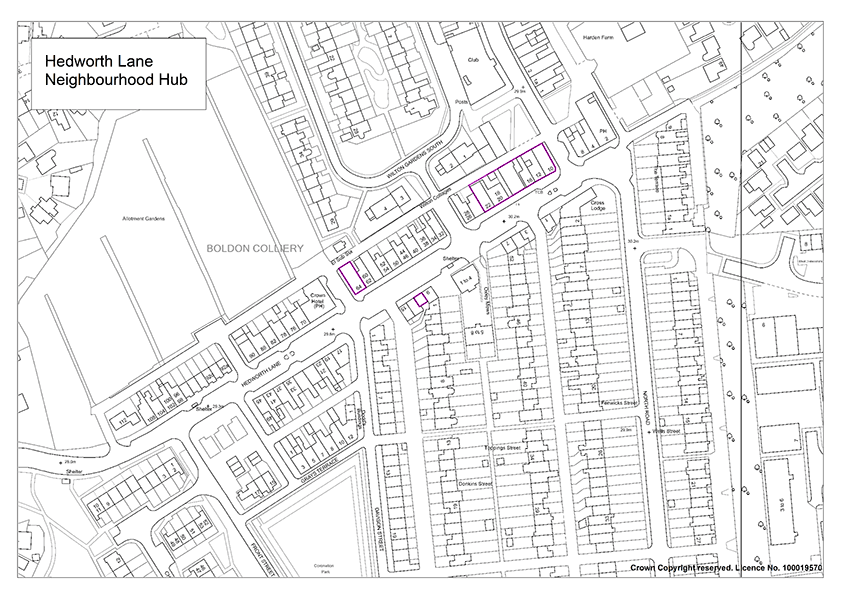
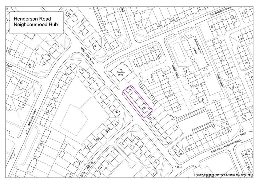
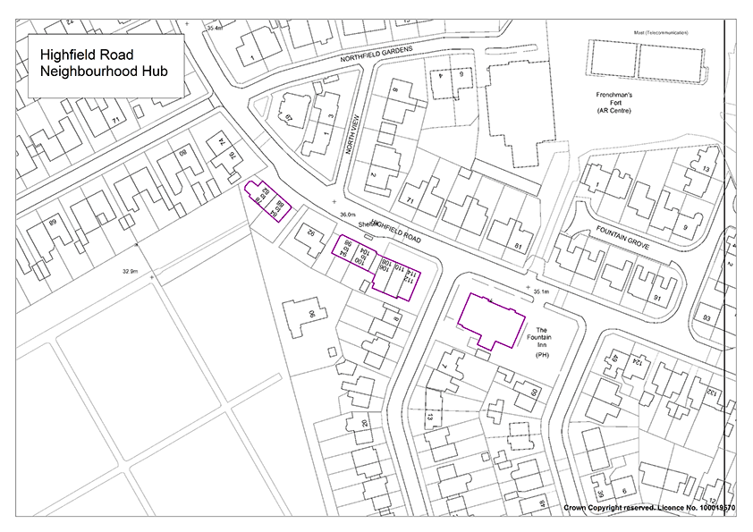
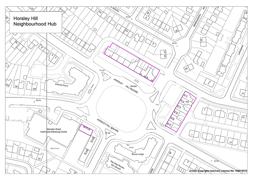
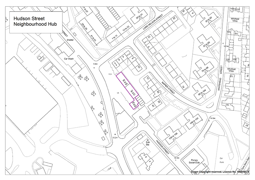

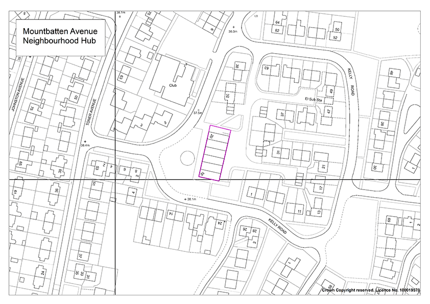
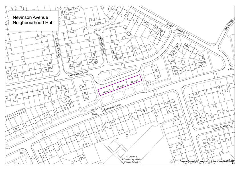
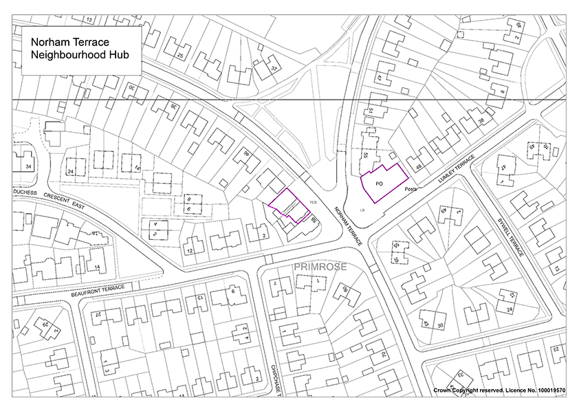
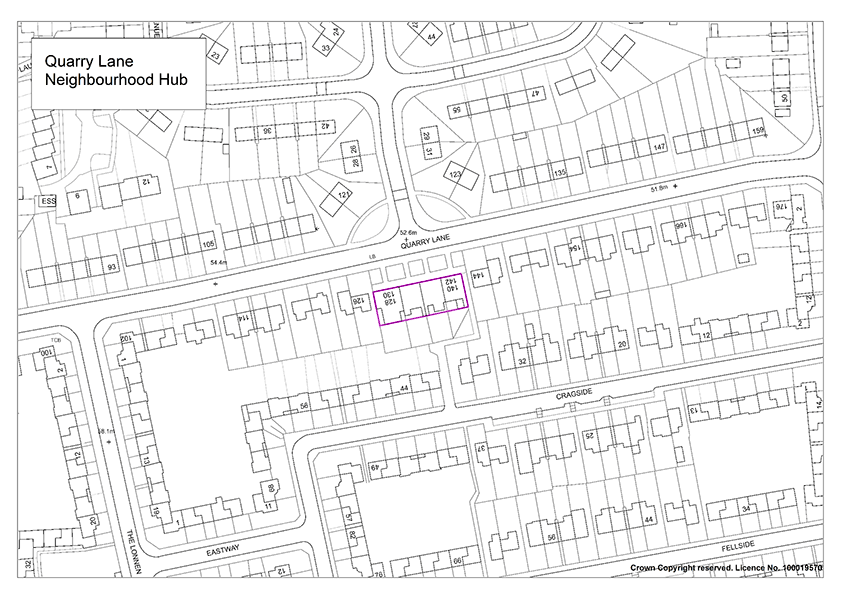
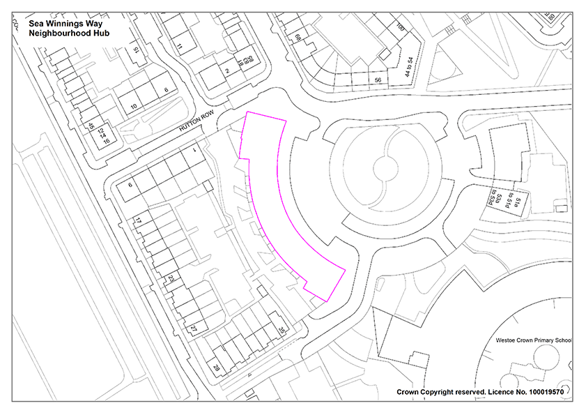
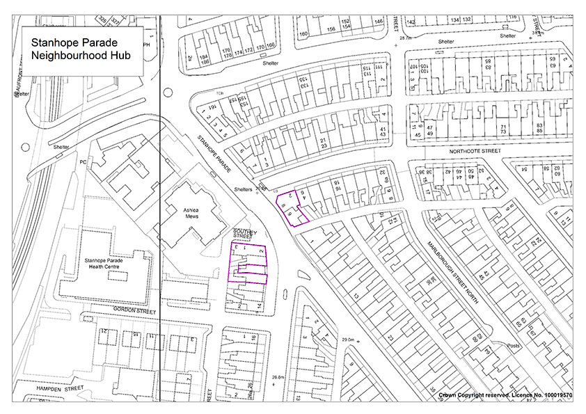
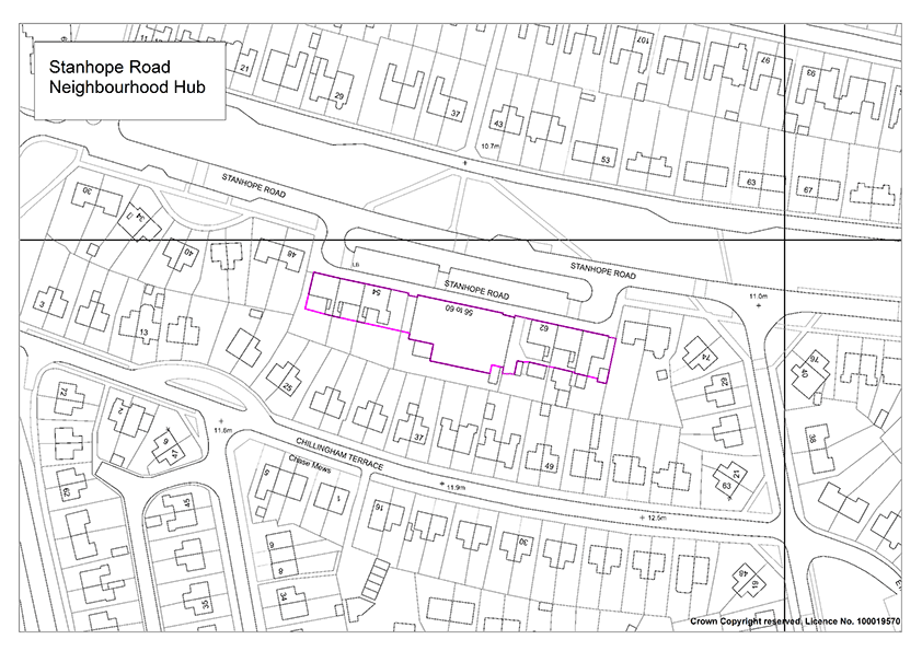

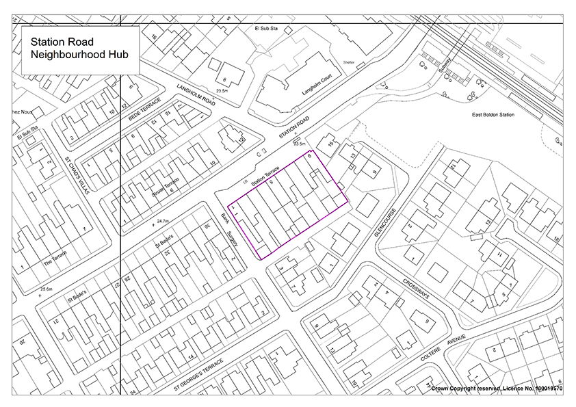
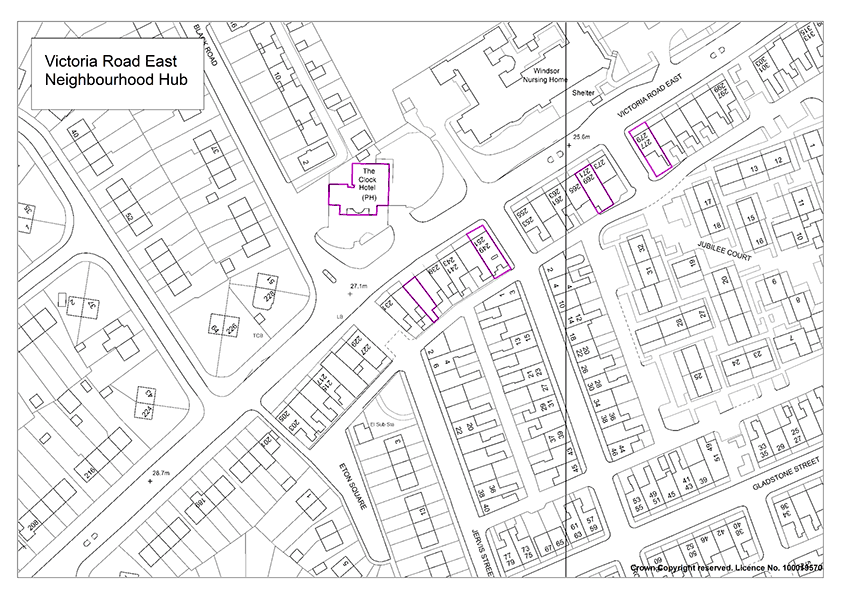
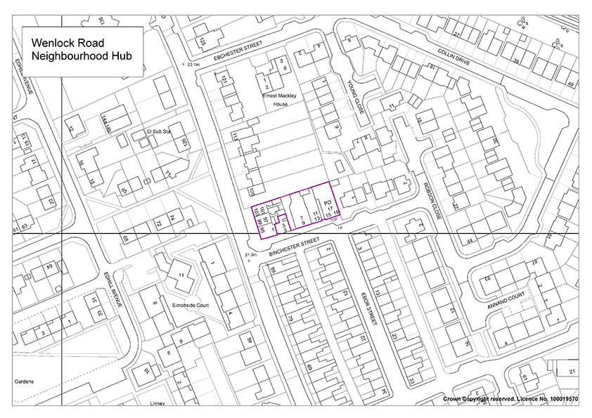
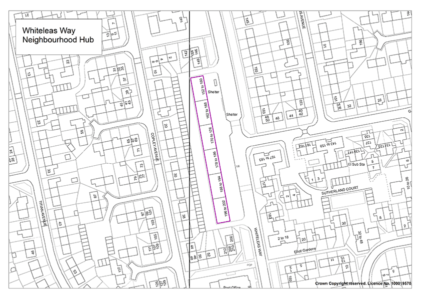
Appendix 5: Glossary
- Accessibility
- Accessibility can be viewed as the “ability to access” and benefit from some system or entity.
- Adoption
- The final confirmation of a Development Plan or Local Development. Document as having statutory status by a Local Planning Authority (LPA).
- Affordable Housing
- Housing provided with a subsidy to enable the sale price or rent to be lower than the prevailing market prices or rents in the locality, and where mechanisms exist to ensure that the housing remains affordable for those who cannot afford to access the market housing. The subsidy will be provided from the public and/or private sector. The definition of ‘affordable housing’ includes key worker housing and shared ownership homes.
- Aggregates
- Sand, gravel, crushed rock and other bulk materials used by the construction industry.
- Amenity
- A positive element or elements that contribute to the overall character or enjoyment of an area. For example, open land, trees, historic buildings and the inter-relationship between them, or less tangible factors such as tranquillity.
- Ancillary use
- A subsidiary or secondary use or operation closely associated with the main use of a building or piece of land.
- Appropriate Assessment
- See Habitat Regulations Assessment
- Arboriculture
- Arboriculture is the management of trees where amenity is the prime objective.
- Archaeological Assessment
- A study of the extent and quality of any archaeological remains that may exist within a site. The study and resulting report(s) must be performed by a suitably qualified professional and will be examined by the Tyne and Wear Archaeologist, from whom advice on the form and nature of the assessment may be sought.
- Archaeological interest
- There will be archaeological interest in a heritage asset if it holds, or potentially may hold, evidence of past human activity worthy of expert investigation at some point. Heritage assets with archaeological interest are the primary source of evidence about the substance and evolution of places, and of the people and cultures that made them.
- Area Action Plan
- A type of Development Plan Document focused upon a specific location or an area subject to conservation or significant change (for example major regeneration).
- Arisings (waste)
- A calculation of the amount of waste produced in the borough.
- Article 4 Direction
- Direction removing some or all permitted development rights, for example within a conservation area or curtilage of a Listed Building. Article 4 directions are issued by local planning authorities.
- Backland Sites
- ‘Landlocked’ sites behind existing buildings, such as rear gardens and private open space, usually within predominantly residential areas. Such sites often have no street frontages.
- Biodiversity
- The whole variety of life on earth. It includes all species of plants and animals, their genetic variation and the ecosystems of which they are a part.
- Brief
- A planning brief can include site-specific development briefs, design briefs, development frameworks and master plans that seek to positively shape future development.
- Brownfield/ Previously Developed Land
- In the sequential approach this is preferable to Greenfield land. It is land which is or was occupied by a permanent structure (excluding agricultural or forestry buildings), and associated fixed surface infrastructure. The definition covers the curtilage of the development. Previously- developed land may occur in both built-up and rural settings.
- Buffer zone
- An area of land separating certain types of development from adjoining sensitive land uses. Often used in relation to World Heritage Sites
- Capacity
- The maximum amount that something can contain.
- Carbon neutral
- Offsetting or compensating for carbon emissions (for example from burning fossil fuels) by schemes such as planting trees to absorb carbon or through careful use of design to promote energy efficiency and to avoid carbon emissions.
- Change of Use
- A change in the way that land or buildings are used (see Use Classes Order). Planning permission is usually necessary to change a “use class”.
- Character
- A term relating to Conservation Areas or Listed Buildings, but also to the appearance of any rural or urban location in terms of its landscape or the layout of streets and open spaces, often giving places their own distinct identity.
- Climate Change
- Long-term changes in temperature, precipitation, wind and all other aspects of the Earth’s climate.
- Climate Change Adaptation
- Adjustments to natural or human systems in response to actual or expected climatic factors or their effects, including from changes in rainfall and rising temperatures, which moderate harm or exploit beneficial opportunities.
- Climate Change Mitigation
- Action to reduce the impact of human activity on the climate system, primarily through reducing greenhouse gas emissions.
- Combined Heat and Power
- The combined production of heat, usually in the form of steam, and power, usually in the form of electricity. Often regarded as a result of human activity and fossil fuel consumption.
- Commitments (or committed development)
- All land with current planning permission or allocated in adopted development plans for development (particularly residential development).
- Community Facilities
- Facilities available for use by the community. Examples include village halls, doctors’ surgeries, pubs, churches and children play areas; may also include areas of informal open space and sports facilities.
- Compulsory Purchase Order
- An order issued by the Government or a local authority to acquire land or buildings for public interest purposes.
- Conditions (or Planning Condition)
- Requirements attached to a planning permission to limit or direct the manner in which a development is carried out.
- Conservation (heritage)
- The process of maintaining and managing change to a heritage asset in a way that sustains and, where appropriate, enhances its significance.
- Conservation Area
- Areas of special architectural or historic interest, the character, appearance or setting of which it is desirable to preserve or enhance.
- Contaminated Land
- Land that has been polluted or harmed in some way making it unfit for safe development and usage unless cleaned.
- Context
- The context may include the physical surroundings of topography, movement patterns and infrastructure, built form and uses, the governance structures, and the cultural, social and economic environment.
- Convenience goods
- Everyday essential items, such as food.
- Culture
- Culture includes arts, media, sports, libraries, museums, parks, and the countryside, built heritage, tourism, and the creative industries.
- Cumulative impact
- A number of developments in a locality or a continuous activity over time that together may have an increased impact on the environment, local community or economy.
- Curtilage
- The area normally within the boundaries of a property surrounding the main building and used in connection with it.
- Decent Homes
- A home must be warm, weatherproof and have reasonably modern facilities in order to be classed as ‘decent’.
- Density
- In the case of residential development, a measurement of either the number of habitable rooms per hectare or the number of dwellings per hectare.
- Design Code
- A set of illustrated design rules and requirements which instruct and may advise on the physical development of a site or area. The graphic and written components of the code are detailed and precise and build upon a design vision such as a masterplan or other design and development framework for a site or area.
- Design Statement
- A design statement can be made at a pre-planning application stage by a developer, indicating the design principles upon which a proposal is to be based. It may also be submitted in support of a planning application.
- Design Guide
- A document providing guidance on how development can be carried out in accordance with good design practice often produced by a local authority with a view to retaining local distinctiveness.
- Designated Heritage Asset
- A World Heritage Site, Scheduled Monument, Listed Building, Protected Wreck Site, Registered Park and Garden, Registered Battlefield or Conservation Area designated under the relevant legislation.
- Development
- Development is defined under the 1990 Town and Country Planning Act as “the carrying out of building, engineering, mining or other operation in, on, over or under land, or the making of any material change in the use of any building or other land.” Most forms of development require planning permission (see also “permitted development”).
- Development Management
- The process whereby a local planning authority receives and considers the merits of a planning application and whether it should be given permission having regard to the development plan and all other material considerations.
- District Centres
- A group of shops and some service outlets serving part of an urban area and providing a geographic focus for it, separate from the town centre but with more variety than local centres
- Dwelling and Dwelling house
- A self-contained building or part of a building used as a residential accommodation, and usually housing a single household. A dwelling may be a house, bungalow, flat, maisonette or converted farm building.
- Ecological Network
- These link sites of biodiversity importance.
- Economic Development
- Development, including those within the B Use Classes, public and community uses and main town centre uses (but excluding housing development).
- Edge of Centre
- For retail purposes, a location that is well connected and up to 300 metres of the primary shopping area. For all other main town centre uses, a location within 300 metres of a town centre boundary. For office development, this includes locations outside the town centre but within 500 metres of a public transport interchange. In determining whether a site falls within the definition of edge of centre, account should be taken of local circumstances.
- Employment Land Review
- The ELR
- Energy from waste
- The conversion of waste into a useable form of energy, often heat or electricity.
- Evapotranspiration
- A term used to refer to the combined processes by which water moves from the earth’s surface into the atmosphere. It covers both water evaporation (movement of water to the air directly from soil, canopies, and water bodies) and transpiration (movement of water from the soil, through roots and bodies of vegetation, on leaves and then into the air). Evapotranspiration is an important part of the local water cycle and climate, as well as measurement of it plays a key role in agricultural irrigation and water resource management.
- Historic England
- The public body that helps people care for, enjoy and celebrate England’s historic environment.
- Environment Agency
- A government body that aims to prevent or minimise the effects of pollution on the environment and issues permits to monitor and control activities that handle or produce waste. It also provides up-to-date information on waste management matters and deals with other matters such as water issues including flood protection advice.
- Environment Impact Assessment (EIA)
- A procedure to be followed for certain types of project to ensure that decisions are made in full knowledge of any likely significant effects on the environment.
- European Site
- This includes candidate Special Areas of Conservation, Sites of Community Importance, Special Areas of Conservation and Special Protection Areas, and is defined in regulation 8 of the Conservation of Habitats and Species Regulations 2010.
- Evidence base
- The information and data gathered by local authorities to justify the “soundness” of the policy approach set out in Local Development Documents, including physical, economic, and social characteristics of an area.
- Flood risk assessment
- An assessment of the likelihood of flooding in a particular area so that development needs and mitigation measures can be carefully considered.
- Footfall
- The numbers and movements of people to provide an indicator of the commercial health of a shopping centre, whilst also informing potential businesses of the likely level of passing trade.
- Full application
- A planning application seeking full permission for a development proposal, with no matters reserved for later approval.
- General Permitted Development Order (GDPO)
- A set of regulations made by the Government which grants planning permission for specified limited or minor forms of development.
- Geodiversity
- The range of rocks, minerals, fossils, soils and landforms.
- Green Belt (not to be confused with the term ‘greenfield’)
- A designation for land around certain cities and large built-up areas, which aims to keep this land permanently open or largely undeveloped.
- Green corridor/wildlife corridor
- Green corridors can link housing areas to the national cycle network, town and city centres, places of employment and community facilities. They help to promote environmentally sustainable forms of transport such as walking and cycling within urban areas and can also act as vital linkages for wildlife dispersal between wetlands and the countryside.
- Green Infrastructure
- A network of multi-functional green space, urban and rural, which is capable of delivering a wide range of environmental and quality of life benefits for local communities.
- Global warming
- The gradual heating of the Earth due to greenhouse gases, leading to climate change and rising sea levels. Renewable energy, energy efficient buildings and sustainable travel are examples of ways to help avert the greenhouse effect.
- Groundwater
- An important part of the natural water cycle present underground, within strata known as aquifers.
- Habitable rooms
- There is no single legal definition of “habitable room”, as its use and meaning is subject to context. For example, the Building Regulations Approved documents provide 3 separate definitions in different parts.
- Habitat
- An area of nature conservation interest.
- Habitats Site
- Any site which would be included within the definition at regulation 8 of the Conservation of Habitats and Species Regulations 2017 for the purpose of those regulations, including candidate Special Areas of Conservation, Sites of Community Importance, Special Areas of Conservation, Special Protection Areas and any relevant Marine Sites.
- Heritage asset
- A building, monument, site, place, area or landscape identified as having a degree of significance meriting consideration in planning decisions, because of its heritage interest. Heritage asset includes designated heritage assets and assets identified by the local planning authority (including local listing).
- Highway
- A publicly maintained road, together with footways and verges.
- Highways England
- An executive agency of the Department for Transport. Highways England is responsible for operating, maintaining and improving the strategic road network of England
- Historic Environment
- All aspects of the environment resulting from the interaction between people and places through time, including all surviving physical remains of past human activity, whether visible, buried or submerged, and landscaped and planted or managed flora.
- Historic Parks and Gardens
- A park or garden of special historic interest. Graded I (highest quality), II* or II. Designated by Historic England.
- Household Waste
- Refuse from household collection rounds, waste from street sweepings, public litter bins, bulky items collected from households and wastes which householders themselves take to household waste recovery centres and “bring sites”.
- Housing Land Availability
- The total amount of land reserved for residential use awaiting development.
- Inclusive Design
- Designing the built environment, including buildings and their surrounding spaces, to ensure that they can be accessed and used by everyone.
- Independent Examination
- The process by which a planning inspector may publicly examine a Development Plan Document (DPD) or a Statement of Community Involvement (SCI), in respect, before issuing a binding report. The findings set out in the report of binding upon the local authority that produced the DPD or SCI.
- Independent Retailer
- A non-multiple retailer operating separately and outside of a larger company chain.
- Infrastructure
- Basic services necessary for development to take place, for example, roads, electricity, sewerage, water, education and health facilities.
- Inset map
- A development plan map showing a particular area of interest on the wider proposals map at a larger, more readable scale.
- Inward Investment
- New business investment or expansion of an existing investment into an area from outside.
- Key Diagram
- The diagrammatic interpretation of the spatial strategy as set out in a local authority’s Local Plan.
- Landfill
- The permanent disposal of waste into the ground, by the filling of man-made voids or similar features.
- Landscape Appraisal
- A method of assessing appearance and essential characteristics of a landscape.
- Landscape Character
- The distinct and recognisable pattern of elements that occur consistently in a particular type of landscape. It reflects particular combinations of geology, landform, soils, vegetation, land use and human settlement.
- Layout
- The distinct and recognisable pattern of elements that occur consistently in a particular type of landscape. It reflects particular combinations of geology, landform, soils, vegetation, land use and human settlement.
- Listed Building
- A building of special architectural or historic interest. Listed Buildings are graded I, II* or II with grade I being the highest. Listing includes the interior as well as the exterior of the building, and any buildings or permanent structures (e.g. wells within its curtilage).
- Listed Building Consent
- Consent required for the demolition, in whole or in part of a Listed Building, or for any works of alteration or extension that would affect the character of the building.
- Local Development Scheme
- The local planning authority’s scheduled plan for the preparation of Local Development Documents.
- Local Listing
- Locally important building valued for contribution to local scene or for local historical situations but not meriting Listed Building status.
- Local Nature Reserve
- Non-statutory habitats of local significance designated by local authorities where protection and public understanding of nature conservation is encouraged. (See also Site of Nature Conservation Importance or Site of Biological Interest).
- Local Plan
- Local Plans, prepared by a local planning authority in consultation with its community, set out a vision and a framework for the future development of an area. Once in place, Local Plans become part of the statutory development plan. The statutory development plan for the area is the starting point for determining local planning applications.
- Local Planning Authority
- The public authority whose duty it is to carry out specific planning functions for a particular area.
- Localism Act
- The Localism Act has devolve greater powers to Councils and neighbourhoods and given local communities more control over housing and planning decisions.
- Main Town Centre Uses
- Retail development (including warehouse clubs and factory outlet centres); leisure, entertainment facilities the more intensive sport and recreation uses (including cinemas, restaurants, drive-through restaurants, bars and pubs, night-clubs, casinos, health and fitness centres, indoor bowling centres, and bingo halls); offices; and arts, culture and tourism development (including theatres, museums, galleries and concert halls, hotels and conference facilities).
- Marine Management Organisation (MMO)
- Government department who’s purpose is to protect and enhance the marine environment, and support UK economic growth by enabling sustainable marine activities and development.
- Marine Plan
- A statutory plan that guide and inform how English marine plan areas are used and developed. They inform and guide regulation and the management, use and protection of English seas, coastline and communities, enabling economic activity whilst protecting important features and marine ecosystems.
- Masterplan
- A type of planning brief outlining the preferred usage of land and the overall approach to the layout of a developer. To provide detailed guidance for subsequent planning applications.
- Material consideration
- A matter that should be taken into account in deciding a planning application or on an appeal against a planning decision.
- Mineral
- Rock or other material that has a commercial value when extracted.
- Mineral Safeguarding Area
- An area designated by Minerals Planning Authorities which covers known deposits of minerals which are desired to be kept safeguarded from unnecessary sterilisation by non-mineral development.
- Mixed use (or mixed use development)
- Provision of a mix of complementary uses, such as residential, community and leisure uses, on a site or within a particular area.
- Natural England
- Natural England is the Government’s statutory adviser on landscape in England, with responsibility for landscape designations such as National Parks, Areas of Outstanding Natural Beauty and Heritage Coasts. Natural England is also concerned with England’s future landscapes, with involvement in planning policy and a range of environmental land management projects.
- Nature conservation
- The protection and enhancement of habitats and species.
- Neighbourhood Plan
- A plan prepared by a Parish Council or Neighbourhood Forum for a particular neighbourhood area (made under the Planning and Compulsory Purchase Act 2004).
- Obesogenic
- The term ‘obesogenic environment’ has been coined to refer to the influences that the surroundings, opportunities or conditions of life have on promoting obesity in individuals and populations.
- Objectives and Indicators
- Objectives are what are trying to be achieved, and indicators are measures that show whether or not objectives are being achieved. They can be used to help show whether planning policy is effective, or be used in helping to conduct a Sustainability Appraisal.
- Offshore Renewable Energy Projects
- Projects that involve electricity generation methods such as offshore wind or wave generators. Central government may deal with these rather than local planning authorities.
- Older people
- People over retirement age, including the active, newly-retired through to the very frail elderly, whose housing needs can encompass accessible, adaptable general needs housing for those looking to downsize from family housing and the full range of retirement and specialised housing for those with support or care needs.
- Open Space
- All open space of public value, including not just land, but also areas of water (such as rivers, canals, lakes and reservoirs) which offer important opportunities for sport and recreation and can act as a visual amenity.
- Out of centre
- A location which is not in or on the edge of a centre but not necessarily outside the urban area.
- Outline application
- A general application for planning permission to establish that a development is acceptable in principle, subject to subsequent approval of detailed matters. Does not apply to changes of use.
- Overbearing
- A term used to describe the impact of a development or building on its surroundings, particularly a neighbouring property, in terms of its scale, massing and general dominating effect.
- Overlooking
- A term used to describe the effect when a development or building affords an outlook over adjoining land or property, often causing loss of privacy.
- Overshadowing
- The effect of a development or building on the amount of natural light presently enjoyed by a neighbouring property, resulting in a shadow being cast over that neighbouring property.
- People with disabilities (or specific needs)
- People have a disability if they have a physical or mental impairment, and that impairment has a substantial and long-term adverse effect on their ability to carry out normal day-to-day activities. These persons include, but are not limited to, people with ambulatory difficulties, blindness, learning difficulties, autism and mental health needs.
- Permitted Development (or Permitted Development Rights)
- Permission to carry out certain limited forms of development without the need to make an application to a local planning authority, as granted under the terms of the Town and Country Planning (General Permitted Development) Order.
- Phasing or Phased Development
- The phasing of development into manageable parts. For example, an annual rate of housing release for a large development that may need to be controlled so as to avoid destabilising housing markets and causing low demand.
- Photovoltaic cells
- Conversion of solar radiation (the sun’s rays) to electricity by the effect of photons (tiny packets of light) on the electrons in a solar cell. For example, a solar-powered car or a calculator.
- Plan-led system
- The principle that the decisions upon planning applications should be made in accordance with the adopted development plan, unless there are other material considerations that may indicate otherwise.
- Planning condition
- A condition imposed on a grant of planning permission (in accordance with the Town and Country Planning Act 1990) or a condition included in a Local Development Order or Neighbourhood Development Order.
- Playing field
- The whole of a site which encompasses at least one playing pitch as defined in The Town and Country Planning (Development Management Procedure) (England) Order 2015.
- Pollution
- Anything that affects the quality of land, air, water or soils, which might lead to an adverse impact on human health, the natural environment or general amenity. Pollution can arise from a range of emissions, including smoke, fumes, gases, dust, steam, odour, noise and light.
- Port
- A harbour or sheltered piece of water into which boats can enter for repair, to trade or to allow passengers to board and depart.
- Precautionary principle
- Taking action now to avoid possible environmental damage when the scientific evidence for acting is inconclusive but the potential damage could be great.
- Previously Developed Land or ‘Brownfield’ land
- Land which is or was occupied by a permanent structure, including the curtilage of the developed land (although it should not be assumed that the whole of the curtilage should be developed) and any associated fixed surface infrastructure. This excludes: land that is or has been occupied by agricultural or forestry buildings; land that has been developed for minerals extraction or waste disposal by landfill purposes where provision for restoration has been made through development control procedures; land in built-up areas such as private residential gardens, parks, recreation grounds and allotments; and land that was previously-developed but where the remains of the permanent structure or fixed surface structure have blended into the landscape in the process of time.
- Primary Shopping Area
- Defined area where retail development is concentrated (generally comprising the primary and those secondary frontages which are adjoining and closely related to the primary shopping frontage).
- Priority habitats and species
- Priority habitats and species: Species and Habitats of Principle Importance included in the England Biodiversity List published by the Secretary of State under section 41 of the Natural Environment and Rural Communities Act 2006.
- Protected Species
- Plants and animal species afforded protection under certain Acts and Regulations.
- Public Art
- Permanent or temporary physical works of art visible to the general public, whether part of a building or free-standing. For example, sculpture, lighting effects, street furniture, paving, railings and signs.
- Public open space
- Urban space, designated by a Council, where public access may or may not be formally established, but which fulfils or can fulfil a recreational or non-recreational role (for example, amenity, ecological, educational, social or cultural usages).
- Public realm
- Those parts of a village, town or city (whether publicly or privately owned) available, for everyone to use. This includes streets, squares and parks.
- Public Right of Way
- A public right of way is a highway over which the public have a right of access along the route.
- Ramsar Sites
- Wetlands of international importance, designated under the 1971 Ramsar Convention.
- Recycled Materials or aggregates
- Aggregates produced from recycled construction waste such as crushed concrete and planings from tarmac roads.
- Recycling
- The reprocessing of waste either into the same product or a different one.
- Regeneration
- The economic, social and environmental renewal and improvement of rural and urban areas.
- Renewable and Low Carbon Energy
- Includes energy for heating and cooling as well as generating electricity. Renewable energy covers those energy flows that occur naturally and repeatedly in the environment – from the wind, the fall of water, the movement of the oceans, from the sun and also from biomass and deep geothermal heat. Low carbon technologies are those that can help reduce emissions (compared to conventional use of fossil fuels).
- Residual Waste
- Waste remaining after materials for re-use, recycling and composting have been removed.
- Retail Floorspace
- Total floor area of the property that is associated with all retail uses. Usually measured in square metres. May be expressed as a net figure (the sales area) or in gross (including storage, preparation and staff areas).
- Retail Impact Assessment
- An assessment undertaken for an application for retail use on the impact of the proposal on the vitality and viability of existing centres within the catchment area of the proposed development. The assessment includes the likely cumulative effect of recent permissions, developments under construction and completed developments.
- Safeguarded aerodrome
- An area defined in Circular 01/03: Safeguarding aerodromes, technical sites and military explosives storage areas, to safeguard such sites.
- Safeguarded Land
- Safeguarding is a planning mechanism that is employed to ensure land which has been identified for development in the future is protected from conflicting development. It may be applied in local development plans, in particular in relation to protection of the green belt, or safeguarding directions may be made in relation to significant infrastructure projects.
- Scheduled Ancient Monument
- Nationally important monuments usually archaeological remains, that enjoy greater protection against inappropriate development through the Ancient Monuments and Archaeological Areas Act 1979.
- Secondary Aggregates
- Includes by-product waste, synthetic materials and soft rock used with or without processing as a secondary aggregate.
- Section 106 Agreement
- A legal agreement under section 106 of the 1990 Town & Country Planning Act. Section 106 agreements are legal agreements between a planning authority and a developer, or undertakings offered unilaterally by a developer, that ensure that certain extra works related to a development are undertaken.
- Sequential approach/ sequential test
- A planning principle that seeks to identify, allocate or develop certain types or locations of land before others. For example, brownfield housing sites before greenfield sites, or town centre retail sites before out-of-centre sites.
- Setting
- The place or way in which something is set, for example the position or surroundings of a Listed Building.
- Setting of a heritage asset
- The surroundings in which a heritage asset is experienced. Its extent is not fixed and may change as the asset and its surroundings evolve. Elements of a setting may make a positive or negative contribution to the significance of an asset, may affect the ability to appreciate that significance or may be neutral.
- Settlement pattern
- A settlement pattern describes the way in which hamlets, villages, towns and cities are distributed in space and the relationships between them.
- Shoreline Management Plan
- A plan providing a large-scale assessment of the risk to people and to the developed, historic and natural environment associated with coastal processes.
- Significance (for heritage policy)
- The value of a heritage asset to this and future generations because of its heritage interest. That interest may be archaeological, architectural, artistic or historic. Significance derives not only from a heritage asset’s physical presence, but also from its setting.
- Site investigation
- Includes a risk assessment of land potentially affected by contamination, or ground stability and slope stability reports, as appropriate. All investigations of land potentially affected by contamination should be carried out in accordance with established procedures (such as BS10175 (2001) Code of Practice for the Investigation of Potentially Contaminated Sites). The minimum information that should be provided by an applicant is the report of a desk study and site reconnaissance.
- Site of Nature Conservation Importance
- Locally important sites of nature conservation adopted by local authorities for planning purposes. (See also Local Nature Reserve).
- Site of Special Scientific Interest
- A site designated by Natural England under the Wildlife and Countryside Act 1981 as an area of special interest by reason of any of its flora, fauna, geological or physiographical features (plants, animals and natural features relating to the Earth’s structure).
- Social inclusion
- Positive action taken to include all sectors of society in planning and other decision-making.
- Soundness
- To be considered sound, a Development Plan Document must be justified (founded on robust and credible evidence and be the most appropriate strategy) and effective (deliverable, flexible and able to be monitored).
- Spatial Vision
- A brief description of how the area will be changed at the end of a plan period.
- Statutory
- Required by law (statute), usually through an Act of Parliament.
- Statutory Body
- A government-appointed body set up to give advice and be consulted for comment upon development plans and planning applications affecting matters of public interest. Examples of statutory bodies include: Countryside Agency, English Heritage, English Nature, Environment Agency, Health & Safety Executive, Regional Development Agency, and Sport England.
- Statutory Undertakers/ Statutory Utilities
- Bodies carrying out functions of a public character under a statutory power. They may either be in public or private ownership such as Post Office, Civil Aviation Authority, the Environment Agency or any water undertaker, any public gas transporters, supply of electricity etc.
- Strategic Environmental Assessment
- A procedure (set out in the Environmental Assessment of Plans and Programmes Regulations 2004) which requires the formal environmental assessment of certain plans and programmes which are likely to have significant effects on the environment.
- Sui generis
- A term given to the uses of land or buildings, not falling into any of the use classes identified by the Use Classes Order, for example theatres, launderettes, car showrooms and filling stations.
- Supplementary Planning Documents
- Documents which add further detail to the policies in the Local Plan. They can be used to provide further guidance for development on specific sites, or on particular issues, such as design. Supplementary planning documents are capable of being a material consideration in planning decisions but are not part of the development plan.
- Sustainability Appraisal
- An appraisal of the economic, environmental and social effects of a plan from the outset of the preparation process to allow decisions to be made that accord with sustainable development.
- Sustainable Communities
- Places where people want to live and work, now and in the future.
- Sustainable Transport
- Any efficient, safe and accessible means of transport with overall low impact on the environment, including walking and cycling, low and ultra low emission vehicles, car sharing and public transport.
- Topography
- A description (or visual representation on a map) of the shape of the land, for example, contours or changes in the height of land above sea level.
- Town Centre
- Area defined on the local authority’s policies map. References to town centres or centres apply to city centres, town centres, district centres and local centres but exclude small parades of shops of purely neighbourhood significance. Unless they are identified as centres in Local Plans, existing out-of-centre developments, comprising or including main town centre uses, do not constitute town centres.
- Townscape
- The general appearance of a built-up area, for example a street a town or city.
- Transport Assessment
- A simplified version of a transport assessment where it is agreed the transport issues arising out of development proposals are limited and a full transport assessment is not required.
- Travel Plan
- A long-term management strategy for an organisation or site that seeks to deliver sustainable transport objectives through action and is articulated in a document that is regularly reviewed.
- Tree Preservation Order
- A mechanism for securing the preservation of single or groups of trees of acknowledged amenity value. A tree subject to a tree preservation order may not normally be topped, lopped or felled without the consent of the local planning authority.
- Use Classes Order
- The Town and Country Planning (Use Classes) Order 1987 puts uses of land and buildings into various categories. Planning permission is not needed for changes of use within the same use class.
- Vernacular
- The way in which ordinary buildings were built in a particular place, making use of local styles, techniques and materials.
- Viability
- In terms of retailing, a centre that is capable of commercial success.
- Waste
- Waste is any material or object that is no longer wanted and requires disposal. If a material or object is re-usable, it is still classed as waste if it has first been discarded.
- Waste Hierarchy
- A framework for securing a sustainable approach to waste management. Waste should be minimised wherever possible. If waste cannot be avoided, then it should be re-used; after this value recovered by recycling or composting; or waste to energy; and finally landfill disposal.
- Wildlife Corridor
- Areas of habitat connecting wildlife populations.
- Wind Farm
- A group of wind turbines located in areas exposed to wind. A wind farm may vary in terms of the number and size of turbines.
- Windfall Site
- Sites which have not been specifically identified as available in the Local Plan process. They normally comprise previously-developed sites that have unexpectedly become available.
- World Heritage Site
- A cultural or natural site of outstanding universal value designated by the International Council on Monuments and Sites (ICOMOS)
- Zero Carbon
- Zero carbon means that no carbon emissions are being produced from a product or service (for example, a wind farm generating electricity, or a battery deploying electricity).