Local Cycling and Walking Infrastructure Plan 2021-2036
Published April 2021 An accessible document from southtyneside.gov.uk
Foreword
The development of the South Tyneside Council’s Local Cycling and Walking Infrastructure (LCWIP) Plan comes at a time when the focus is already on decarbonising the Borough, with the Council declaring a Climate Emergency on the 18 July 2019, pledging to achieve net zero carbon emissions in the Borough by 2050.
The plan proposes infrastructure improvements in the short, medium and long term that will increase cycling and walking around the Borough. It is vital that the appropriate infrastructure is in place to make sustainable transport an attractive, safe and healthy alternative to private vehicles. The plan will encourage the use of active travel to improve the health of our residents and to combat rising obesity levels, a greater participation in active travel modes for everyday activities will help achieve this.
This plan will aid in the future proofing of the Borough to ensure that it is 'cleaner, greener and safer' for generations to come.
This plan is important in contributing to improving air quality. Air pollution affects everybody, but the impacts are worse for children, older people and individuals with existing heart and lung conditions. Exposure to air pollution can cause lung damage in children, impair their development and worsen existing health conditions like asthma. Addressing this also addresses the Councils community priorities.
This LCWIP shows how the Council will work towards delivering ambitious plans to increase cycling and walking usage in South Tyneside. The plan will help to achieve the targets in our emerging Local Plan, setting out housing and employment growth to 2036, and our approved Climate Change Strategy and emerging Integrated Transport Plan, including a carbon neutral South Tyneside by 2050.
Our LCWIP highlights how our existing cycle and walking routes can be improved in order to better connect people to places, including strategic development sites set out in the emerging Local Plan, and encourage people of all abilities to cycle and walk. By expanding the travel choices for the people of South Tyneside, the Council will provide clear benefits to both individuals and communities alike, helping to overcome issues associated with health, inactivity and social isolation.
This plan will aid in the future proofing of the Borough to ensure that it is ‘cleaner, greener and safer’ for generations to come.


Executive summary
This document is the first LCWIP of South Tyneside Council, in which it summarises what the Local Authority is doing to promote sustainable travel in accordance with the local, regional and national strategies.
Sustainable transport can directly contribute to alleviating many of the issues facing society today. This includes the recently declared Climate Change Emergency and concerns with respect to social distancing. Additional benefits include improving air quality, reducing peak time congestion and most importantly driving behavioural change towards more active travel options.
To ensure that the Borough grows sustainably - both economically and socially, it is important that inactivity, health concerns and congestion are managed. Residents and visitors of the Borough are well placed to choose an alternative transport options to that of the private vehicle, as there is a comprehensive cycling and walking network facilitated by a good public transport system. There will always be a requirement for some journeys to occur by private car; however, this should not be the default mode for every journey.
The successful promotion of sustainable travel within South Tyneside is not simply related to the delivery of new or improved infrastructure. Efforts must also be made to inform residents of the benefits of active travel in terms of improved health, promoting use and ensuring training through schemes such as Bikeability training for school children is continued.
This document proposes that existing partnerships with local and national stakeholders such as the Department for Transport, Highways England, Sustrans, Living Streets, Regional Partners and neighbouring local authorities are maintained and where possible strengthened.
Glossary of terms
- AMAT
- Active Mode Appraisal Tool
- CIL
- Community Infrastructure Levy
- CLG
- Department for Communities and Local Government
- CPW
- Capital Program of Works
- CWIS
- Cycling and Walking Infrastructure Strategy
- DfT
- Department for Transport
- DEFRA
- Department for Environment, Food and Rural Affairs
- HAMP
- Highways Asset Management Plan
- LCWIP
- Local Cycling and Walking Infrastructure Plan
- LEA
- Local Education Authority
- LHA
- Local Highways Authority
- LTF
- Local Transport Funding
- NECA
- North East Combined Authority
- PCT
- Prosperity to Cycling Tool
- PTE
- Passenger Transport Executive (Nexus)
- RTP
- Local Transport Plan
- SGS
- Schools Go Smarter
- STC
- South Tyneside Council
- TNE
- Transport North East
What is a Local Cycling and Walking Infrastructure Plan?
The first Cycling and Walking Infrastructure Strategy (CWIS) was published by the Department for Transport (DfT) in 2017. The CWIS document identified the Government’s ambition to make cycling and walking the natural choices for shorter journeys, or as part of longer journeys. The CWIS supports the transformation of local areas which will tackle congestion, extend opportunity to improve physical and mental health, and support local economies.
Strategy aims and targets
The Strategy's aims and targets, by 2025, are to:
- Double cycling, where cycling activity is measured as the estimated total number of cycle stages made each year.
- Increase walking activity, where walking activity is measured as the total number of walking stages per person per year.
- Increase the percentage of children aged 5 to 10 that usually walk to school from 49% in 2014 to 55% in 2025.
Following the publication of the CWIS, government guidance recommended that local authorities should develop Local Cycling and Walking Infrastructure Plans (LCWIPs) for their area. While the preparation of an LCWIP is nonmandatory, the Department for Transport (DfT) has advised that Local Authorities who have plans will be well placed to make the case for future investment.
LCWIPs provide a new strategic approach to identifying cycling and walking improvements at the local level. They aim to enable a long-term approach to forming local cycling and walking networks, ideally over a 10-year period, and form a fundamental part of the Government’s strategy to increase the number of trips by cycling and walking.
Key outputs
The key outputs of this LCWIP are:
- a network plan for cycling and walking which identifies the preferred routes for future development that have the greatest potential to increase the numbers of people choosing to use sustainable transport in the future;
- a prioritised programme of conceptual high-level infrastructure improvements for investment in the future;
- a report which sets out the underlying analysis carried out and provides a narrative which supports the identified conceptual improvements and network.

The LCWIP guidance sets out six stages to achieving cycling and walking improvements through the LCWIP process:
- Determine scope
- Define where, geographically, an LCWIP is appropriate and arrangements for governing and preparing the LCWIP plan.
- Gathering evidence / information
- Identify existing patterns of cycling and walking to understand where people walk and cycle now. Review existing conditions and identify barriers to cycling and walking and where infrastructure investment could strengthen and expand active travel activity.
- Network plan for cycling
- Identify origin and destination points and cycle flows. Convert flows into a network of routes and determine the type of improvements required.
- Network plan for walking
- In many places people and bikes won’t mix that well, so define key walking zones and required improvements separately.
- Prioritise imrpovements
- Prioritise which improvements deliver maximum value for money and develop a phased programme for future investment.
- Integration and application
- Integrate outputs and embed LCWIP plans into other local planning policies, strategies and delivery plans.
This LCWIP provides a foundation for STC to develop and is an ideal opportunity to challenge the existing and future road layout and to determine the priorities moving forward, particularly the role of active travel in facilitating increased demand on the network.
What does the LCWIP do?
This LCWIP acts as a more detailed vision for South Tyneside and allows the Council to develop a more integrated approach for sustainable transport with key stakeholders and Council services. This will improve outcomes for residents and visitors to ensure they have safe, sustainable access to employment, education, and can access the many attractions that South Tyneside has to offer through using sustainable transport modes.
South Tyneside Council and its delivery partners have existing policy and strategy documents which set out the commitments to encourage sustainable travel. These are based on an analysis of need using existing datasets and, on user expectations for modern, high quality infrastructure. All of these will act as enablers to increasing sustainable travel as part of everyday journeys.
The development of an LCWIP enables a long-term approach to developing local cycling and walking networks and form a vital part of the Government’s strategy to increase the number of trips made via cycling and walking.
Cycling and walking both generally have two main purposes:
- Active travel involves making a journey for the main purpose of doing an activity at the journey’s end, such as work, education or shopping.
- Leisure walking (including running) and cycling, whether undertaken independently, as part of social activities or within competitive sport, delivers substantial health, social and wider community benefits.
The LCWIP focuses on providing fit for purpose cycling and walking infrastructure as a means of everyday transportation, from point A to B to access employment, education and retail, and leisure opportunities. The process includes analysing local census data to establish the most heavily used cycling and walking routes where key improvements would secure the greatest benefits.
Through this plan, STC will:
- Identify and prioritise Cycling and Walking schemes for future delivery;
- Continue to work closely with our Regional Partners to develop mutually beneficial schemes;
- Aim to improve rates of Cycling and Walking for everyday journeys, and;
- Reduce the number of Killed and Serious Injuries amongst identified user groups.
By working cooperatively with others, developing common consensus and identifying viable and deliverable cycling and walking improvements, STC intends to create a high quality, connected place where people wish to live and work.
This plan will be a live document that will be regularly reviewed.
Determining the Scope
South Tyneside sits within the Tyne and Wear conurbation – natural boundaries include the River Tyne to the North and the North Sea to the East. With a rich cultural heritage, spectacular scenery and an outstanding coastline, South Tyneside is a popular destination for leisure and tourism purposes with many sporting and cultural attractions.
South Tyneside has a population of 150,093 with most of our residents living in the towns of South Shields, Jarrow and Hebburn and villages of the Boldons, Cleadon and Whitburn. It is imperative that these places are linked by sustainable transport routes to offer a seamless method of transport which is a central priority of this plan.
Further to this, South Tyneside has boundaries with three neighbouring local authorities and the scope of the LCWIP is extended to encourage cycling and walking into these areas;
- Sunderland;
- Gateshead / Newcastle, and;
- North Tyneside.
Providing connections and communicating with our directly connected neighbouring authorities ensures that users can journey to, or from South Tyneside seamlessly. Spatially, this general provides a general indication of how and where people travel within South Tyneside. This general information can then be correlated with other data sources to identify likely routes for enhancement to promote changing people’s travel behaviours to use sustainable transport.
For the purpose of this plan, Cycling trips have been limited to distances of 5km, connecting attraction areas (such as shopping centres, Town Centres and Villages, employment areas and tourist attractions) and residential areas. Walking trips have been limited to 2km distances and in part cover the likely destinations to amenities and services including education, health care, and leisure facilities.
The importance of linking active travel routes into public transport modes is a key focus on this plan, with South Tyneside having a good public transport network through the Tyne and Wear metro service, local bus network and Shields Ferry. It is important that access to public transport via sustainable modes is a concurrent theme within this plan.
Gathering information
The LCWIP is evidence-led and based on data that evaluates existing and potential trips that could be made on foot or by bicycle if conditions were to be improved. A range of tools have been used to examine the data to inform the LCWIP.
These are explored in more detail this section of the document.
Information has been gathered under the following themes:
| Transport network | including the existing cycling and walking network, along with synergies with other planned and proposed transport and land use schemes that potentially could have an impact on active travel modes |
|---|---|
| Evidence base | data about existing cycling and walking trips, and journeys that people currently make using other modes of transport. This information was collected to identify where sustainable transport modes might be able to form all or part of a journey;
|
Transport network
Cycling
Converting desire lines into routes for inclusion in LCWIPs is an iterative process and is one of the most important elements of the LCWIP. In most cases, there will be a clear preferred cycle route, which is usually the most direct.
The process for establishing the defined cycling network was based on the following:
- Identifying and mapping cycling trip generators
- Establishing desire lines
- Planning the network and improvements
- Identifying and clustering trip origin and destination points
- Establishing desired for cycle movement
- Planning network and identifying improvements
Based on an evidence led approach as outlined within this report, the development of a network plan will identify core cycling corridors particularly in the town centres and main neighbourhoods. This network needs to be appealing, easy to use and safe to increase cycle numbers. Cycle routes only work if they connect places people want to go. The network infrastructure identified in this section will help people make journeys to work, school, shops and for other utility trips as well as for leisure.
There are different types of cyclists and each has their own preferences with regards to cycling facilities:
- Experienced cyclists generally prefer more direct on-carriageway routes with minimum delays along the route.
- New or inexperienced cyclists may only feel confident cycling away from traffic or on quieter roads and place more emphasis on safety rather than directness.
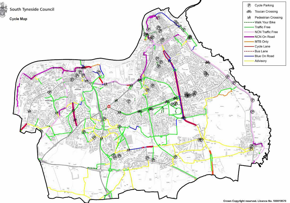
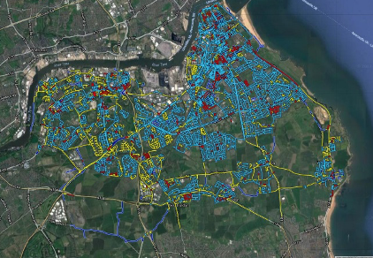
STC has a range of both on road and off-road cycling facilities. These are shown in figure 3. The map indicates that majority of the key cycling routes are either advisory or traffic free with most of the on-road infrastructure concentrated towards the town centre areas of South Shields, Jarrow and Hebburn, along with the connections between villages.
There are opportunities for development of the local network, particularly within the east and west of the South Tyneside where the connections to urban areas are less developed. Trips to North Tyneside across the River Tyne can be accessed via the Tyne Pedestrian Tunnel or the Shields Ferry service.
Walking
South Tyneside has an established network of pedestrian footways and footpaths across the Borough. Particularly within the urban areas and villages in which residents can use to travel both short and long distances.
The process for establishing the defined walking network was based on the following:
- Identifying and mapping walking trip generators;
- Identifying core walking zones and key walking routes;
- Identifying barriers and severance on the local pedestrian networks and;
- Establishing the necessary improvements
Further to this, the walking provision within South Tyneside is complimented by an extensive network of bridleways and public rights of way, with an adopted Public Rights of Way plan for the Tyne and Wear area in place.
- Identifying and clustering trip origin and destination points
- Establishing walking routes and core walking zones
- Auditing the main routes and identifying barriers
Evidence Base
Identifying trip generators
To help develop the LCWIP, work was undertaken to identify major trip origins and destinations and understand their influence on how journeys are made.
These included:
- Major employment sites;
- Sizeable residential areas;
- Hospitals and health centres; and
- Schools and colleges
Cycle volumes/ Automated Traffic Count (ATC) data
STC has a range of Automated Traffic Counters, (ATC’s) located across the Borough. These count vehicle traffic but several also monitor cycling on key routes. These are distributed on important Local and National cycle routes such as the National Cycle Network (NCN). This information is held and publicly accessible using the Tyne and Wear Traffic Accident Data Unit (TADU) which is the primary source of transport and road safety data.
Generally, the number of recorded cycling trips has increased across each of the operational ATC’s. This is in addition to the doubling of recorded cycling trips since 2007. The information from the count data highlights the increasing popularity of travelling to, from and within South Tyneside by bicycle. This needs to be encouraged and where possible increased.
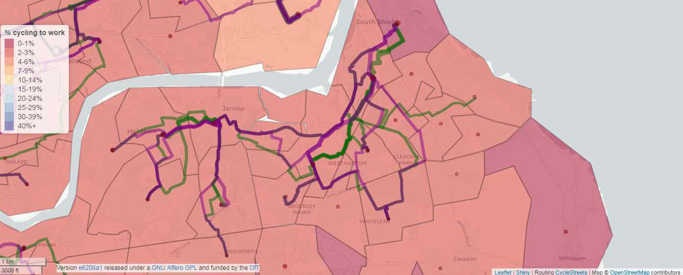
Propensity to Cycle Tool/Spatial mapping
Following a review of the available data to identify which routes are currently most popular, it is important to understand where South Tyneside Council can encourage the highest levels of changing people’s travel behaviours to use sustainable transport - whilst targeting investment to where it will make the greatest difference to residents and visitors.
Using 2011 Census data and background algorithms, the Propensity to Cycle (PTC) Model can be used to identify where cycling levels differ between areas and more importantly where the greatest change can be realised.
The routes that are most likely to affect changing people’s travel behaviours to use sustainable transport within South Tyneside are shown within Figure 5. This model gives some insight into where the greatest levels of cycling can be increased.
Whilst this model is crude, it is both a widely recognised and an adopted tool for the analysis of new active travel routes. Further, using Census data, the model can be independently verified and in several years recalibrated to judge performance.
Health
Improving the health of our residents using active travel through increased cycling and walking is a key objective of this plan. This can also act as a means of tackling obesity and everyday illnesses.
Studies such as the Active Lives Survey by Sport England - summarised in Figure 5, demonstrates that South Tyneside is one of the most inactive Local Authorities in the United Kingdom. Whilst over 70,000 (50%) of adults are classed as physically active and completing over 150 minutes of exercise per week within the Borough this varies by socio economic group and spatially.
Sustainable Transport can be accommodated within everyday life and can replace some general journeys by private car.
It can also be used as an effective means to treat long term health issues including depression, obesity and some muscular skeletal ailments. In short, being more active will help residents lead happier, healthier and most importantly longer lives.
The Council will continue to work with local groups including Local Healthcare Trust, Public Health and Sports Development organisations/groups within South Tyneside Council to help reverse this trend and promote the use of Active Travel Modes.
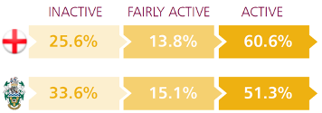
| Location | Inactive | Fairly active | Active |
|---|---|---|---|
| England | 25.6% | 13.8% | 60.6% |
| South Tyneside | 33.6% | 15.1% | 51.3% |
Road safety
Under the 1988 Road Traffic Act, local authorities have a statutory responsibility for road safety.
Therefore, it is important when reviewing and planning new routes that the Council must;
- Undertake a thorough review of collisions along each identified route;
- Identify any underlying conditions or behaviours that may cause;
- Work with local user groups or organisations;
- Deliver improvements;
- Support with promotional materials, and;
- Monitor as necessary.
To increase the levels of sustainable transport modes for everyday journeys, it is imperative that collisions on the highway network are identified and addressed within this plan.
Highway condition data
To assist with the identification of routes which may require repair or enhancement, the Council prioritises infrastructure renewal to areas of greatest need using data sets. To make certain that highway networks - including local cycleways and footways - are of an acceptable standard for use, condition surveys of the infrastructure are undertaken on a regular basis to ensure that the assets are maintained in accordance with local and national strategies.
In addition to ensuring that existing highways assets are improved over time as part of the Highways Maintenance programme, the development and installation of new or improved infrastructure is undertaken. This new infrastructure will be designed in accordance with current best practice (LT1/20 Cycling Infrastructure Design) and to local planning requirements.
Through this process of robust maintenance and inclusive of future planning and designs, it will ensure that businesses and homes continue to be within a short distance of sustainable transport infrastructure - both now and in the future. This makes sure that everyone will have the option to travel using sustainable modes - not just by private car.
Accurate condition data, as shown in Figure 7, ensures that elements in greatest need are enhanced over the course of each Financial Year.
Climate change
South Tyneside Council declared a climate change emergency on 18 July 2019. The Council is committed towards a sustainable future, striving towards carbon neutrality across Council buildings and operations by 2050.
‘Sustainable South Tyneside 2020-2025’ is the Council’s climate change strategy and five-year action plan, which covers key themes to bring about carbon neutrality for the Council. From a Transport Perspective, the Council will continue to drive improvements by:
- Reducing the need to travel
- Promote the use of public transport and active travel
- On-going installation of EV charge points at council sites
- Investigating, implementing and promoting sustainable transport
- Decarbonising fleet vehicles
- Ensuring that businesses that work/contract with the Council have green fleet and carbon neutral ambitions
The opportunities presented by promoting and improving active travel, as identified in this Local Cycling and Walking Infrastructure Plan will support and address the case for carbon neutrality by 2050.
Air Quality
The Council is required to monitor and report on air quality through a statutory requirement determined by the Department for Environment, Food and Rural Affairs (DEFRA), with a status report being submitted annually.
Traditionally, air quality issues were generated by heavy industry and coal heated homes. However, the main cause of air pollution in the Borough is now associated within motorised transport and this is reflected in the extent of air quality monitoring within the Borough.
Congestion and the build-up of exhaust emissions, in particular - Nitrogen Oxide can lead to potentially harmful levels of gas adjacent to the public highway. Significant exposure to this can eventually lead to adverse health effects.
Cycling and walking, particularly for short journeys can reduce the impact of traffic on the local highway network at peak times. This lowers congestion at network pinch points allowing traffic and public transport vehicles to travel more reliably improving network resilience. Vehicles that are continually moving as opposed to stationary or ‘stop / start’ traffic, will ensure that levels of air pollutants created by vehicles will be reduced in certain areas. More importantly fewer vehicles on the network, irrespective of their emissions rating will reduce levels of emissions within the Borough.
As part of this plan, the Council will encourage the use of sustainable transport to reduce the reliance on the private car, thus reducing congestion from vehicle emissions.
Network planning for sustainable growth
Introduction
Following the development of a robust evidence base, the Council can determine where the dominant flows of both pedestrians and cyclists are undertaken throughout the Borough and define how these routes can be improved. However, it is imperative to understand what is important to residents and to adequately cater for their existing and future needs for cycling and walking.
To do this, a series of consultation initiatives was undertaken where the public and key external stakeholders were invited to give their views on cycling and walking in the Borough. These events were supplemented by an online portal called Commonplace where members of the public were invited to submit their comments and suggestions for improvements to the cycling and walking networks.
This was published online for over 20 weeks between 1 November 2019 – 31 March 2020. To further encourage participation, a series of marketing and communication was undertaken, and information displayed within local public buildings to encourage participation. Information was also passed to local key consultees who included;
- Tyne and Wear Joint Local Access Forum
- North East Combined Authority
- North East Local Authorities
- Nexus
- Sport England
- South Tyneside Bus Forum
- Sustrans
- Highways England
- Newcastle Cycle Forum
- Local Disability Groups
- British Horse Society
In total, over 664 separate contributions were received from over 200 separate organisations and the public over the course of the consultation period. A summary of these responses, including demographic data is included in Annex A.
Spaital assessment
Through the consultation process for this document a series of major and minor upgrades were identified. Principally these are classed into two groups;
- Major strategic routes, and;
- Small scale alterations, clustered into minor routes or areas.
From this process, most users were concerned with issues within their local electoral wards and local neighbourhoods; only a minority of responses and typically from community groups were concerned within the delivery of major long-distance routes.
Cycling
There were three main categories of request which were placed across the Borough;
- Permanent opening of parks/spaces for cycling;
- Maintenance requests of existing routes, and;
- Requests for new on/off road connections
Each request has been read and assessed. Many of the suggestions made through the consultation process have been considered nad integrated into future propsals as shown in the next section.
Walking and other non-motorised users
All residential estates within an urban locality should be connected to local shops, services and transport interchanges by a mixture of standard or segregated footways that are suitable and fit for purpose. Many of these respondents were concerned with the ability to get from their place of residence to a destination, often a school, shop or service such as Metro without the fear, perceived or otherwise, interaction with the private car. This group will also include groups that use the footways including the blind/partially sighted and those using mobility vehicles.
Many of the requests received from pedestrians were related to traffic outside of schools, dropped kerb requests and new crossing requests.
Public transport - integration and accessibility
It’s essential that the importance of active and sustainable travel is adopted, particularly when accessing public transport interchanges in the Borough. It is important that residents are connected sustainably to;
- New and existing Park and Ride sites;
- Provision of secure Cycle Parking at Metro and Bus interchange points,
- Access to bus stops and;
- Local residential areas
By considering this and acknowledging that public transport, such as the Metro or bus allow residents of the Borough to access jobs and facilities, it is crucial that there is enough multi modal connectivity to ensure that this happens sustainability.
The importance of the ‘last mile’ travel is a crucial element in terms of Public Transport, as dedicated routes to bus stops, metro stations and interchanges will influence the modal choice for people within the Borough.
Cross boundary schemes
The initial analysis and consultation exercise undertaken has highlighted there are significant opportunities to increase accessibility to neighbouring Authority areas, particularly as the International Advanced Manufacturing Park and Follingsby Park are developed, alongside taking advantage of the opportunities presented by the Tyne Pedestrian and Cycle Tunnel. These sites and connections provide unparalleled access to employment opportunities and should be utilised wherever practicable. Wider connectivity to the city centre areas of Newcastle and Sunderland will also be promoted for commuting purposes.
Evidence from the PTC model indicates that more direct routes are the priority for cross boundary commuting. Routes of this nature will continue to be assessed throughout the Plan period.
The Council will continue to work with neighbouring local and regional authorities to ensure that our plans are clearly communicated to regional stakeholders. This will ensure that our plans are suitably considered and where economies of scale or mutually beneficial construction timescales can be realised, or joint external funding bids are formulated.
Network Plan
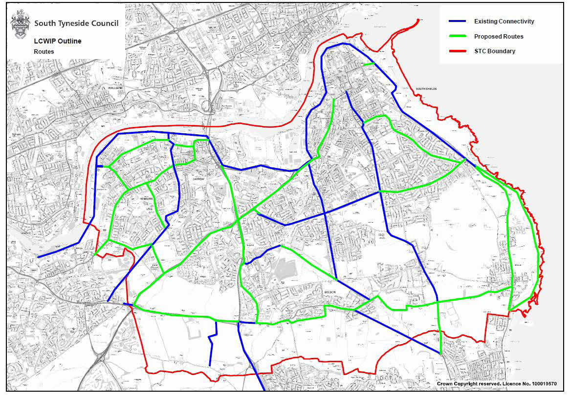
Following the consultation exercise which concluded during Spring 2020, an initial network improvement plan has been identified in figure 8.
In addition to route development, the map includes;
- Strategic cross boundary cycling and walking routes;
- Small scale alterations within an urban setting, such as in townships/vilages;
- Connectivity to local public transport interchanges/local destinations, and;
- Active travel routes that make connections solely within South Tyneside
The Council has developed a scoring framework to score each route or project area in a transparent and accountable manner. This document is being treated as a ‘live’ project. As such, additional cycling and walking routes and suggested improvements can be built into the plan. These will continue to be assessed impartially.
The development of new routes will also be supported by improvements to the local highway network. For example, within housing estates and residential streets through consideration to additional 20mph zones and localised road safety improvements, particularly concentrated around schools. This will ensure large areas are suitable for encouraging active travel modes.
Furthermore, these will be connected via a series of strategic routes allowing safe, accessible travel both on and off road across the Borough.
Prioritising improvements
Whilst it is important to identify new or improved routes, the Council has recognised the importance of leveraging external funding and developing joint bids across the North East region will be important in order to deliver meaningful change within South Tyneside.
This will mean that schemes, when funding is available, will have to be prioritised in accordance with need. South Tyneside Council has developed a scoring methodology which will be used throughout the Plan, this is supported by nationally recognised tools provided by the DfT and others such as the Active Modes Appraisal Toolkit (AMAT) and PTC tool.
All schemes that are suggested for future consideration will be assessed using these tools. For internally funded projects, those that score highly will be progressed in favour of those which score less favourably. However, these scores are once again subject to the amount of funding that is available through grant funding, internal resources or competitive tendering.
Other factors, such as the future development sites identified through the emerging Local Plan process will be considered during the network planning and delivery phase. It is important that infrastructure is also ready for use prior to the completion of new housing developments. This, in addition to supporting Travel Planning activities will ensure that new residents are both aware of their travel options and have the capabilities to use them quickly.
Both the cycling and walking prioritised route improvements, can be found in Figures 8 and 9 within this plan.
| No | Location | Area | Indicative cost (£m) |
|---|---|---|---|
| 1 | A194 cycle route | South Shields to Whitemare Pool | 2m |
| 2 | A185 cycle route | South Shields to Gateshead via Jarrow and Hebburn | 3m |
| 3 | A184 cycle route | From Testo's to Whitemare Pool, HE land | 1.5m |
| 4 | NCN14 improvements | NCN14 near between A19 Lindisfarne and South Shields | 1m |
| 5 | NCN 1 improvements and accessibility | Full route improvements | 1m |
| 6 | Lukes Lane | Central Hebburn | 0.5m |
| 7 | River Don route improvements | South Tyneside - Cross authority route | 1.5m |
| 8 | Village enhancements - Whitburn to Boldon | Various | 2m |
| 9 | Harton Mineral Line Access | South Tyneside - cross authority route | 0.5m |
| 10 | Follingsby Lane | Boldon to Gateshead | 0.5m |
| 11 | Erskine Road/A194 Barrier Removal | South Shields | 0.25m |
| 12 | Ocean Road | South Shields | 0.75m |
| 13 | Church Way/Keppel Street | South Shields | 0.5m |
| 14 | Boldon Lane | South Shields | 1.5m |
| 15 | Cleadon Village - Nevinson Avenue | Various | 1m |
| 16 | Mill Lane/Monkton Lane roundabout | Hebburn | 1.5m |
| 17 | Stanley Street - Tyne Dock route reopening | Tyne Dock | 0.25m |
| 18 | Nevinson Avenue/Glasworthy Road | South Shields | 0.5m |
| 19 | Benton Road | South Shields | 0.5m |
| 20 | River Drive/Wapping Street widening | South Shields | 0.25m |
| 21 | Sea Road | South Shields | 0.5m |
| 22 | St Aloysious View | Hebburn | 0.5m |
| 23 | B1297 Waggonway Road | Jarrow - Hebburn | 2m |
| 24 | Temple Park - Coast | South Shields | 2m |
| 25 | Highfield Road | South Shields | 1m |
| 26 | Tyne Dock Missing Link | South Shields | 0.5m |
| 27 | Access improvements to Town Centres | Various | 2.5m |
| 28 | Links to Tyne pedestrian / cycle tunnel | Jarrow | 1m |
| 29 | Last Mile Travel | Various | 0.5m |
| No | Location (Street) | Area / Vicinity | Estimated cost (£m) |
|---|---|---|---|
| 1 | Luke's Lane to Mill Lane | Hebburn | 0.25m |
| 2 | Argyle Street | Hebburn | 0.2m |
| 3 | Beach Road to Garden Lane | South Shields | 1m |
| 4 | Chichester Metro and surrounding area | South Shields | 0.5m |
| 5 | Mowbray Road, Sea Road | South Shields | 0.2m |
| 6 | Wheathall Drive to Lizard Lane | Marsden | 0.3m |
| 7 | County Park to Marsden Grotto | Marsden | 0.25m |
| 8 | Tyne Dock to Throckley Way | South Shields | 0.2m |
| 9 | Hedworth Lane Bridge | Hedworth near Fellgate Metro Station | 0.3m |
| 10 | Edinburgh Road | Simonside Estate | 0.25m |
| 11 | East Boldon Metro footway extension | East Boldon | 0.25m |
| 12 | Melbourne Gardens access path widening | Simonside Estate | 0.2m |
| 13 | Cleadon Village improvements | Cleadon | 1m |
| 14 | Field Terrace / Jarrow School footway widening | Jarrow | 0.5m |
| 15 | Closure of Monksway for traffic | Bede industrial estate | 0.25m |
| 16 | Links to Metro stations | Various | 3m |
| 17 | Town centre improvements | Various | 5m |
| 18 | Village improvements | Various | 3m |
| 19 | Last Mile Travel to public transport | Various | 1m |
Designing for the future
When considering the need to design for the future, it is important that consideration is given to Local Transport Note 1/20 ‘Cycling Infrastructure Design’ guidance. This Local Transport Note provides guidance and good practice for the design of cycle infrastructure, in support of the Cycling and Walking Infrastructure Strategy.
It is expected that third party development will design their active travel infrastructure in accordance with this guidance. In addition to this, a series of design recommendations for developers to adopt for Cycle Parking have been referenced in Annex A.
Development Management
Introduction
In order to make South Tyneside “an outstanding place to live, invest and bring up families”, the impact of development will need to be considered by all. This is an important factor as part of the Council’s emerging Local Plan – a statutory document that outlines the Borough’s growth and development aspirations over the plan period. Active Transport is an important consideration that is addressed within the evidence base and when identifying the required development quantum within the Borough.
Every significantly sized housing and employment site as outlined within the Council’s emerging Local Plan will be subject to a series of transport and sustainability policies and appraisals. These vary by site and location and require developers to bolster connectivity by sustainable modes from the existing network to their sites. This will also be reinforced by sustainable transport promotions and marketing as advocated within our Development Control guidance.
Developments including the strategically important International Advanced Manufacturing Park (IAMP), the Port of Tyne and future Holborn development will have active travel incorporating into their masterplans through travel planning and the promotion of active travel modes and designated routes.
Infrastructure Development
It is important that infrastructure proposed for development is designed in accordance with recognised design standards (LT1/20 Cycling Infrastructure Design). This ensures that the infrastructure is built to the right standard for use by the relevant sustainable groups. Further to this, the Council has cycle parking standards that apply to all developments which can be found in Annex B of the report.
Travel Planning
Travel Planning and influencing how people may travel to potential developments is important in reducing the reliance on the private car. Any new developments should ensure that sustainable modes are preferred wherever practicable for short journeys around South Tyneside.
Travel Planning, along with the softer elements of sustainable transport promotion will also be undertaken principally by the Council through its Road Safety Education Team, and through the promotion of the Go Smarter brand and various local sub brands to reflect activities within schools. These will be delivered as part of a wider package of measures within schools as part of area wide capital initiatives, or as part of new development, linking in with other departments such as Climate Change, Public Health and Education.
Promoting sustainable transport
To ensure that the necessary targets are achieved in terms of people using sustainable transport modes, it is vitally important to ensure that when infrastructure is created that it is promoted in the right manner; generally through standard local and regional communications plan but also through the development planning process and travel plan monitoring.
When considering the need to design for the future, it is important that consideration is given to Local Transport Note 1/20 ‘Cycling Infrastructure Design’ guidance. This Local Transport Note provides guidance and good practice for the design of cycle infrastructure, in support of the Cycling and Walking Infrastructure Strategy.
The Council through its Road Safety Education Team is responsible for delivering several sustainable transport initiatives that provide school children with the access / confidence / training to use sustainable transport modes on journeys to school.
Road safety education
Bikeability
Bikeability is a Government led cycle training programme which provides practical skills and understanding how to cycle on today’s roads. South Tyneside Council operates Bikeability within our educational facilities in which our school children are trained in groups during school time.
The Council receives funding via the Department for Transport to deliver Bikeability training, with the Council employing professional, qualified cycling instructors to provide the training.
The Council currently offers the following training:
- Bikeability Level 1 aims to develop cycle handling in an off-road environment and prepare riders for cycling on the road (Years 3).
- Bikeability Level 2 will develop riders’ skills and confidence for cycling on quieter roads (Years 5 & 6).
The training offered as part of Bikeability provides school children with the confidence to travel using active travel modes in their later lives.
Independent choices
The independent choices programme involves preparing Year 6 pupils for the transition to secondary school and offers an insight into the travel options available when making the journey to school.
The movement from primary school to secondary school can often involve longer distances, so children receive training and information on the travel options including cycling and walking along with public transport options.
This training promotes the use of sustainable transport, rather than the school children travelling to school by private vehicle.
Child pedestrian training
Child pedestrian training is aimed at Year 3 and Year 4 pupils in Primary School and is delivered through the Go Smarter to Schools project. Children are encouraged to develop strategies for crossing the road safely and supervised by qualified road safety trainers.
This training allows the children to get proficient at:
- Choose safer places to cross the road
- Crossing safely near parked cars
- Crossing safely at junctions
Go Smarter Programs within South Tyneside
In order to encourage and further promote sustainable and active transportation within schools, transport initiatives have several complementary themes and delivery partners.
Go Smarter is standard the sustainable transport brand Tyne and Wear, Durham and Northumberland.
Regional resources currently include:
- Online journey planners;
- Walking Zone analysis tools;
- Teaching reosurces, and;
- Cycle maps for South Tyneside - hard copy or digital.
Many of these will be refrehed to give clear indication of South Tyneside's vision.

Healthy Schools
Work will be undertaken with Public Health and the Healthy Schools programme within South Tyneside and adopt a ‘bottom up’ approach to delivery to ensure ongoing sustainability. There are clear links between health and transport, because of this additional emphasis will be placed on cycling and walking within the existing Healthy Schools Programme and accreditation process.
School Streets Initiative
The School Street Initiative offers a proactive solution for school communities to tackle air pollution, poor health and road danger reduction. A School Street scheme will encourage a healthier lifestyle and active travel to school for families and lead to a better environment for everyone.
A School Street is a road outside a school with a temporary restriction on motorised traffic at school drop-off and pick-up times. The restriction applies to school traffic and through traffic. The result is a safer, healthier and pleasant environment for everyone.
South Tyneside Council intends to develop and adopt school streets initiatives across the Borough (subject to the appropriate consultation) and will work with local community groups to promote active travel. This will include a requirement for schools to complete an annual Hands Up survey and an aspiration to undertake a Modeshift STARS accredited Transport Plan. The Council will support schools in this process and delivering relevant and engaging activities that further this process.
Application
Securing funding to deliver improvements
South Tyneside Council has attained a strong relationship with external funding providers which has resulted in the successful funding bids to enhance or promote sustainable travel infrastructure across the Borough. In addition to local transport plan funding from Central Government, there are several external funding opportunities to improve active travel routes which will then benefit the residents of South Tyneside and school children. Several of these potential funding sources will be outlined below;
External grant funding
South Tyneside Council has a proven and successful track record of identifying external funding in order to promote and develop sustainable travel across the Authority. Key organisations include Central Government Departments such as the Department for Transport (DfT) and Department for Housing, Local Communities and Local Government and Energy Savings Trust. Typical examples of this funding can be found below:
- Active Travel Funding
- Funding to enable road space reallocation exercises for active travel priority
- Active Travel Capability Funding
- Revenue based funding to support Active Travel Modes
- Transforming Cities Funding
- Funding to transform access into major urban areas
- Local Growth Funding
- Funding to support sustainable travek linked to economic growth
Further external funding sources will be explored throughout the life of the Plan, in addition to other types of grant funding from non-governmental organisations including the Heritage Lottery Fund.
Internal funding
The principal source of funding for Local Authority highway led schemes is through the annual Capital Programme of Works (CPW). This is an annual allocation of Local Transport Plan Funding (LTF) from Central Government which South Tyneside Council uses to develop many of its Road Safety, Sustainable Transport and Highways schemes.
Community Infrastructure Levy
Community Infrastructure Levy (CIL) is a charge against developments that may be raised against a Landowner or the relevant appointed body. Once received, authorities must spend this levy on health, transport and education infrastructure that is needed in the area surrounding the development. Crucially, this can be used either to create new infrastructure or enhance the existing facilities, such as pedestrian crossings and footways that are subject to impacts as a direct result of development, as well as wider cycling and footpath improvements.
Planning obligations
These legal agreements in which a developer is committed to contributing financially or in kind works in order to mitigate the impact of development within a specified area. Typically, these works fall under an agreement known either as a Section 106 (S.106) or Section 278 (S.278) and will extend to include improvements to cycling and walking routes.
Eventually these will be converted to CIL as the Local Plan is developed in the coming years. This is a more flexible arrangement that can be used in local areas on projects.
Monitoring of the LCWIP
The importance of this plan is that South Tyneside Council is monitoring performance against several performance indicators. The Council and Regional Transport partners has access to a number of datasets that can be monitored throughout the year to provide both a baseline and as a long term measure of success.
Please see Figure 11 below for further information:
| Category | Responsible body | Frequency of survey | Target | Review |
|---|---|---|---|---|
| Collision data | Local Highways Authority | Ongoing | Reduce the number of collisions on the network | Quarterly |
| Census data | Central Government | Every ten years | N/A | Ad hoc |
| Highway condition data | Local Highways Authority | Ongoing | Continue to improve the condition of highway assets | Annually |
| Automated Traffic Counters - Bicycle and vehicles | Local Highways Authority | Ongoing | N/A | Quarterly |
| Travel Plans surveys | Local schools/Businesses Road Safety Department | Annually | Increase the number of Travel Plans and frequency of monitoring at destinations | Annually |
| Hands Up surveys | School Travel Plan officers | Annually as part of the Travel Plan refresh | Increase the number of Hands Up surveys within schools | Annually |
| NCN reviews | Sustrans | Ongoing | Monitor and where applicable improve the local National Cycle Network | Ad hoc |
| Cycle route inspections | Local Highways Authority | Annually | An annual review of the main cycle routes to ensure safe use | Annually |
| School Streets Delivered | Local Highways Authority | Annually | Initial successful engagement, full adoption of school streets approach by end of Plan | Annually |
It is expected that the collection of these datasets will continue throughout the life of the plan and as part of the general duties of South Tyneside Council and its local delivery partners. As a result, there is minimal risk of loss, or discontinuation of these datasets. This ensures that robust monitoring can occur over the longer term with minimal interruption.
Each potential scheme that is delivered by the Local Authority will have an appropriate level of pre and post scheme assessment to ensure that the funding committed to a scheme is both appropriate and suitable for the schemes. As a minimum this will include a review of:
- Local collision data (STATS19), and;
- Traffic and pedestrian data
Schemes will also be subject to a standard consultation process with local elected ward members, their opinions both before and after will be gauged as a means of public acceptability. This process is also extended to appropriate Community Action Forum (CAF) meetings, where required.
Internal/external reporting
Democratic and Professional accountability are also vitally important in the development of the LCWIP. However, it’s also important to ensure that the level of reporting is both appropriate and suitable for the level of activity that is proposed. To that end a series of internal and external reporting mechanisms are proposed.
Internal reporting
To ensure that this occurs, the development of the LCWIP will become a standard update item at regular internal highways and council group meetings.
External reporting
It is important that external bodies and more importantly the residents of South Tyneside can understand the deliverables from this programme.
Major active travel schemes will be consulted upon with residents and the successful implementation of schemes shall be publicised as required.
Integration with current policies and strategies
Promoting sustainable transport is a statutory duty from all levels of Government and several public bodies. This is due to the well-recognised view that cycling, walking and using alternative modes of transport can have a positive impact on a person’s health and wellbeing but it can also reduce congestion, particularly during peak periods when traffic volumes are highest.
How this LCWIP aligns to existing strategies can be found in Figure 12 below.
| Existing strategy | LCWIP strategies | |
|---|---|---|
| National Policy | Cycling and Walking Infrastructure Strategy | |
| Sub Regional Policy Framework | Strategic Economic Plan | |
| Sub Regional Transport Policy/Evidence Base | North East Transport Plan (Draft) | |
| Local Policies | Local Cycling and Walking Infrastructure Plan | South Tyneside Physical Activity Strategy |
| Climate Change Strategy | Highways and Transport Infrastructure Plan | |
| South Tyneside Local Plan (Draft) | South Tyneside Strategy | |
Summary
This document outlines South Tyneside Councils aims for active travel, specifically cycling and walking within the Borough.
Within this document, a range of active travel user groups have been identified and their needs have been reviewed. This process identified which improvements users expect to see on the network and what is being progressed to meet their needs in the short-medium term and includes a range or promotional and infrastructure projects. Broadly, this process includes:
- Working to develop new and a connected network of active travel rotues / corridors both within and across the boundaries of South Tyneside;
- Developing an established culture of sustainable transport as a viable transport mode for everyday journeys;
- Applying best practice to asset management to ensure infrastructure can be used safely and sustainably;
- Delivering new infrastructure solutions, appropriate to new and future residents and;
- Promoting sustainable travel with Public Health and associated partners under local well recognised brands
In addition, there is a clear focus within the document for developing the sustainable transport infrastructure for the benefit of residents, commuters and visitors to the area without compromising existing levels of service.
These will be the guiding principles behind future programmes of work that seek to develop a series of enhanced routes throughout the life of this and associated Policy and Strategy documents. With the assistance of partners to develop new routes, these positive actions will be followed by increased promotion of activities and facilities under the “Go Smarter” brand.
It is anticipated that plan will have a visible impact on the active travel network and in accordance with local transportation and planning policies assist in creating a greener, healthier and more importantly accessible South Tyneside.
Consultation Survey Responses
The first analysis identifies the sentiment of the responses received from the Common Place survey exercise undertaken.
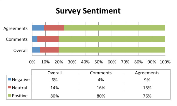
| Overall | Comments | Agreements | |
|---|---|---|---|
| Negative | 6% | 4% | 9% |
| Neutral | 14% | 16% | 15% |
| Positive | 80% | 80% | 76% |
This high-level graph recorded the nature of each comment that was raised. It demonstrated that most respondents to this survey were very positive and contributed appropriately. Where this was not the case in less than 10% of responses with most respondents typically dissatisfied with the level of maintenance on the walking and cycle networks.
Typically, most respondents to this consultation were male with only 40 identifying as female.
Given the electronic nature of this consultation we have received the highest percentage (30%) of respondents from the 45-54 age category. Over 30% of our respondents identify as under 44, this demonstrates a significant rise in younger levels of respondents relative to previous consultations and justifies the use of a consultation as our primary method of public engagement.
In whilst it was positive to see that many people who responded to the surveys both walk or cycle, it is clear that many people still are single drivers to their places of work or leisure.
This question allowed people to choose multiple options and as a result the percentages do not add up to 100%. Whilst that is the case it demonstrates that most respondents to this survey are local residents with smaller numbers of commuters from outside of the Borough.
| Category | Number |
|---|---|
| Very confident | 68 |
| Somewhat confident | 106 |
| Not comfortable | 0 |
| Not very confident | 7 |
| Not at all confident | 10 |
| N/A | 25 |
| Total | 216 |
| Category | Number |
|---|---|
| Very comfortable | 47 |
| Somewhat comfortable | 83 |
| Not comfortable | 64 |
| Not very comfortable | 0 |
| Not at all comfortable | 0 |
| N/A | 22 |
| Total | 216 |
These two questions are subjective in nature and associated with the general perception of active travel in South Tyneside. For both questions is it positive to see that most individuals are both positive and comfortable with the present level and quality of transport infrastructure in the Borough.
Appendix B - Cycle Parking Standards
The following table projects the expected cycling parking amounts in respect of the category of planning application:
| Category | Description | Quantity |
|---|---|---|
| A1 Shops | Small shops (less than 500sqm) | 2 spaces per 100m2 |
| Supermarkets (500 - 2500sqm) | 2 spaces per 500m2 | |
| Superstores (more than 2500sqm) Hypermarket, DIY centre, Garden Centre, Builders Merchants | 2 spaces per 500m2 | |
| Retail Warehouses 2 spaces per 750sqm for staff and visitors | 2 spaces per 500m2 | |
| A2 Financial and Professional Services | Financial and professional services | 2 spaces per 200m2 |
| A3 Restaurants and Cafes | Restaurants, snack bars and cafes | 2 spaces per 50sqm for staff and visitors |
| Drive Through Restaurants | 2 spaces per 50sqm for staff and visitors | |
| A4 Drinking Establishments | 2 spaces per 50sqm for staff and visitors | |
| A5 Hot Food Takeaways | Hot Food Takeaways | 2 spaces per 50m2 |
| B1 Business | Offices, research and development, light industry | 2 spaces per 50m2 |
| B2 Industrial | General industrial use | 2 spaces per 50m2 |
| Vehicle Repair Garage | 1 space per 2 staff | |
| B8 Storage and Distribution | 1 space per 500m2 | |
| C1 Hotels | Hotels, boarding houses and guest houses | 1 space per 10 bedrooms, plus 1 per 50m2 GFA conference rooms |
| C2 Residential institutions | Residential schools and colleges | 1 cycle space per 5 staff plus parking for occupants |
| Convalescent/ Nursing homes | 1 space per 5 staff | |
| Hospitals/ Inpatient clinics | 1 per 2 staff. 1 per 20 beds | |
| C2A Secure Residential Institutions | 1 space per 5 staff | |
| C3 Dwelling houses | Houses | 1 space per dwelling |
| Flat | 1 space per dwelling | |
| Purpose built student accommodation | 1 space per 10 residents | |
| Old people housing (Individual dwellings) | Between 0-1 space per dwelling | |
| Sheltered accommodation for elderly etc. | 1 space per staff | |
| C4 Houses of multiple occupation | Small shared houses occupied by between three and six unrelated individuals | 1 space per unit, plus 1 space per 5 units for visitors |
| D1 Non residential institution | Day nursery and Crèches | 1 space per 5 staff |
| Doctors, dentists and veterinary practices | 1 space per 5 staff | |
| Primary schools | 1 per 5 staff, 1 per 10 pupils | |
| Secondary schools | 1 per 5 staff, 1 per 10 pupils | |
| Sixth form colleges - Higher education establishments | 1 per 5 staff, 1 per 10 pupils | |
| Art galleries, museums, public halls, exhibition halls | 2 per 200m GFA | |
| Libraries | 2 per 200m GFA | |
| Places of Worship or Religious Instruction | 2 per 200m GFA | |
| D2 Assembly and Leisure | Ciemas, concert halls, bingo halls, casinos | 2 per 200m GFA, 1 in 10 staff |
| Dance halls, discotheques, nightclubs | 2 per 200m GFA, 1/5 staff, plus A3 and A4 considerations | |
| Sports clubs and centres, sports grounds, swimming pools, skating rinks etc. | 2 per 100m GFA, 1/5 staff plus A3 and A4 considerations | |
| Sui Generis | Theatres | 2 per 200m GFA, 1/10 staff |
| Amusement arcades/funfairs | 1 per 10 staff | |
| Laundrettes, petrol filling Stations, Car showrooms | 2 per 200m2 GFA | |
| Hostels | N/A | |
| Sales rooms | 1 per 5 staff | |
| Social clubs | N/A | |
| Metro/rail stations | N/A | |
| Bus interchanges | N/A | |
| Park and Ride facilties | N/A | |
| Petrol stations | 1 per 3 staff | |
| Taxi rank | 1 per 5 staff | |
| Caravan site | 2 per pitch, 1 per 3 staff | |
| Golf courses | 1 per 10 staff + A3 and A4 considerations |